
Bethuadahari Wildlife Sanctuary
| Bethuadahari Wildlife Sanctuary | |
|---|---|
Bethuadahari | |
| Coordinates | 23°35′51″N 88°23′31″E / 23.5975516°N 88.3920227°E |
| Area | 67 hectares (170 acres) |
Bethuadahari Wildlife Sanctuary is situated in the
Geography

5miles
Wildlife Sanctuary
check point
Dewanganj
M: municipal town/ city, CT: census town, R: rural/ urban centre, H: place of historical/ religious interest, T: place of tourist interest.
Owing to space constraints in the small map, the actual locations in a larger map may vary slightly
Location
Bethuadahari Wildlife Sanctuary is located at 23°35′51″N 88°23′31″E / 23.5975516°N 88.3920227°E.
Note: The map alongside presents some of the notable locations in the subdivision. All places marked in the map are linked in the larger full screen map. All the four subdivisions are presented with maps on the same scale – the size of the maps vary as per the area of the subdivision.
Fauna and flora
The sanctuary has a large population of
As of the 1995 census, it had 297 chital deer.[1]
Among the trees found within the sanctuary are shal, teak, arjun, Indian rosewood, and bamboo.[3]
Bethuadahari picture gallery
-
 NH 12 at Bethuadahari
 -
 Bethuadahari Wildlife Sanctuary entrance
 -
 Jatri Niwas
 -
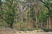 The forest


References
- ^ a b "Nadia District, West Bengal". Pilgrimage and tourist sites. District administration, Government of West Bengal. Retrieved 14 February 2009.
- ^ a b c "West Bengal Wildlife Sanctuaries: Bethuadahari Wild Life Sanctuary". Directorate of Forests, Government of West Bengal. Archived from the original on 10 October 2010. Retrieved 2 January 2013.
- ^ a b "Bethuadahari Wildlife Sanctuary". West Bengal Tourism, Official Website, Department of Tourism, Government of West Bengal. Archived from the original on 2 January 2013. Retrieved 2 January 2013.
External links
 Bethuadahari travel guide from Wikivoyage
 Media related to Bethuadahari Wildlife Sanctuary at Wikimedia Commons
This article about a location in the Nadia district of West Bengal is a stub. You can help Wikipedia by expanding it. |
This article about protected areas of India is a stub. You can help Wikipedia by expanding it. |