
Ein Samiya
Ein Samiya | |
|---|---|
| Arabic transcription(s) | |
| • Governorate | Ramallah and al-Bireh |
| Elevation | 430 m (1,410 ft) |
| Population | |
| • Total | 0−300 |
| Name meaning | "the lofty spring[2] |
.jpg)
Ein Samiya, also known as Ain Samia (
Due to its large water spring, considered to be the strongest and purest in the region, the Ein Samiya valley is an important archaeological area containing the remains of settlements dating back to the ancient Bronze Age/Canaanite era, as well as Roman and Islamic periods. In modern times, Ein Samiya's spring water is the main local ingredient of Taybeh beer, Palestine's first local beer.[4][5]

In May 2023, the village was forcibly evacuated, having been home to 178 people.[6] Acting Humanitarian Coordinator for the Occupied Palestinian Territory, Yvonne Helle, noted that: "These families are not leaving by choice; the Israeli authorities have repeatedly demolished homes and other structures they own and have threatened to destroy their only school. At the same time, land available for the grazing of livestock has decreased due to settlement expansion and both children and adults have been subjected to settler violence... We are witnessing the tragic consequences of longstanding Israeli practices and settler violence."[7][6]
The persistent harassment of the Palestinian villagers, leading to their evacuation in 2023, is considered to be part of the Israeli expropriation of Palestinian springs in the West Bank.[6]
Location

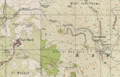
The town is located on the eastern slopes of the Ramallah mountains, and the town's territory reaches Al-Auja in the Jordan Valley in the east of the West Bank.[8]
Economy
Ein Samiya is a large water spring, considered to be the strongest and purest in the region, as it supplies water to the city of Ramallah and Al-Bireh. Historically, large networks of water channels were built. The village serves as the food basket of the town of Kafr Malik, where grains, thyme, citrus fruits, and vegetables are grown.[3]
Population
Most of the population is from the Bedouin Ka'abneh (
History and archaeology
Dating back more than 7,000 years, Ein Samiya contains what is considered one of the oldest historical ruins in the world. It also includes more than 150 rock-carved Roman tombs and related tunnels. Numerous archaeological expeditions took place in 1941-42 and in 1963.[13][14]
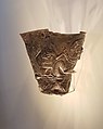
The area includes many historical symbols that indicate the cultural diversity in the place, and the site of "Tel Al-Marzbanah" north of Ein Samia is one of the most prominent archaeological sites in it, and it is a small high site that extends from north to south. The origin of the name goes back to the Persian language, as Marzipan means minister. The 'Ain Samiya goblet was found here.[13][14]
Ottoman era
The village is not mentioned in the first
In 1838, es-Samieh was noted as a Muslim village in the District of Beni Salim; located east of Jerusalem.[22]
In 1870,
In 1882, the
Gallery
-
 Middle Bronze AgeI (2300-2000 BC)
 -
 A flat rendering of the scenes depicted on the Ain Samiya Goblet
 -
 Kafr Malik and Ein Samiya in the 1880s
 -
 Kafr Malik and Ein Samiya in the 1940s
 -
 Oasis of Ein Samia - panoramio, 2010
 -
 Cultivated fields at Ein Samiya, 2010
 -
 Oasis of Ein Samiya, 2010
 -
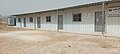 School in Ein Samiya, 2 May, 2023
 -
 Evacuation of Ein Samiya, 25 May, 2023
 -
 Ein Samiya after evacuation, 25 May, 2023


.jpg)
.jpg)


References
- ^ a b c d e Finkelstein et al., 1997, p. 734
- ^ a b Palmer, 1881, p. 251
- ^ a b ""عين سامية".. مياه وتاريخ في مواجهة الاستيطان". Anadolu Ajansı (in Arabic). 2019-10-04. Retrieved 2023-05-26.
- ^ "Palestinian beer: Taybeh on tap". The Jerusalem Post. 2012-10-18. Retrieved 2023-05-29.
- JSTOR 10.1525/gfc.2014.14.4.69.
- ^ a b c "Palestinian community forced to evacuate Ein Samia - UNOCHA". The Jerusalem Post. 2023-05-26. Retrieved 2023-05-26.
- ^ "Occupied Palestinian territory - Palestinian community compelled to relocate amid Israeli settlement practices" (Press release). United Nations Office for the Coordination of Humanitarian Affairs. 2023-05-25. Retrieved 2023-05-26.
- ^ ""عين سامية".. مياه وتاريخ في مواجهة الاستيطان". Anadolu Ajansı (in Arabic). 2019-10-04. Retrieved 2023-05-31.
- ^ Hass, Amira (2022-07-12). "How to Chase Palestinians Off Their Land - Israel News". Haaretz.com. Retrieved 2023-05-31.
- ^ Wattan News. "بسبب اعتداءات المستوطنين.. أهالي "عين سامية" يهجرون المكان تباعاً". وكالة وطن للأنباء (in Arabic). Retrieved 2023-05-31.
- ^ "بلدة "عين سامية".. حلقة جديدة في مسلسل تهجير الفلسطينين". Asharq (in Arabic). 2023-05-29. Retrieved 2023-05-31.
- ^ موسى, خليل (2023-05-27). ""عين سامية" الفلسطينية ذات الينابيع باتت جحيما". اندبندنت عربية (in Arabic). Retrieved 2023-05-31.
- ^ JSTOR 27925264. Retrieved 2023-05-29.
- ^ JSTOR 27925265. Retrieved 2023-05-29.
- ^ Dauphin, 1998, p. 852
- ^ Macalister, 1907, p. 236
- ^ Abel, 1907, pp. 275-276
- ^ Tsafrir et al, 1994, p. 221
- ^ Pringle, 1997, p. 112
- ^ Toledano, 1984, p. 298 has Samiya at location 31°59′35″N 35°19′10″E.
- ^ Hütteroth and Abdulfattah, 1977, p. 113
- ^ Robinson and Smith, 1841, vol 3, Appendix 2, p. 125
- ^ Guérin, 1874, p. 211, as translated in Conder and Kitchener, 1882, SWP II, p. 394
- ^ Guérin, 1874, pages 211-212.
- ^ Conder and Kitchener, 1882, SWP II, p. 394
Bibliography
- Abel, F.-M. (1907). "Document ephigraphique sur le patriarche Eustochios". Revue Biblique. 16: 275-276.
- Conder, C.R.; Kitchener, H.H. (1882). The Survey of Western Palestine: Memoirs of the Topography, Orography, Hydrography, and Archaeology. Vol. 2. London: Committee of the Palestine Exploration Fund.
- ISBN 0-860549-05-4.
- ISBN 965-440-007-3.
- Guérin, V. (1874). Description Géographique Historique et Archéologique de la Palestine (in French). Vol. 2: Samarie, pt. 1. Paris: L'Imprimerie Nationale.
- Hütteroth, Wolf-Dieter; Abdulfattah, Kamal (1977). Historical Geography of Palestine, Transjordan and Southern Syria in the Late 16th Century. Erlanger Geographische Arbeiten, Sonderband 5. Erlangen, Germany: Vorstand der Fränkischen Geographischen Gesellschaft. ISBN 3-920405-41-2.
- .
- Palmer, E.H. (1881). The Survey of Western Palestine: Arabic and English Name Lists Collected During the Survey by Lieutenants Conder and Kitchener, R. E. Transliterated and Explained by E.H. Palmer. Committee of the Palestine Exploration Fund.
- ISBN 0521-46010-7.
- Robinson, E.; Smith, E. (1841). Biblical Researches in Palestine, Mount Sinai and Arabia Petraea: A Journal of Travels in the year 1838. Vol. 3. Boston: Crocker & Brewster.
- Toledano, E. (1984). "The Sanjaq of Jerusalem in the Sixteenth Century: Aspects of Topography and Population". Archivum Ottomanicum. 9: 279–319.
- ISBN 965-208-107-8.
External links
- Survey of Western Palestine, Map 15: IAA, Wikimedia commons
 | ||||
| Municipalities |
| |||
Village councils |
| |||
Refugee camps |
| |||