Fort Funston
| Fort Funston | |
|---|---|
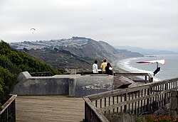
 A hang glider launches from Fort Funston Overlook, San Francisco. The launch platform is modified from a former fire control bunker. | |
| Location | San Francisco, California, United States |
| Coordinates | 37°42′54″N 122°30′07″W / 37.714958°N 122.501915°W |
| Operated by | Golden Gate National Parks Conservancy |
| Website | Official website |
| Fort Funston | |
Lake Merced Military Reservation | |
| Near San Francisco, California in United States | |
| Type | Harbor defense installation |
| Site information | |
| Owner | United States Army |
| Controlled by | United States Army Coast Artillery Corps |
| Site history | |
| Built | 1900 |
| Fate | Decommission 1963 |


Fort Funston is a former
The fort was constructed upon windswept headlands along the
History
The land was acquired by the federal government in 1900 as the
Following World War I, the
In 1940 Battery Davis was joined by Battery Townsley at
From December 1941 through April 1944 Fort Funston's garrison included elements of the 18th Coast Artillery Regiment.[8]
The gun batteries were declared obsolete shortly after
Features
The area is covered with a network of trails suitable for hiking or horseback riding. There are two Dutch sand ladders that extend down the dunes to the beach. The beach is known for its magnetic sand[9] and strong currents, discouraging swimming.[10] Fort Funston is a popular dog park and the only park in the GGNRA that allows off-leash dogs.
The strong, steady winds make the cliffs overlooking the beach a popular site for hang gliding. The gliding is rated intermediate difficulty (Level III).[11] When the NPS first took over administration of the area in the early 1970s, rangers asked hang gliders what they needed. A few months later NPS opened up a gate so fliers could drive up to the old Nike site to park rather than hike in from the road, and they provided a port-a-potty.
Additionally, the world record for the farthest thrown object was set here in 2003 by Erin Hemmings, who threw an Aerobie flying ring 1,333 feet.[12][13]
Wildlife
- Bank swallow(Riparia riparia)
See also
References
- ^ The Coastal Trail is temporarily closed due to erosion.
- ^ a b Fort Funston at FortWiki.com
- ^ a b c d Berhow, p. 217
- ^ a b c d Fort Funston at American Forts Network
- ^ Wurm, Ted (1979). "S.P. Ocean View Line". The Western Railroader. 42 (468). Francis A. Guido: 6&7.
- ^ Berhow, p. 227
- ^ Richmond P. Davis biography at NCpedia.org
- ^ Gaines, William C., Coast Artillery Organizational History, 1917-1950, Coast Defense Journal, vol. 23, issue 2, pp. 12–13
- ^ "Information on black sand at USGS.gov". Archived from the original on 2017-01-18. Retrieved 2012-12-03.
{{cite web}}: CS1 maint: unfit URL (link) - ^ Riggins, Alex; Warth, Gary; Grad, Shelby (August 3, 2019). "Encinitas beach cliff collapse that killed 3 women part of larger California coast crisis". Los Angeles Times. Archived from the original on August 4, 2019. Retrieved July 21, 2020.
{{cite news}}: CS1 maint: unfit URL (link) - ^ "Fort Funston (Tips and Highlights)". Golden Gate National Parks Conservancy. 2 August 2017. Retrieved August 14, 2021.
- ^ "First Quarter Mile Throw in History at Fort Funston". Business Wire. July 16, 2003. Archived from the original on 2013-01-18. Retrieved August 14, 2021.
- ^ "World record toss". Fort Bragg Advocate-News. August 7, 2003.
Erin Hemmings of Mendocino, threw his Aerobie an incredible 1,333 feet.
- Berhow, Mark A., ed. (2015). American Seacoast Defenses, A Reference Guide (Third ed.). CDSG Press. ISBN 978-0-9748167-3-9.
Further reading
- Daerr, Elizabeth G. "Golden Gate NRA Officials Caught In a Dog Fight". National Parks 74 (7-8): 14–15.
- Kent, Matthew W. "4. Fort Funston". Harbor Defenses of San Francisco: A Field Guide 1890 to 1950. 2009. Self-published. ISBN 978-1-61584-163-9.
- Konigsmark, Ted. "Trip 5. Fort Funston". Geologic Trips: San Francisco and the Bay Area. 3rd ed. GeoPress, 2006 [1998]. ISBN 0-9661316-4-9. pp. 98–111.
- Lewis, Emanuel Raymond (1979). Seacoast Fortifications of the United States. Annapolis: Leeward Publications. ISBN 978-0-929521-11-4.
External links
- NPS.gov Fort Funston official site
- Historic American Engineering Record (HAER) No. CA-193-A, "Fort Funston, Panama Mounts for 155mm Guns, Skyline Boulevard and Great Highway, San Francisco, San Francisco County, CA", 10 photos, 70 data pages, 1 photo caption page


