
Grafton, New Hampshire
Grafton, New Hampshire | ||
|---|---|---|
Town | ||
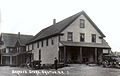
 Grafton Center c. 1909 | ||
|
FIPS code 33-30820 | | |
| GNIS feature ID | 0873609 | |
| Website | www | |
Grafton is a town in Grafton County, New Hampshire, United States. The population was 1,385 at the 2020 census.[3]
History
Originally granted in 1761, and re-granted in 1769, Grafton, like the county it resides in, takes its name from Augustus FitzRoy, 3rd Duke of Grafton,[4] a relative of colonial governor Benning Wentworth. Grafton was incorporated in 1778.
Historically, Grafton's economic base consisted of subsistence farming, small-scale industry, and mining. Several mica mines and granite quarries once dotted the town's landscape, most notably Ruggles Mine.
-
 The United Mica Company operated this mill between 1909 and 1916. Image c. 1909
 -
 In continuous operation since the 1840s, this store is now known as the Grafton Country Store. Image c. 1919.


Geography
The town is in western New Hampshire, on the southern edge of Grafton County. It is bordered to the south by
According to the
Climate
| Climate data for Grafton, 1991–2020 normals, 1893-2020 extremes: 830ft (253m) | |||||||||||||
|---|---|---|---|---|---|---|---|---|---|---|---|---|---|
| Month | Jan | Feb | Mar | Apr | May | Jun | Jul | Aug | Sep | Oct | Nov | Dec | Year |
| Record high °F (°C) | 60 (16) |
64 (18) |
80 (27) |
92 (33) |
95 (35) |
99 (37) |
99 (37) |
97 (36) |
95 (35) |
86 (30) |
74 (23) |
70 (21) |
99 (37) |
| Mean maximum °F (°C) | 48.5 (9.2) |
51.8 (11.0) |
63.5 (17.5) |
77.3 (25.2) |
84.8 (29.3) |
88.8 (31.6) |
90.7 (32.6) |
88.4 (31.3) |
83.8 (28.8) |
75.8 (24.3) |
66.3 (19.1) |
51.5 (10.8) |
92.0 (33.3) |
| Mean daily maximum °F (°C) | 29.1 (−1.6) |
31.9 (−0.1) |
40.2 (4.6) |
54.3 (12.4) |
65.7 (18.7) |
75.2 (24.0) |
79.5 (26.4) |
77.8 (25.4) |
70.8 (21.6) |
58.0 (14.4) |
45.4 (7.4) |
34.0 (1.1) |
55.2 (12.9) |
| Daily mean °F (°C) | 18.2 (−7.7) |
19.6 (−6.9) |
28.6 (−1.9) |
41.3 (5.2) |
52.8 (11.6) |
62.4 (16.9) |
66.8 (19.3) |
65.5 (18.6) |
57.7 (14.3) |
45.4 (7.4) |
35.3 (1.8) |
24.5 (−4.2) |
43.2 (6.2) |
| Mean daily minimum °F (°C) | 7.2 (−13.8) |
7.2 (−13.8) |
17.1 (−8.3) |
28.3 (−2.1) |
39.9 (4.4) |
49.5 (9.7) |
54.1 (12.3) |
53.2 (11.8) |
44.7 (7.1) |
32.8 (0.4) |
25.3 (−3.7) |
15.0 (−9.4) |
31.2 (−0.5) |
| Mean minimum °F (°C) | −18.7 (−28.2) |
−17.7 (−27.6) |
−8.2 (−22.3) |
15.2 (−9.3) |
24.2 (−4.3) |
32.2 (0.1) |
39.2 (4.0) |
36.1 (2.3) |
27.3 (−2.6) |
17.2 (−8.2) |
7.5 (−13.6) |
−8.0 (−22.2) |
−20.9 (−29.4) |
| Record low °F (°C) | −40 (−40) |
−36 (−38) |
−25 (−32) |
−6 (−21) |
14 (−10) |
25 (−4) |
30 (−1) |
26 (−3) |
16 (−9) |
9 (−13) |
−6 (−21) |
−30 (−34) |
−40 (−40) |
| Average precipitation inches (mm) | 2.93 (74) |
2.55 (65) |
3.05 (77) |
3.20 (81) |
3.18 (81) |
4.21 (107) |
3.89 (99) |
3.32 (84) |
3.23 (82) |
4.51 (115) |
3.11 (79) |
2.98 (76) |
40.16 (1,020) |
| Average snowfall inches (cm) | 22.1 (56) |
15.3 (39) |
15.5 (39) |
5.0 (13) |
0.0 (0.0) |
0.0 (0.0) |
0.0 (0.0) |
0.0 (0.0) |
0.0 (0.0) |
0.4 (1.0) |
4.8 (12) |
15.6 (40) |
78.7 (200) |
| Source 1: NOAA(1981-2010 Snowfall)[6][7] | |||||||||||||
| Source 2: XMACIS2 (records & 1981-2010 monthly max/mins)[8] | |||||||||||||
Demographics
| Census | Pop. | Note | %± |
|---|---|---|---|
| 1790 | 403 | — | |
| 1800 | 682 | 69.2% | |
| 1810 | 931 | 36.5% | |
| 1820 | 1,094 | 17.5% | |
| 1830 | 1,207 | 10.3% | |
| 1840 | 1,201 | −0.5% | |
| 1850 | 1,259 | 4.8% | |
| 1860 | 1,150 | −8.7% | |
| 1870 | 907 | −21.1% | |
| 1880 | 934 | 3.0% | |
| 1890 | 787 | −15.7% | |
| 1900 | 748 | −5.0% | |
| 1910 | 641 | −14.3% | |
| 1920 | 554 | −13.6% | |
| 1930 | 539 | −2.7% | |
| 1940 | 552 | 2.4% | |
| 1950 | 442 | −19.9% | |
| 1960 | 348 | −21.3% | |
| 1970 | 370 | 6.3% | |
| 1980 | 739 | 99.7% | |
| 1990 | 923 | 24.9% | |
| 2000 | 1,138 | 23.3% | |
| 2010 | 1,340 | 17.8% | |
| 2020 | 1,385 | 3.4% | |
| U.S. Decennial Census[3][9] | |||
As of the census of 2010, there were 1,340 people, 564 households, and 372 families residing in the town. The population density was 32.1 inhabitants per square mile (12.4/km2). There were 839 housing units at an average density of 20.1 per square mile (7.8/km2). The racial makeup of the town was 96.7%
There were 564 households, out of which 24.1% had children under the age of 18 living with them, 54.4% were headed by married couples living together, 7.1% had a female householder with no husband present, and 34.0% were non-families. 26.4% of all households were made up of individuals, and 7.4% consisted of someone living alone who was 65 years of age or older. The average household size was 2.38, and the average family size was 2.84.[10]
In the town, the population was spread out, with 18.8% under the age of 18, 5.2% from 18 to 24, 23.7% from 25 to 44, 36.5% from 45 to 64, and 14.6% who were 65 years of age or older. The median age was 45.6 years. For every 100 females, there were 108.7 males. For every 100 females age 18 and over, there were 112.1 males.[10]
At the 2000 census, the median income for a household in the town was $38,654, and the median income for a family was $41,875. Males had a median income of $30,074 versus $23,750 for females. The
Government
Grafton is governed by a three-person
Politics
Grafton County, within which the town of Grafton resides, ranks number 100 in terms of highest property taxes levied in the United States.[11] As of 2019, the town of Grafton itself has the 16th highest property tax rate in the state of New Hampshire.[12]
Free Town Project
In 2004, Grafton became the focus for
During this time, the town's population grew by about 200 people (about 20%); nearly all of the newcomers were men.

The project has been associated with an increase in the number and aggressiveness of black bears in town, including entering homes, mauling people, and eating pets.[14] A single, definitive cause for the abnormal behavior of the bears has not been proven, but it may be due to libertarian residents who refuse to buy and use bear-resistant containers, who do not dispose of waste materials (such as feces) safely, or who deliberately put out food to attract the bears to their own yards, without caring how this affected other people.[14]
After a rash of lawsuits from Free Towners, an influx of sex offenders, an increase of crime, problems with bold local bears, and the first murders in the town's history, the Libertarian project ended in 2016.[13][14][18]
Notable people
- Monroe Heath (1827–1894), mayor of Chicago from 1876 to 1879
- Myra Belle Martin (1861–?), teacher, writer, financier in late 19th century and early 20th century
- Cyrus A. Sulloway (1839–1917), congressman
Sites of interest
- Ruggles Mine (closed)
References
- ^ "Board of Selectmen". Town of Grafton, New Hampshire. Retrieved July 18, 2023.
- ^ a b "2021 U.S. Gazetteer Files – New Hampshire". United States Census Bureau. Retrieved November 23, 2021.
- ^ a b c "Grafton town, Grafton County, New Hampshire: 2020 DEC Redistricting Data (PL 94-171)". U.S. Census Bureau. Retrieved November 23, 2021.
- ^ Gannett, Henry (1905). The Origin of Certain Place Names in the United States. Govt. Print. Off. p. 140.
- ^ Foster, Debra H.; Batorfalvy, Tatianna N.; Medalie, Laura (1995). Water Use in New Hampshire: An Activities Guide for Teachers. U.S. Department of the Interior and U.S. Geological Survey.
- ^ "Grafton, New Hampshire 1991-2020 Monthly Normals". Retrieved December 15, 2023.
- ^ "Grafton, New Hampshire 1981-2010 Monthly Normals". Retrieved December 15, 2023.
- ^ "xmACIS". National Oceanic and Atmospheric Administration. Retrieved December 15, 2023.
- ^ "Census of Population and Housing". Census.gov. Retrieved June 4, 2016.
- ^ a b c "Profile of General Population and Housing Characteristics: 2010 Demographic Profile Data (DP-1): Grafton town, Grafton County, New Hampshire". United States Census Bureau. Retrieved July 10, 2012.
- ^ "Grafton County New Hampshire Property Taxes - 2020". Retrieved October 16, 2020.
- ^ "New Hampshire 2019 Property Tax Rates | NH Town Property Taxes". joeshimkus.com. Retrieved October 16, 2020.
- ^ a b c Illing, Sean (December 10, 2020). "How a New Hampshire libertarian utopia was foiled by bears". Vox.
- ^ from the original on October 13, 2020. Retrieved June 16, 2021.
- ^ a b Hongoltz-Hetling, Matthew (May 2018). "Barbearians at the Gate: A journey through a quixotic New Hampshire town teeming with libertarians, fake news, guns, and—possibly—furry invaders". Atavist. No. 79. Archived from the original on June 16, 2018. Retrieved June 16, 2021.
- ISBN 9781541788510.
- ^ https://www.vox.com/policy-and-politics/21534416/free-state-project-new-hampshire-libertarians-matthew-hongoltz-hetling
- ^ Austin, Elizabeth (August 30, 2020). "Libertarians Took Control of This Small Town. It Didn't End Well". Washington Monthly. Retrieved July 21, 2023.
External links
 Media related to Grafton, New Hampshire at Wikimedia Commons
- Official website
- New Hampshire Economic and Labor Market Information Bureau Profile
Places adjacent to Grafton, New Hampshire | |
|---|---|
 | ||||
| Towns |
| |||
| Township | ||||
| CDPs | ||||
Other villages | ||||
| ||||
| International | |
|---|---|
| National | |