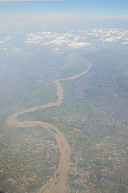
Hindon River
| Hindon River | |
|---|---|
 Aerial view of river Hindon, Ghaziabad | |
| Location | |
| Country | India |
| Region | Uttar Pradesh |
| Physical characteristics | |
| Source | Rajaji Range, Sivalik Hills |
| • location | Saharanpur district, Uttar Pradesh |
| • coordinates | 35°05′N 77°08′E / 35.083°N 77.133°E |
| Mouth | Yamuna river |
• location | Sector-150, Noida, India |
• coordinates | 28°24′50″N 77°29′46″E / 28.41389°N 77.49611°E |
| Length | 400 km (250 mi) |
| Basin size | 7,083 km2 (2,735 sq mi) |
Hindon River is an Indian river in that originates from the Shakumbhari devi range (
It flows between Ganges and Yamuna rivers for 400 kilometres (250 mi) through
Tributary
The
Mythology
Near
History
An
During 1857–58, Ghaziabad city was a scene of fighting during the
Hindon Vahini
The industries of western Uttar Pradesh discharge their effluents, often with no treatment, directly into the Hindon River.[citation needed] This heavy loading characterizes the presence of toxic contaminants and for the biological diversity of river ecology. Dissolved oxygen levels are zero throughout the length of this river.
But now many NGOs have come forward to rejuvenate this river. Abhiyans like Hindon Kali and Krishna Bachao Abhiyan are held by locals. NGOs with RWA are working to aware local and trying to remove solid non-biodegradable wastes like plastic from the river. Now, farming is reducing chemical fertilizes and pesticides near the flood plains.[1]
References
- ^ ISBN 978-1-4020-5179-1.
- ^ Hindon Air Base GlobalSecurity.org
- ^ Epic Proportion: Sardhana - There’s more to Sardhana than the church.. The Economic Times, 6 March 2008.
- ^ A. Ghosh (ed.). "Excavations at Alamgirpur". Indian Archaeology, A Review (1958-1959). Delhi: Archaeol. Surv. India. pp. 51–52.
