
Jackson, New Hampshire
Jackson, New Hampshire | ||
|---|---|---|
Town | ||
 | ||
|
FIPS code 33-38260 | | |
| GNIS feature ID | 0873632 | |
| Website | www | |
Jackson is a
History

Once consisting of several large land grants by colonial Governor
In 1847, artists of the
The increasing use of
-
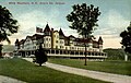
 Wentworth Hall c. 1912
 -
 Thorn Mountain in 1912
 -
 Gray's Inn in 1907
 -
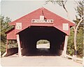 Honeymoon Bridge in October 1982


Geography
According to the United States Census Bureau, the town has a total area of 66.8 square miles (173.0 km2), of which 0.04 square miles (0.1 km2), or 0.06%, are water.[1] Jackson is drained by the Ellis River and its tributary Wildcat Brook. The highest point in Jackson is 3,870 feet (1,180 m) above sea level on Wildcat Ridge, at the northern boundary of town. The ridge continues to rise north of the town border to the summit of Wildcat Mountain—4,422 ft (1,348 m)—in the neighboring township of Bean's Purchase. Jackson lies fully within the Saco River watershed.[7]
Adjacent municipalities
- Bean's Purchase (north)
- Chatham (east)
- Bartlett (south)
- Sargent's Purchase (west)
- Pinkham's Grant (northwest)
Demographics
| Census | Pop. | Note | %± |
|---|---|---|---|
| 1850 | 589 | — | |
| 1860 | 631 | 7.1% | |
| 1870 | 474 | −24.9% | |
| 1880 | 464 | −2.1% | |
| 1890 | 579 | 24.8% | |
| 1900 | 624 | 7.8% | |
| 1910 | 452 | −27.6% | |
| 1920 | 533 | 17.9% | |
| 1930 | 321 | −39.8% | |
| 1940 | 409 | 27.4% | |
| 1950 | 344 | −15.9% | |
| 1960 | 315 | −8.4% | |
| 1970 | 404 | 28.3% | |
| 1980 | 642 | 58.9% | |
| 1990 | 678 | 5.6% | |
| 2000 | 835 | 23.2% | |
| 2010 | 816 | −2.3% | |
| 2020 | 1,028 | 26.0% | |
| U.S. Decennial Census[2][8] | |||

As of the
There were 377 households, out of which 21.0% had children under the age of 18 living with them, 57.8% were married couples living together, 5.0% had a female householder with no husband present, and 36.1% were non-families. 27.1% of all households were made up of individuals, and 10.3% had someone living alone who was 65 years of age or older. The average household size was 2.18 and the average family size was 2.67.

In the town, the population was spread out, with 18.0% under the age of 18, 2.2% from 18 to 24, 28.7% from 25 to 44, 29.3% from 45 to 64, and 21.8% who were 65 years of age or older. The median age was 46 years. For every 100 females, there were 99.3 males. For every 100 females age 18 and over, there were 99.1 males.
The median income for a household in the town was $49,583, and the median income for a family was $59,327. Males had a median income of $32,813 versus $26,667 for females. The
References
- ^ a b "2021 U.S. Gazetteer Files – New Hampshire". United States Census Bureau. Retrieved November 1, 2021.
- ^ a b c "Jackson town, Carroll County, New Hampshire: 2020 DEC Redistricting Data (PL 94-171)". U.S. Census Bureau. Retrieved November 1, 2021.
- ^ United States Census Bureau, American FactFinder, 2010 Census figures. Retrieved March 23, 2011.
- ^ McKenzie, Margaret (May 17, 2021). "Jackson voters rededicate town, ban fireworks". The Conway Daily Sun. Retrieved November 1, 2021.
- ^ "About – Jackson XC". Retrieved August 25, 2022.
- ^ Brooks, David (September 24, 2019). "Vail completes purchase of Crotched, Wildcat and Attitash ski areas in N.H." Concord Monitor. Retrieved August 8, 2022.
- ^ Foster, Debra H.; Batorfalvy, Tatianna N.; Medalie, Laura (1995). Water Use in New Hampshire: An Activities Guide for Teachers. U.S. Department of the Interior and U.S. Geological Survey.
- ^ "Census of Population and Housing". Census.gov. Retrieved June 4, 2016.
- ^ "U.S. Census website". United States Census Bureau. Retrieved January 31, 2008.
External links
- Official website
- Jackson Historical Society
- New Hampshire Economic and Labor Market Information Bureau Profile
- Jackson Area Chamber of Commerce
Places adjacent to Jackson, New Hampshire | |
|---|---|
Municipalities and communities of Carroll County, New Hampshire, United States | ||
|---|---|---|
| Towns |  | |
| Township | ||
| CDPs | ||
Other villages | ||
| ||
| International | |
|---|---|
| National | |