
Murguma Dam
| Murguma Dam | |
|---|---|
Purulia District, West Bengal, India | |
| Coordinates | 23°18′50″N 86°03′00″E / 23.314°N 86.050°E |
| Dam and spillways | |
| Impounds | Saharajhore River |
| Website https://www.palashbitan.com/about-murguma.php | |
The Murguma Dam
People and economy
The area is basically inhabited by tribal people,[5][1] mainly Santal people.[6] The economy is mainly dependent on agriculture.[7] However, the place has a good potentiality to be a popular tourist spot which can improve economic condition of the local people. The government is promoting this place as a tourist destination.[3] This dam is a part of one of the key small irrigation projects[8] in rural as well as arid areas of West Bengal[2][6] having a considerable percentage of tribal population.[6][5] It is one of the promising tourist spots of Eastern Chota Nagpur Plateau region. Till date, no facility of boating offered. The dam and surroundings are preferred locations for backpackers.[9] The dam features in the tourism brochure of Government Tourist Department of Purulia District.[10]
Accessibility
The nearest railway station is Jhalda, from where the place is accessible by single metaled road. The other option is to follow the Purulia-Tamna more-Arsha-Begunkodor-Murguma(50 km) route. The accessibility is somehow not so good but that is perhaps one of the reasons that the place still offers wild beauty.
Distance from nearby places: Ajodhya Hills Top = 20 km, Jhalda = 16 km, Begunkodor town = 6 km, Begunkodar rail FH = 12 km, Kolkata = 340 km, Purulia = 50 km, Durgapur = 185 km (via Bankura) 165 km (via Asansol), Bankura = 140 km, Jamshedpur = 110 km, Ranchi = 95 km, Asansol = 134 km,
Miscellaneous
Being far from urban disturbance, this dam is a location for research on indigenous aquatic flora[11][12] and fauna.[13] This area was affected by Maoist insurgency a few years back but now returned to normalcy.[14]
Gallery
-
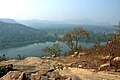
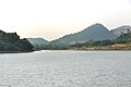
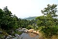
 View from Ajodhya Hill
 -
 View from Ajodhya Hill
 -
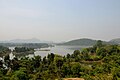 View from Ajodhya Hill
 -
 View from Ajodhya Hill
 -
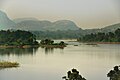
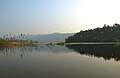
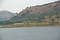
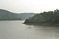
 View of Murguma Dam and Murguma Village from Ajyodhya Hill View Point
 -
 View of Murguma Dam and Murguma Village from Ajyodhya Hill View Point
 -
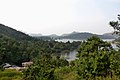
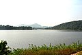
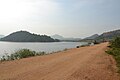
 View of Murguma Dam
 -
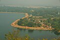
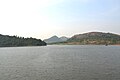
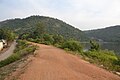
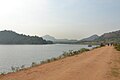
 View from Dam Road
 -
 View from Dam Road
 -
 View from Dam Road
 -
 View from Dam Road
 -
 View from Dam Road
 -
 Murguma Village and the Dam side by side
 -
 View from Dam Road
 -
 View from Dam Road
 -
 View from Dam Road
 -
 View from Sluice Gate
 -
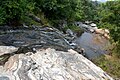 A stream coming from Ajodhya Hill
 -
 A stream coming from Ajodhya Hill
 -
 A stream coming from Ajodhya Hill


References
- ^ a b "PURULIA - Attractions & activities - West Bengal Tourism, Experience Bengal, Dept. of Tourism, Govt. of W. B." www.wbtourismgov.in.
- ^ a b Ray, Sutapa (January 7, 1985). "Terrain analysis of the kangsabati basin and its impact on land use". University – via shodhganga.inflibnet.ac.in.
- ^ a b "The Official Website of Purulia District". purulia.nic.in.
- ^ "Murguma Dam". wikimapia.org.
- ^ a b "Murguma | Discovery World Tours".
- ^ a b c "Data" (PDF). censusindia.gov.in. 2011. Retrieved 2021-04-03.
- ^ "MURGUMA Village BEGUN KODAR Panchayat JHALDA II Block, PURULIA, West Bengal India BrandBharat.com".
- ^ "Irrigation Bunglow - Murguma". wikimapia.org.
- ^ "Muruguma dam - Purulia:The Best Weekend Getaway from Kolkata". September 10, 2019.
- ^ "Tourism brochure" (PDF). purulia.gov.in. Retrieved 2021-04-03.
- ^ "Riverine_Plants_of_Kansai_Basin" (PDF). www.researchgate.net. Retrieved 2021-04-03.
- ^ "Taxonomic_Observations_on_Epithemia_adnata" (PDF). www.researchgate.net. Retrieved 2021-04-03.
- ^ "Ichthyofaunal_diversity" (PDF). www.researchgate.net. Retrieved 2021-04-03.
- ^ "IAP_improving_lives". www.researchgate.net. Retrieved 2021-04-03.