
Parvati River (Himachal Pradesh)
This article needs additional citations for verification. (June 2016) |

Parvati River is a
Pin Parbati Pass and flows in a gradual curve from north-northwest to west-southwest past the important temple town of Manikaran.[1]
The river valley has been a route to various places: Lahul across the Sara Umga La pass, Spiti across the famous Pin Parbati Pass, and the recently discovered (1995) Debsa Pass. The river has fine first-growth forests in its upper reaches which are being degraded as a consequence of development of its vast hydro-electric potential. There are geothermal springs on the banks of the river at Manikaran and Kheerganga.
Gallery
-
 The Fast Flowing Parvati River on the banks of Kasol, Himachal Pradesh
 -
 Parvati river flowing in sweeping meanders, Kasol.
 -
 Parvati River
 -
 Parvati River, Kasol
 -
 Parvati River, Jia Bride, Kullu
 -
 River Beas and River Parvati
 -
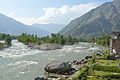
 Parvati River near Kasol town


External links
![]() Media related to Parvati River (Himachal Pradesh) at Wikimedia Commons
Media related to Parvati River (Himachal Pradesh) at Wikimedia Commons
References
- ISBN 9788185182612.
31°53′33″N 77°11′00″E / 31.89250°N 77.18333°E
| International | |
|---|---|
| National | |
| Rivers |
|
|---|---|
| Lakes |
|
| Dams, barrages | |
This Himachal Pradesh location article is a stub. You can help Wikipedia by expanding it. |