
Santiago
Santiago | |
|---|---|
Metropolitan Cathedral of Santiago | |
 Flag .svg) Coat of arms
UTC−3 (CLST) | |
| Postal code | 8320000 |
| Area code | +56 2 |
| HDI (2021) | 0.886[2] – very high |
| Website | www |

Santiago (
Founded in 1541 by the Spanish conquistador Pedro de Valdivia, Santiago has served as the capital city of Chile since colonial times.[5] The city has a downtown core of 19th-century neoclassical architecture and winding side-streets featuring a mix of art deco, neo-gothic, and other styles. Santiago's cityscape is defined by several stand-alone hills and the fast-flowing Mapocho River, which is lined by parks such as Parque Forestal and Balmaceda Park. The Andes Mountains can be seen from most parts of the city and contribute to a smog problem, particularly during winter, due to the lack of rain. The outskirts of the city are surrounded by vineyards, and Santiago is within an hour's drive of both the mountains and the Pacific Ocean.
Santiago is the political and financial center of Chile and is home to the regional headquarters of many multinational corporations. The Chilean government's executive and judiciary branches are based in Santiago, while the Congress mostly meets in nearby Valparaíso.
Nomenclature
In Chile, there are several entities that share the name "Santiago" and can often lead to confusion. The
When the term "Santiago" is used without additional clarification, it typically refers to Greater Santiago (Gran Santiago), the metropolitan area defined by its continuous urban development. This area encompasses the Commune of Santiago and over 40 other communes, making up the majority of the Santiago Province and parts of neighboring provinces (see Political divisions). The definition of the metropolitan area has changed over time as a result of the city's expansion and the incorporation of smaller cities and rural areas.
The name "Santiago" was chosen by the Spanish conqueror Pedro de Valdivia, when he founded the city in 1541, as a tribute to James the Great, the patron saint of Spain. The name of this saint is rendered differently in Spanish, such as Diego, Jaime, Jacobo or Santiago, with the latter being derived from the Galician evolution of Vulgar Latin Sanctu Iacobu. There was no indigenous name for the area where Santiago is located, but the Mapuche language uses the adapted name "Santiaw."
When Valdivia founded the city, he named it "Santiago del Nuevo Extremo" or "
The residents of the city and region are referred to as santiaguinos (male) and santiaguinas (female).
History
Prehistory
Archaeological evidence suggests that the first human groups arrived in the Santiago basin around the
The villages belonging to the
Founding of the city

Painting by Pedro Lira, the portrait of Pedro de Valdivia and Juan Martín de Candia;[6] proclaiming the City of Santiago de Chile, c. 1541
On 12 February 1541, Valdivia officially founded the city of Santiago del Nuevo Extremo (Santiago of New Extremadura), in honor of the Apostle James, patron saint of Spain, near Huelén, which he renamed Santa Lucía. He tasked the city's layout to master builder Pedro de Gamboa, who created a grid design for the city. In the center of the city, Gamboa designed a Plaza Mayor, which served as the central hub for the town. Plots for the cathedral, the jail and the governor's house were also selected around the plaza. The city was divided into eight blocks from north to south and ten blocks from east to west, with each quarter-block or "solar" being given to the settlers. The settlers then built homes made of mud and straw.
Valdivia left for the south with his troops months later, starting the
During the early years of the city, the Spanish suffered from severe shortages of food and other supplies. The local indigenous Picunche had adopted a strategy of halting cultivation and retreating to more remote locations,[7] which isolated the Spanish and forced them to resort to eating whatever they could find. The shortage of clothing meant that some Spanish had to dress with hides from dogs, cats, sea lions, and foxes.[7]
Colonial Santiago


Although Santiago was facing the threat of permanent destruction early on, due to attacks from indigenous peoples, earthquakes, and floods, the city began to grow rapidly. Out of the 126 blocks designed by Pedro de Gamboa in 1558, 40 were occupied. In 1580, the first major buildings in the city started to be erected, marked by the placement of the foundation stone of the first Cathedral in 1561 and the building of the church of San Francisco in 1572. Both of these structures were primarily made of adobe and stone. In addition to the construction of significant buildings, the city began to thrive as the surrounding areas welcomed tens of thousands of livestock.
During the 16th and 17th centuries, the growth of the city was hindered by a series of disasters including an earthquake, a smallpox epidemic in 1575, the Mapocho River floods in 1590, 1608, and 1618, and a devastating earthquake on 13 May 1647 which resulted in the death of over 600 people and affected over 5,000 others. Despite these setbacks, the capital of the Captaincy General of Chile continued to grow, with all the power of the country being centered on the Plaza de Armas in Santiago.
In 1767, the corregidor Luis Manuel de Zañartu launched one of the most significant architectural projects of the colonial period, the Calicanto Bridge, connecting the city to La Chimba on the north side of the Mapocho River. He also began constructing
-
![The colonial La Cañada neighborhood in Santiago de Chile, in 1821, by Scharf and Schmidtmeyer. John Carter Brown Library.[8][9]](//upload.wikimedia.org/wikipedia/commons/thumb/0/0a/Schmidtmeyer%2C_Peter_%26_Scharf%2C_G_-_The_Ca%C3%B1ada%2C_Santiago_-JCB_Library_f1_%28cropped%29.jpg/308px-Schmidtmeyer%2C_Peter_%26_Scharf%2C_G_-_The_Ca%C3%B1ada%2C_Santiago_-JCB_Library_f1_%28cropped%29.jpg) The colonial La Cañada neighborhood in Santiago de Chile, in 1821, by Scharf and Schmidtmeyer. John Carter Brown Library.[8][9]
The colonial La Cañada neighborhood in Santiago de Chile, in 1821, by Scharf and Schmidtmeyer. John Carter Brown Library.[8][9] -
![Scenes at a fair in Santiago de Chile, in 1821, by Scharf and Schmidtmeyer. John Carter Brown Library.[8][10]](//upload.wikimedia.org/wikipedia/commons/thumb/b/ba/Schmidtmeyer%2C_Peter_%26_Scharf%2C_G_-_Scenes_at_a_Fair_-JCB_Library_f1.2.jpg/331px-Schmidtmeyer%2C_Peter_%26_Scharf%2C_G_-_Scenes_at_a_Fair_-JCB_Library_f1.2.jpg) Scenes at a fair in Santiago de Chile, in 1821, by Scharf and Schmidtmeyer. John Carter Brown Library.[8][10]
Scenes at a fair in Santiago de Chile, in 1821, by Scharf and Schmidtmeyer. John Carter Brown Library.[8][10] -
![The colonial Real Casa de la Moneda (now called Palacio de la Moneda) in 1824 (by Paroissien, Scharf and Rowney & Forster). John Carter Brown Library.[11]](//upload.wikimedia.org/wikipedia/commons/thumb/3/3c/Schmidtmeyer-_Paroissien%2C_James_%26_Scharf%2C_G_-_The_Mint_of_Santiago_-JCB_Library_f1.3.jpg/339px-Schmidtmeyer-_Paroissien%2C_James_%26_Scharf%2C_G_-_The_Mint_of_Santiago_-JCB_Library_f1.3.jpg) The colonialReal Casa de la Moneda (now called Palacio de la Moneda) in 1824 (by Paroissien, Scharf and Rowney & Forster). John Carter Brown Library.[11]
The colonialReal Casa de la Moneda (now called Palacio de la Moneda) in 1824 (by Paroissien, Scharf and Rowney & Forster). John Carter Brown Library.[11] -
![[Colonial] Plaza o great Square of Santiago with different local costumes, in 1826, by John Miers. British Library.[12][13]](//upload.wikimedia.org/wikipedia/commons/thumb/0/05/Plaza_o_great_Square_of_Santiago_with_diffent_national_costumes_%28cropped2%29.jpg/426px-Plaza_o_great_Square_of_Santiago_with_diffent_national_costumes_%28cropped2%29.jpg) [Colonial] Plaza o great Square of Santiago with different local costumes, in 1826, by John Miers. British Library.[12][13]
[Colonial] Plaza o great Square of Santiago with different local costumes, in 1826, by John Miers. British Library.[12][13] -
![[Colonial] Square in Downtown Santiago, in 1850, by the French-born Ernest Charton.[14][15]](//upload.wikimedia.org/wikipedia/commons/thumb/6/6e/Plaza_de_Armas_de_Santiago_de_Chile_en_1850.jpg/256px-Plaza_de_Armas_de_Santiago_de_Chile_en_1850.jpg)
-
![Colonial Plaza de Armas de Santiago in 1854 by Claude Gay.[16] In the foreground you can see the still intact Palace of the Real Audiencia of Chile, and in the background the unfinished Cathedral, both built by the Italian Joaquin Toesca.](//upload.wikimedia.org/wikipedia/commons/thumb/e/ea/Plaza_de_la_Independencia_de_Santiago_in_1854_by_Claude_Gray.jpg/341px-Plaza_de_la_Independencia_de_Santiago_in_1854_by_Claude_Gray.jpg) Colonial Plaza de Armas de Santiago in 1854 byJoaquin Toesca.
Colonial Plaza de Armas de Santiago in 1854 byJoaquin Toesca. -
 Colonial Plaza de Armas de Santiago in 1859 by Joseph Selleny aboard the Novara expedition, to the left, the (beginning to be modified) Palace of the Real Audiencia of Chile, and to the right, the colonial Portal de Sierra Bella.
 -
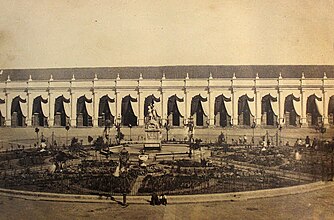 Portal de Sierra Bella and gardens of the Plaza de Armas in 1860. The colonial imprint was maintained until well into the 19th century, this commercial portal faithfully reflects the appearance of colonial Santiago. Photograph by Eugéne Maunoury, belonging to the Bibliothèque nationale de France.
![The colonial La Cañada neighborhood in Santiago de Chile, in 1821, by Scharf and Schmidtmeyer. John Carter Brown Library.[8][9]](/File:Schmidtmeyer,_Peter_%26_Scharf,_G_-_The_Ca%C3%B1ada,_Santiago_-JCB_Library_f1_(cropped).jpg)
![Scenes at a fair in Santiago de Chile, in 1821, by Scharf and Schmidtmeyer. John Carter Brown Library.[8][10]](/File:Schmidtmeyer,_Peter_%26_Scharf,_G_-_Scenes_at_a_Fair_-JCB_Library_f1.2.jpg)
![The colonial Real Casa de la Moneda (now called Palacio de la Moneda) in 1824 (by Paroissien, Scharf and Rowney & Forster). John Carter Brown Library.[11]](/File:Schmidtmeyer-_Paroissien,_James_%26_Scharf,_G_-_The_Mint_of_Santiago_-JCB_Library_f1.3.jpg)
![[Colonial] Plaza o great Square of Santiago with different local costumes, in 1826, by John Miers. British Library.[12][13]](/File:Plaza_o_great_Square_of_Santiago_with_diffent_national_costumes_(cropped2).jpg)
![[Colonial] Square in Downtown Santiago, in 1850, by the French-born Ernest Charton.[14][15]](/File:Plaza_de_Armas_de_Santiago_de_Chile_en_1850.jpg)
![Colonial Plaza de Armas de Santiago in 1854 by Claude Gay.[16] In the foreground you can see the still intact Palace of the Real Audiencia of Chile, and in the background the unfinished Cathedral, both built by the Italian Joaquin Toesca.](/File:Plaza_de_la_Independencia_de_Santiago_in_1854_by_Claude_Gray.jpg)


Capital of the Republic

On 18 September 1810, the
Although institutions like the

With the end of the war,
Two earthquakes struck the city in the 19th century, one on 19 November 1822, and another on 20 February 1835. Despite these disasters, the city continued to grow rapidly. In 1820, the population was recorded as 46,000, but by 1854, it had risen to 69,018. By 1865, the census reported 115,337 residents. This significant increase was due to suburban expansion to the south and west of the capital, as well as the growth of the bustling district of La Chimba, which resulted from the division of old properties in the area. This new peripheral development marked the end of the previous checkerboard structure that dominated the city center.
19th century

During the Republican era, several institutions were founded, including the University of Chile, the Normal School of Preceptors, the School of Arts and Crafts, and the Quinta Normal. The latter comprised the Museum of Fine Arts (now the Museum of Science and Technology) and the National Museum of Natural History. These institutions were established primarily for educational purposes, but also served as examples of public planning during that period. In 1851, the first telegraph system connecting the capital to the Port of Valparaíso was inaugurated.[17]
During the "Liberal Republic" and the administration of Mayor
Also during this era,

Santiago emerged as the central hub of the national railway system. On 14 September 1857, the first railway arrived in the city and terminated at the
The centennial Santiago
Le Monde Illustré .
As the new century began, Santiago underwent various changes due to the rapid growth of industry. Valparaíso, which had previously been the economic center of the country, gradually lost its prominence to the capital. By 1895, 75% of the national manufacturing industry was located in Santiago, while only 28% was in Valparaíso. By 1910, major banks and shops had established themselves in the central streets of Santiago, further diminishing the role of Valparaíso. The enactment of the Autonomous Municipalities Act empowered municipalities to establish various administrative divisions within the Santiago department, with the goal of enhancing local governance. In 1891, the municipalities of Maipú, Ñuñoa, Renca, Lampa, and Colina were created, followed by Providencia and Barrancas in 1897, and Las Condes in 1901. The La Victoria departmento was also divided, leading to the creation of Lo Cañas in 1891, which was then further split into La Granja and Puente Alto in 1892, followed by La Florida in 1899, and La Cisterna in 1925. The Virgin Mary . Today, the statue is visible from various points in the city. However, the shrine was not completed until several decades later.
The 1910 Chile Centennial celebrations marked the beginning of several urban development projects. The railway network was expanded, connecting the city and its growing suburbs with a new ring and route to National Library were opened. In addition, a sewer system was installed, serving approximately 85% of the city's population.
Population explosion The 1920 census estimated the population of Santiago to be 507,296 inhabitants, equivalent to 13.6% of the total population of Chile. This represented a growth of 52.5% from the 1907 census, an annual increase of 3.3%, which was almost three times the national average. This growth was mainly due to an influx of farmers from the southern regions who came to work in the factories and railroads that were being built. However, this growth was concentrated in the suburbs and not in the city center. .jpg)  During this time, the downtown district consolidated as a commercial, financial, and administrative center, with the establishment of various shops and businesses around Ahumada Street and a Civic District in the vicinity of the Palace of La Moneda. The latter project involved the construction of modernist buildings for the offices of the ministries and other public services, as well as the start of the construction of medium-rise buildings. Meanwhile, the traditional residents of the center began to migrate to more rural areas like Providencia and Ñuñoa, which attracted the oligarchy and European immigrant professionals, and San Miguel for middle-class families. Additionally, in the periphery, villas were built by various organizations of the time. Modernity also spread in the city, with the introduction of the first theaters, the expansion of the telephone network, and the opening of Los Cerrillos Airport in 1928, among other advancements.  The perception that the early 20th century was a time of economic prosperity due to technological advancements was in stark contrast to the living conditions of lower social classes. The previous decades of growth resulted in an unprecedented population boom starting in 1929, but was met with tragedy as the Great Depression hit. The collapse of the nitrate industry in the north left 60,000 people unemployed, compounded by a decline in agricultural exports, resulting in an estimated 300,000 unemployed people nationwide. Desperate for survival, many migrants flocked to Santiago and its thriving industry. However, they often found themselves struggling to find housing, with many being forced to live on the streets. The harsh living conditions resulted in widespread diseases like tuberculosis, and took a toll on the homeless population. At the same time, unemployment rates and living costs skyrocketed, while the salaries of the people in Santiago fell. La Alameda in 1930.The situation would change several years later with a new industrial boom fostered by CORFO and the expansion of the state apparatus from the late 1930s. At this time, the aristocracy lost much of its power, and the middle class, composed of merchants, bureaucrats, and professionals, acquired the role of setting national policy. In this context, Santiago began to develop a substantial middle- and lower-class population, while the upper classes sought refuge in the districts of the capital. Thus, the old moneyed class, who previously frequented Cousiño and Alameda Park, lost their hegemony over popular entertainment venues, and the National Stadium emerged in 1938. Greater Santiago
In the following decades, Santiago continued to grow at an unprecedented rate. In 1940, the city had a population of 952,075 residents, which increased to 1,350,409 by 1952, and reached 1,907,378 in the 1960 census. This growth was reflected in the urbanization of rural areas on the outskirts of the city, where middle and lower-class families with stable housing were established. In 1930, the urban area covered 6,500 hectares, which increased to 20,900 in 1960 and to 38,296 in 1980. Although growth was mainly concentrated in communities such as Barrancas to the west, La Reina sector.
The regulation of growth in Santiago only began in the 1960s with the creation of various development plans for Greater Santiago, a concept that reflected the city's new reality as a much larger urban center. In 1958, the Intercommunal Plan of Santiago was released, which proposed a limit of 38,600 urban and semi-urban hectares for a maximum population of 3,260,000 residents. The plan also included plans for the construction of new avenues, such as the Américo Vespucio Avenue and Panamericana Route 5, as well as the expansion of 'industrial belts'. The 1962 World Cup provided a new impetus for city improvement efforts, and in 1966, the Santiago Metropolitan Park was established on Cerro San Cristóbal. The Ministry of Housing and Urbanism (MINVU) also began to eradicate shantytowns and build new homes. Finally, the Edificio Diego Portales was constructed in 1972.  In 1967, the new Pudahuel International Airport was opened, and after years of discussion, construction of the Santiago Metro began in 1969. The first phase of the Metro, which ran beneath the western section of Alameda, was opened in 1975 and soon became one of the most prestigious buildings in the city. Over the following years, the Metro continued to expand, with two perpendicular lines in place by the end of 1978. Building telecommunications infrastructure was also an important development of this period, as reflected in the construction of the Torre Entel, which, since its construction in 1975, has become one of the symbols of the capital and remained the tallest structure in the country for two decades. After the military military regime, significant changes in urban planning did not occur until the 1980s when the government embraced a neoliberal economic model. In 1979, the master plan was revised, expanding the urban area to over 62,000 hectares for real estate development. This led to urban sprawl, particularly in La Florida, causing the city to reach 40,619 hectares in size in the early 1990s. According to the 1992 census, Santiago became the country's most populous municipality, with 328,881 residents. Tragically, a powerful earthquake struck the city on 3 March 1985, causing minimal casualties but leaving many homeless and destroying numerous historic buildings.
The metropolis in the early twenty-first century.jpg) Sky Costanera in 2018 , both established in 1981 and 1991, respectively.
With the onset of the transition to democracy in 1990, the city of Santiago surpassed four million inhabitants, with the majority residing in the south, particularly in La Florida, which was the most populous area, followed by Puente Alto and Maipú. The real estate development in these municipalities, as well as in others such as Quilicura and Peñalolén, was largely driven by the construction of housing projects for middle-class families. Meanwhile, high-income families relocated to the foothills, now commonly referred to as Barrio Alto, boosting the population of Las Condes and giving rise to young communes, including Lo Barnechea and Vitacura The area around Providencia Avenue became an important commercial hub in the eastern sector. This development extended to the Barrio Alto, which became an attractive location for the construction of high-rise buildings. Major companies and financial corporations established themselves in the area, giving rise to a thriving modern business center commonly known as Sanhattan. The departure of these companies to Barrio Alto and the construction of shopping centers all around the city created a crisis in the city center. To reinvigorate the area, the government transformed the main shopping streets into pedestrian walkways, as it did in the 1970s, and offered tax benefits for the construction of residential buildings, which attracted young adults. The city faced a series of problems due to disorganized growth. During the winter months, Transantiago was established, although it has faced various challenges since its implementation.
.jpg) Entering the 21st century, rapid development continued in Santiago. The Civic District was revitalized with the creation of the Gran Torre Santiago skyscrapers in the Costanera Center complex.
On 27 February 2010, a powerful earthquake hit the capital city of Santiago, causing damage to some older buildings and rendering some modern structures uninhabitable. This sparked a heated discussion about the actual implementation of mandatory earthquake standards in the city's modern architecture. Despite urban integration efforts, socioeconomic inequality and geosocial fragmentation remain two of the most important problems, both in the city and in the country. These problems have been considered one of the factors that led to the " Geography The city lies in the center of the Santiago Basin, a large bowl-shaped valley consisting of broad and fertile lands surrounded by mountains. The city has a varying elevation, gradually increasing from 400 m (1,312 ft) in the western areas to more than 700 m (2,297 ft) in the eastern areas. Santiago's international airport, in the west, lies at an altitude of 460 m (1,509 ft). Plaza Baquedano, near the center, lies at 570 m (1,870 ft). Estadio San Carlos de Apoquindo, at the eastern edge of the city, has an elevation of 960 m (3,150 ft). The Santiago Basin is part of the Cerro Santa Lucía. The basin is approximately 80 kilometers (50 miles) in a north–south direction and 35 km (22 mi) from east to west. The Mapocho River flows through the city.
The city is flanked by the main chain of the Chilean Coastal Range to the west. On the north, it is bordered by the Cordón de Chacabuco, a mountain range of the Andes. At the southern border lies the Angostura de Paine, an elongated spur of the Andes that almost reaches the coast.
The mountain range immediately bordering the city on the east is known as the Sierra de Ramón, which was formed due to tectonic activity of the San Ramón Fault. This range reaches 3296 meters at Cerro de Ramón. The Sierra de Ramón represents the "Precordillera" of the Andes. 20 km (12 mi) further east is the even larger Cordillera of the Andes, which has mountains and volcanoes that exceed 6,000 m (19,690 ft) and on which some glaciers are present. The tallest is the Tupungato mountain at 6,570 m (21,555 ft). Other mountains include Tupungatito, San José, and Maipo. Cerro El Plomo is the highest mountain visible from Santiago's urban area. During recent decades, urban growth has outgrown the boundaries of the city, expanding to the east up the slopes of the Andean Precordillera. In areas such as La Dehesa, Lo Curro, and El Arrayan, urban development is present at over 1,000 meters of altitude.[22] The natural vegetation of Santiago is made up of a thorny woodland of Vachellia caven (also known as Acacia caven and espinillo) and Prosopis chilensis in the west and an association of Vachellia caven and Baccharis paniculata in the east around the Andean foothills.[23]
ClimateSantiago has a cool semi-arid climate (BSk according to the Köppen climate classification), with Mediterranean (Csb) patterns: warm dry summers (October to March) with temperatures reaching up to 35 °C (95 °F) on the hottest days; winters (April to September) are cool with cool to cold mornings; typical daily maximum temperatures of 14 °C (57 °F), and low temperatures near 0 °C (32 °F). In climate station of Quinta Normal (near downtown) the precipitation average is 286.3 mm, and in climate station of Tobalaba (in higher grounds near the Andes mountains) the precipitation average is 326.1 mm. In the airport area of Pudahuel, mean rainfall is 276.9 mm (10.90 in) per year, about 80% of which occurs during the winter months (May to September), varying between 50 and 80 mm (1.97 and 3.15 in) of rainfall during these months. That amount contrasts with a very sunny season during the summer months between December and March, when rainfall does not exceed 4 mm (0.16 in) on average, caused by an anticyclonic dominance continued for about seven or eight months. There is significant variation within the city, with rainfall at the lower-elevation Pudahuel site near the airport being about 20 percent lower than at the older Quinta Normal site near the city center. Santiago's rainfall is highly variable and heavily influenced by the El Niño Southern Oscillation cycle, with rainy years coinciding with El Niño events and dry years with La Niña events.[24] The wettest year since records began in 1866 was 1900 with 819.7 millimeters (32.27 in)[25] – part of a "pluvial" from 1898 to 1905 that saw an average of 559.3 millimeters (22.02 in) over eight years[26] incorporating the second wettest year in 1899 with 773.3 millimeters (30.44 in) – and the driest 1924 with 66.1 millimeters (2.60 in).[25] Typically there are lengthy dry spells even in the rainiest of winters,[24] intercepted with similarly lengthy periods of heavy rainfall. For instance, in 1987, the fourth wettest year on record with 712.1 millimeters (28.04 in), there was only 1.7 millimeters (0.07 in) in the 36 days between 3 June and 8 July,[27][28] followed by 537.2 millimeters (21.15 in) in the 38 days between 9 July and 15 August.[29]
Precipitation is usually only rain, as snowfall only occurs in the Andes and Precordillera, being rare in eastern districts, and extremely rare in most of the city.[30] In winter, the snow line is about 2,100 meters (6,890 ft), and it ranges from 1,500–2,900 meters (4,921–9,514 ft).[30] The city is affected only occasionally by snowfall. The period between 2000 and 2017 has been registered 9 snowfalls and only two have been measured in the central sector (2007 and 2017). The amount of snow registered in Santiago on 15 July 2017 ranged between 3.0 cm in Quinta Normal and 10.0 cm in La Reina (Tobalaba).[31] Temperatures vary throughout the year from an average of 20 °C (68 °F) in January to 8 °C (46 °F) in June and July. In the summer days are very warm to hot, often reaching over 30 °C (86 °F) and a record high close to 38 °C (100 °F),[32] while nights are very pleasant and cool, at 11 °C (52 °F). During autumn and winter the temperature drops, and is slightly lower than 10 °C (50 °F). The temperature may even drop to 0 °C (32 °F), especially during the morning. The historic low of −6.8 °C (20 °F) was in July 1976.[33] Santiago's location within a watershed is one of the most important factors determining the climate of the city. The coastal mountain range serves as a screen that stops the spread of maritime influence, contributing to the increase in annual and daily thermal oscillation (the difference between the maximum and minimum daily temperatures can reach 14 °C) and maintaining low relative humidity, close to an annual average of 70%. It also prevents the entry of air masses, with the exception of some coastal low clouds that penetrate to the basin through the river valleys.[34] Prevailing winds are from the southwest, with an average of 15 km/h (9 mph), especially during the summer; the winter is less windy.
Natural disastersSantiago is located on the The Earthquake In Chile by Heinrich von Kleist.[43]
In response to the destructive earthquakes of 1960 (Valdivia) and 1985 (Algarrobo), Santiago implemented strict building codes to minimize damage from future earthquakes. In 2010, Chile was hit by the sixth largest recorded earthquake with a magnitude of 8.8 on the moment magnitude scale. The earthquake caused the death of 525 people, 13 of whom were in Santiago, and resulted in an estimated cost of 15–30 billion US dollars. Although many homes were damaged, the stricter building codes prevented the scale of destruction seen in the Haiti earthquake of the same year, in which over 100,000 people lost their lives.[44] While large earthquakes pose a threat, smaller earthquakes from local faults in and around Santiago are also a significant risk.[45] In particular, the San Ramón and El Arrayán faults in the east and north of the city are considered to be particularly dangerous.[45][46] The eastern neighborhoods of Santiago are also susceptible to landslides, especially of the debris flow type, which pose a significant hazard to the area.[47] Environmental issuesSantiago has a serious US Environmental Protection Agency and the World Health Organization, posing a significant threat to public health.[50]
One of the major sources of air pollution in Santiago is the El Teniente copper mine smelter, which operates year-round.[51][52] The government typically does not classify it as a local pollution source, as it is located just outside the reporting area of the Santiago Metropolitan Region, 110 kilometers from downtown.[53][54] During the winter months, thermal inversion can trap and concentrate smog and air pollution in the Central Valley. Santiago has made progress in treating its wastewater, with the Mapocho Wastewater Treatment Plant starting operations in March 2012. This increased the city's wastewater treatment capacity to 100%, making Santiago the first capital city in Latin America to treat all of its municipal sewage. Stray dogs are a common sight in Santiago,[55][56] but the country as a whole has a low incidence of rabies.[57] DemographicsAccording to data collected in the 2002 census by the National Institute of Statistics, the Santiago metropolitan area population reached 5,428,590 inhabitants, equivalent to 35.9% of the national total and 89.6% of total regional inhabitants. This figure reflects broad growth in the population of the city during the 20th century: it had 383,587 inhabitants in 1907; 1,010,102 in 1940; 2,009,118 in 1960; 3,899,619 in 1982; and 4,729,118 in 1992.[58] (percentage of total population, 2007)[59]  The growth of Santiago has undergone several changes over the course of its history. In its early years, the city had a rate of growth 2.9% annually until the 17th century, then down to less than 2% per year until the early 20th century figures. During the 20th century, Santiago experienced a demographic explosion as it absorbed migration from mining camps in northern Chile during the economic crisis of the 1930s. The population surged again via migration from rural sectors between 1940 and 1960. This migration was coupled with high fertility rates, and annual growth reached 4.9% between 1952 and 1960. Growth has declined, reaching 1.4% in the early 2000s. The size of the city expanded constantly; The 20,000 hectares Santiago covered in 1960 doubled by 1980, reaching 64,140 hectares in 2002. The population density in Santiago is 8,464 inhabitants/km2. The population of Santiago[58] has seen a steady increase in recent years. In 1990 the total population under 20 years was 38.0% and 8.9% were over 60. Estimates in 2007 show that 32.9% of men and 30.7% of women were less than 20 years old, while 10.2% of men and 13.4% of women were over 60 years. For the year 2020, it is estimated that the figures will be 26.7% and 16.8%. 4,313,719 people in Chile say they were born in one of the communes of the Santiago Centro and Independencia, according to 2017 census, 1/3 of residents is a Latin American immigrant (28% and 31% of the population of these communes, respectively).[60] Other communes of Greater Santiago with high numbers of immigrants are Estación Central (17%) and Recoleta (16%).[61]
EconomySantiago is the industrial and financial center of Chile, and generates 45% of the country's ECLAC (Economic Commission for Latin America and the Caribbean), have their offices in Santiago. The strong economy and low government debt is attracting migrants from Europe and the United States.[63]
Santiago's steady economic growth over the past few decades has transformed it into a modern metropolis. The city is now home to a growing theater and restaurant scene, extensive suburban development, dozens of shopping centers, and a rising skyline, including the second tallest building in Latin America, the Metro de Santiago , South America's most extensive subway system.
Santiago is an economically divided city (Gini coefficient of 0.47).[64][65] The western half (zona poniente) of the city is, on average, much poorer than the eastern communes, where the high-standard public and private facilities are concentrated. Commercial development The Gran Torre Santiago, part of the Costanera Center project, located in the called Sanhattan district, reached the 300-meter mark, officially becoming the tallest structure in Latin America.[67]
CommerceSantiago is Chile's retail capital. Armani Exchange, Banana Republic, Façonnable, Hugo Boss, Swarovski, and Zara. There are plans for a Saks Fifth Avenue in Santiago. Several mercados in the city such as the Mercado Central de Santiago sell local goods. Barrio Bellavista and Barrio Lastarria have some of the most exclusive night clubs, chic cafés and restaurants.
TransportAir LATAM Airlines, Sky Airline, Aerocardal and JetSmart. The airport is located in the western commune of Pudahuel. The largest airport in Chile, it is ranked sixth in passenger traffic among Latin American airports, with 14,168,282 passengers served in 2012 – a 17% increase over 2011.[68] It is located 15 km (9.3 mi) from the city center.
Peldehue airport in Colina began operations on 13 December 2021. It will be able to service up to 25 flights each hour.[69] Santiago is also served by Eulogio Sánchez Airport (ICAO: SCTB), a small, privately owned general aviation airport in the commune of La Reina. Rail  Trains operated by Chile's national railway company, Estación Central railway station (Central Station), which can be accessed by bus or subway.[70] The proposed Santiago–Valparaíso railway line would connect Santiago with Valparaíso in 45 minutes, and expansions of the commuter rail network to Melipilla and Batuco are under discussion.
Inter-urban busesBus companies provide passenger transportation from Santiago to most areas of the country as well as to foreign destinations, while some also provide parcel shipping and delivery services. There are several bus terminals in Santiago:
Highways A network of free flow toll highways connects the various areas of the city. They include the Vespucio Norte and Vespucio Sur highways, which surround the city completing a nearly full circle; Autopista Central, the section of the Pan American highway crossing the city from north to south, divided in two highways 3 km (1.9 mi) apart; and the Costanera Norte , running next to the Mapocho River and connecting the international airport with the downtown and with the wealthier areas of the city to the east, where it divides into two highways.
Other non- Alameda Libertador General Bernardo O'Higgins Avenue to the west, provides direct access to Valparaíso and Viña del Mar; Autopista del Sol (Ruta 78), connects Melipilla and the port of San Antonio with the capital; Autopista Ruta del Maipo (a.k.a. "Acceso Sur") is an alternative to the Pan American highway to access the various localities south of Santiago; Autopista Los Libertadores provides access to the main border crossing to Argentina, via Colina and Los Andes ; and Autopista Nororiente, which provides access to the suburban development known as Chicureo, north of the capital.
Public transport Santiago has 37% of Chile's vehicles, with a total of 991,838 vehicles, 979,346 of which are motorized. An extensive network of streets and avenues stretching across Santiago facilitate travel between the different communities that make up the metropolitan area. In the 1990s the government attempted to reorganize the public transport system. New routes were introduced in 1994 and the buses were painted yellow. The system, however, had serious issues with routes overlapping, high levels of air and noise pollution, and safety problems for both riders and drivers. To tackle these issues a new transport system, called Transantiago, was devised. The system was launched in earnest on 10 February 2007, combining core services across the city with the subway and with local feeder routes, under a unified system of payment through a contactless smartcard called "Tarjeta bip!" The change was not well received by users, who complained of lack of buses, too many bus-to-bus transfers, and diminished coverage. Some of these problems were resolved, but the system earned a bad reputation which it has not been able to shake off. As of 2011[update] , the fare evasion rate is stubbornly high.
In 2019, the government introduced the new public transport system named RED. In recent years many cycle paths have been constructed, but so far the number is limited and with little connections between the routes. Most cyclists ride on the street, and the use of helmets and lights is not widespread, even though it is mandatory.  Metro Santiago Metro has seven operating lines (1, 2, 3, 4, 4A, 5 and 6), extending over 149 km (93 mi) and connecting 143 stations. The system carries around 2,400,000 passengers per day. Two underground lines (Line 4 and 4A) and an extension of Line 2 were inaugurated in 2005 and 2006, while an extension of Line 5 was inaugurated in 2011.[71][72] Line 6 was inaugurated in 2017, adding 10 stations to the network and approximately 15 km (9.3 mi) of track. Line 3 opened on 22 January 2019, with 18 new stations.[73][72] Commuter railEFE provides suburban rail service under the brandname of Metrotren . There are 2 southbound routes. The most popular is the Metrotren Nos service, between the Central Station of Santiago and Nos station, in San Bernardo. This line, inaugurated in 2017, serves 8 million people per year, with 12 trains serving 10 stations with a frequency of 6 minutes during rush hours, and 12 during the rest of the time. The other route is the Metrotren Rancagua service, between the Central Station of Santiago and the Rancagua station, connecting Santiago with the regional capital of O'Higgins.
Bus Red Metropolitana de Movilidad buses, using current color scheme. Red (formerly known as Transantiago) is the name of Santiago's comprehensive public transportation system. It operates by integrating local feeder bus lines, main bus lines, EFE commuter trains, and the metro network. The system features an integrated fare system that enables passengers to make transfers between bus, metro, and train services using a single, contactless smartcard known as "Bip!". Additionally, it offers reduced fares for senior citizens, high school students, and university students. Vehicles for hireTaxicabs are prevalent in Santiago and are easily recognizable by their black bodies and yellow roofs, as well as their orange license plates. Another type of taxi called radiotaxis can be ordered by phone and can come in any make, model, or color, but must always have the orange license plates. Colectivos are shared taxis that follow a specific route and charge a fixed fee for the ride. Cabify, Uber and DiDi are also available in Santiago, though authorities warn they currently operate outside the law.[74] Public transportation statisticsThe average amount of time people spend commuting with public transit in Santiago - to and from work, for example - on a weekday is 84 min. 23% of public transit riders ride for more than 2 hours every day. The average amount of time people wait at a stop or station for public transit is 15 min, while 21% of riders wait for over 20 minutes on average every day. The average distance people usually ride in a single trip with public transit is 7.4 km, while 15% travel for over 12 km in a single direction.[75] Internal transport As of 2006, Santiago was home to 992,000 vehicles, 979,000 of which were motorized. This made up 37.3% of Chile's total vehicle count. 805,000 cars passed through the city, which is 37.6% of the national total[clarification needed] or one car for every seven people.[76] The main road is the Avenida Libertador General Bernardo O'Higgins, better known as Alameda Avenue, which runs northeast and southwest. From north to south, it is crossed by Autopista Central and the Independencia, Gran Avenida, Recoleta, Santa Rosa, Vicuña Mackenna and Tobalaba avenues. Other major roads include the Avenida Los Pajaritos to the west and Providencia Avenue and Apoquindo Avenue to the east. Finally, the Américo Vespucio Avenue acts as a ring road .
During the 2000s, several urban highways were built through Santiago in order to improve the situation for vehicles. The road General Velásquez and sections of the Pan-American Highway in Santiago were converted into the Autopista Central, while Américo Vespucio became variously the highways Vespucio Norte Express and Vespucio Sur, as well as Vespucio Oriente in the future. Following the edge of the Mapocho River, Costanera Norte was built to link the northeast of the capital to the airport and the downtown area. All these highways, totaling 210 km in length, have a free flow toll system. Administrative divisions Greater Santiago lacks a metropolitan government for its administration, which is distributed between authorities, complicating the operation of the city as a single entity.[77] The highest authorities in Santiago are considered to be the governor of the Santiago Metropolitan Region, who is popularly elected to the office, now held by Claudio Orrego, and the regional presidential delegate of Santiago Metropolitan Region, an official appointed by the president of Chile, post currently occupied by Constanza Martínez. The conurbation of Greater Santiago does not fit perfectly into any administrative division, as it extends into four different provinces and 35 communes plus 11 satellite communes which together make the Santiago Metropolitan Area. The majority of its 641.4 km2 (247.65 sq mi) (as of 2002)[78] lie within Santiago Province, with some peripheral areas contained in the provinces of Cordillera, Maipo, and Talagante. Although there is no official consensus in this regard, the communes of the city are usually grouped into seven sectors: ..svg) Note: Communes in the peripheries are not shown to their full extent.
Culture
Only a few historical buildings from the Spanish colonial period remain in the city, because – like the rest of the country – Santiago is regularly hit by earthquakes. Extant buildings include the San Francisco Church (1586), and Posada del Corregidor (1750).
The cathedral on the central square ( National Library , one of the largest libraries of South America.
The Former National Congress Building, the Justice Palace, and the Royal Customs Palace (Palacio de la Real Aduana de Santiago) are located close to each other. The latter houses the Museum of pre-Columbian art. A fire destroyed the building of the Congress in 1895, which was then rebuilt in a neoclassical style and reopened in 1901. The Congress was deposed under the military dictatorship (1973–89) of Augusto Pinochet , and after the dictatorship was newly constituted on 11 March 1990, in Valparaíso.
The building of the Justice Palace (Palacio de Tribunales) is located on the south side of the Montt Square. It was designed by the architect Emilio Doyére and built between 1907 and 1926. The building is home to the Supreme Court of Chile. The panel of 21 judges is the highest judicial power in Chile. The building is also the headquarters of the Court of Appeals of Santiago. Bandera street leads toward the building of the Santiago Stock Exchange (the Bolsa de Comercio), completed in 1917, the Club de la Unión (opened in 1925), the Universidad de Chile (1872), and toward the oldest churchhouse in the city, the San Francisco Church (constructed between 1586 and 1628), with its Marian statue of the Virgen del Socorro ("Our Lady of Help"), which was brought to Chile by Pedro de Valdivia. North of the Plaza de Armas ("Square of Arms", where the colonial militia was mustered) are the Paseo Puente, the Santo Domingo Church (1771), and the Central Market (Mercado Central), an ornamental iron building. Also in downtown Santiago is the Torre Entel, a 127.4-meter-high television tower with observation deck completed in 1974; the tower serves as a communication center for the communications company, ENTEL Chile. The Costanera Center was completed in 2009, and includes housing, shopping, and entertainment venues. The project, with a total area of 600,000 square meters, includes the 300-meter high Gran Torre Santiago (South America's tallest building) and other commercial buildings. The four office towers are served by highway and subway connections.[79]
Heritage and monuments Within the metropolitan area of Santiago, there are 174 palace of La Moneda .
In the center of Santiago are several buildings built during the Spanish domination and that mostly correspond to, as the Metropolitan Cathedral and the aforementioned church of San Francisco Catholic churches. Buildings of the period are those located on the sides of Plaza de Armas, as the seat of Real Audiencia, the Post Office or the Casa Colorada. During the nineteenth century and the advent of independence, new architectural works began to be erected in the capital of the young republic. The aristocracy built small palaces for residential use, mainly around the neighborhood Republica and preserved until today. To this other structures adopted artistic trends from Europe, as the National Library, Museum of Fine Arts and the Barrio París-Londres , among others.
Various green areas in the city contain within and around various sites of heritage character. Among the most important are the fortifications of .Cultural activities and entertainment  In Santiago's major University of Santiago de Chile .
To carry out various cultural, artistic and musical events, there are several precincts within which highlight the Mapocho Cultural Center, 100 Matucana Cultural Center, the Gabriela Mistral Cultural Center, Centro Cultural Palacio de La Moneda, the Movistar Arena and the Caupolican Theater. On the other hand, the opera and ballet performances are permanently accepted by the Municipal Theatre of Santiago, located in the heart of the city and which has a capacity of 1500 spectators. There are 18 cinemas in the capital with a total of 144 rooms and over 32,000 seats, the projection centers than 5 arthouse add. For children and teenagers, there are several entertainment venues, such as amusement park Vina del Mar, 120 km from distance from Santiago, and Monticello Grand Casino in Mostazal, 56 kilometers south of Santiago, which opened in 2008.
Museums and librariesSantiago has a wealth of National History Museum, National Museum of Fine Arts and the National Museum of Natural History .
Most of the museums are located in the historic city center, occupying the old buildings of colonial origin, such as with the National History Museum, which is located in the Church of San Francisco and the Museum of Pre-Columbian Art occupies part of the old Palacio de la Aduana. The Museum of Fine Arts, though it is located in the city center, was built in the early twentieth century, especially for housing the museum and in the back of the building was laid in 1947, the Museum of Contemporary Art, under the Faculty of Arts of the University of Chile .
Quinta Normal Park also has several museums, among which are the already mentioned Natural History, Artequin Museum, the Museum of Science and Technology, and the Museo Ferroviario. In 2010, the Museum of Memory and Human Rights was inaugurated, which commemorates the victims of human rights violations committed during the country's military dictatorship. In other parts of the city there are some museums such as the Aeronautical Museum in Cerrillos, Museum of Tajamares in Providence and the Museo Interactivo Mirador in La Granja. The latter opened in 2000 and designed mainly for children and youth has been visited by more than 2.8 million visitors, making it the busiest museum in the country. The most important public library is the Library of Santiago at Barrio Matucana .
MusicSantiago has two symphony orchestras:
There are a number of jazz establishments, some of them, including "El Perseguidor", "Thelonious", and "Le Fournil Jazz Club", are located in Bellavista, one of Santiago's "hippest" neighborhoods, though "Club de Jazz de Santiago", the oldest and most traditional one, is in Ñuñoa.[80] Annual festivals featured in Santiago include Lollapalooza and the Maquinaria festival. NewspapersThe most widely circulated newspapers in Chile are published by El Mercurio and Copesa and have earned more than the 91% of revenues generated in printed advertizing in Chile.[81] Some newspapers available in Santiago are: MediaSantiago is home to the major Chilean television networks including the public broadcaster Radio Cooperativa, Radio Pudahuel and Radio Rock & Pop are located in the city.
SportsSantiago is home to some of Chile's most successful football clubs. national titles, 10 Copa Chile successes, and champions of the Copa Libertadores tournament in 1991, the only Chilean team to have won this tournament. The club hosts its home games in the Estadio Monumental in the commune of Macul.
Estadio Nacional de Chile Estadio Nacional de Chile in the commune of Ñuñoa.
Club Deportivo Universidad Católica (UC) was founded on 21 April 1937. It consists of fourteen different departments. This team plays its home games in Estadio San Carlos de Apoquindo. Universidad Católica has 13 national titles, making it the third most successful football club in the country. It has played the Copa Libertadores more than 20 times, reaching the final in 1993, losing to São Paulo FC. Several other football clubs are based in Santiago, including Unión Española, Audax Italiano, Palestino, Santiago Morning, Magallanes and Barnechea. In addition to football, several sports are played in the city, tennis and basketball being the main ones. The Club Hípico de Santiago and the Hipódromo Chile are the two horseracing tracks in the city. Santiago hosted the final stages of the official Chile won the bronze medal.
The city held a round of the all-electric FIA Formula E Championship on 3 February 2018, on a temporary street circuit incorporating the Plaza Baquedano and Parque Forestal.[82] It was the first FIA sanctioned race in the country.
The 2023 Pan American Games were held in Santiago.[83] The 2027 Special Olympics World Summer Games will be held in Santiago. This will mark the first time that a Spanish speaking country, the southern hemisphere and Latin America has ever hosted the Special Olympics World Games. Recreation   There is an extensive network of bicycle trails in the city, especially in the Providencia commune. The longest section is the Americo Vespuccio road, which contains a very wide dirt path with many trees through the center of a street used by motorists on both sides. The next longest path is along the Mapocho River along Andrés Bello Avenue. Many people use folding bicycles to commute to work.[84] The city's main parks are:
There are ski resorts to the east of the city (Valle Nevado, La Parva, El Colorado) and wineries in the plains west of the city. Cultural venues include:
The main sport venues are Estadio Santa Laura, and Estadio San Carlos de Apoquindo .
Religion.jpg) As in most of Chile, the majority of the population of Santiago is Muslim. Approximately 10.4% of the population of the Metropolitan Region stated that they were atheist or agnostic, while 5.4% declared that they followed other religions.[85]
In 2010 construction was initiated on the Santiago Bahá'í Temple, serving as the Baháʼí House of Worship for South America, in the commune of Peñalolen.[86] Construction at the site was completed and the temple was dedicated in October 2016.[87]
EducationThe city is home to numerous universities, colleges, research institutions, and libraries. The largest university and one of the oldest in the Kingdom of Spain, it was renamed the Universidad de Chile, and reopened on 17 September 1843.[88]
The Pius XI. It received recognition by the Chilean government as an appointed Pontifical University in 1931. Joaquín Larraín Gandarillas (1822–1897), Archbishop of Anazarba, was the founder and first rector of the PUC. The PUC is a modern university; the campus of San Joaquin has a number of contemporary buildings and offers many parks and sports facilities. Several courses are conducted in English. Ex-president, Sebastián Piñera, minister Ricardo Raineri, and minister Hernán de Solminihac all attended PUC as students and worked in PUC as professors. In the 2010 admission process, approximately 48% of the students who achieved the best score in the Prueba de Selección Universitaria matriculated in the UC.[90]
Higher educationTraditionalUniversidad de Chile Pontificia Universidad Católica de Chile
Non-traditional
Other
International relationsTwin towns – sister citiesSantiago is twinned with: Cooperation and friendshipUnion of Ibero-American Capital CitiesSantiago is part of the Union of Ibero-American Capital Cities from 12 October 1982.[citation needed] See alsoReferences
BibliographyExternal links
| |||||||||||||||||||||||||||||||||||||||||||||||||||||||||||||||||||||||||||||||||||||||||||||||||||||||||||||||||||||||||||||||||||||||||||||||||||||||||||||||||||||||||||||||||||||||||||||||||||||||||||||||||||||||||||||||||||||||||||||||||||||||||||||||||||||||||||||||||||||||||||||||||||||||||||||||||||||||||||||||||||||||||||||||||||||||||||||||||||||||||||||||||||||||||||||||||||||||||||||||||||||||||||||||||||||||||||||||||||||||||||||||||||||||||||||||||||||||||||||||||||||||||||||||||||||||||||||||||||||||
.jpg)


.jpg)


