
Taltala
Taltala
<!- name --> | |
|---|---|
Neighbourhood in Kolkata (Calcutta) | |
Ballygunge and Bhabanipur |
Taltala (also spelt Taltola, archaic spelling Taltollah) is a neighbourhood in Central
Etymology
Taltala was named after its tal (Palmyra) trees.[2]
History
According to
In 1758, one year after their decisive win in Battle of Plassey, the British East India Company commenced construction of the new Fort William in the center of the village Gobindapur. The inhabitants of the village were compensated and provided with land in Taltala, Kumortuli and Shovabazar.[4]
Although a predominantly Muslim locality, its early Hindu settlers included
In 1888, one of the 25 newly organized police section houses was located in Taltala.[5]
Geography
Location

Ward nos 52 and 53 of
Police district
Taltala police station is part of the Central division of Kolkata Police. It is located at 4, Taltala Lane, Kolkata-700014.[7]
Taltala Women police station, located at the same address as above, covers all police districts under the jurisdiction of the Central division i.e. Bowbazar, Burrabazar, Girish Park, Hare Street, Jorasanko, Muchipara, New Market, Taltala and Posta.[7]
Demographics
Ward nos. 52 and 53 (Taltala Police Station area) of Kolkata Municipal Corporation had a total population of 43,348 in the 2001 census, of which 24,121 were males and 19,227 were females. Ward nos. 50 and 51 (Taltala Police Station Area) had population of 17,251 and 13,556 respectively. (Park Street police station area) had population of 29,704 and 24,387 respectively. Ward no. 62 (under both the Police Stations) had a population of 34,832.[8][9] The locality is largely Urdu-speaking. Urdu-speaking Muslims form 85% of the population. Taltala has its own literary Bengali journal named Taltala Darpan.
Transport
Road
Many buses ply along Lenin Sarani, Surendranath Banerjee Road (S.N. Banerjee Road) and Acharya Jagadish Chandra Bose Road. Few buses and Kolkata tram route no. 25 run along Rafi Ahmed Kidwai Road and Royd Street-Elliot Road in Taltala.[10]
Train
Important landmarks
- Baker Hostel, 8 Smith Lane, established in 1910
- Taltala High School, established in 1910
- Calcutta Boys School, 72 S.N. Banerjee Road, Kolkata-14, established in 1877
- Taltala Public Library, (oldest existing public library of Calcutta established in 1882), 12B, Taltala Library Row, Calcutta - 14
- Church of the Lord Jesus on Rafi Ahmed Kidwai Road
- Osmond Memorial Church on S.N. Banerjee Road
- Central Methodist Episcopal Church on Lenin Sarani
- Taltala Police Station, the local police station
- Wellesley Gol Talab, a park surrounding a pond off Rafi Ahmed Kidwai Road
- Madrasa 'Aliyaon Rafi Ahmed Kidwai Road
- Headquarters of Communist Party of India (Marxist) on Alimuddin Street
Gallery
-
 Church of the Lord Jesus, Kolkata, Rafi Ahmed Kidwai Road
 -
 Osmond Memorial Church, S.N. Banerjee Road
 -
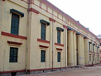 Calcutta Madrsah College established in 1780
 -
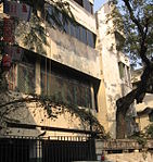 Muzaffar Ahmed Bhawan, CPI(M) party office at 31 Alimuddin Street
 -
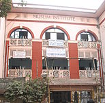 Muslim Institute


See also
- Taltola (Vidhan Sabha constituency)
References
- ^ "Taltala Police Station". Kolkata Police. Archived from the original on 8 June 2007. Retrieved 16 January 2008.
- ^ ISBN 978-0-19-563696-3.
- ^ Cotton, H.E.A., Calcutta Old and New, 1909/1980, p. 220, General Printers and Publishers Pvt. Ltd.
- ^ Cotton, H.E.A, p 72
- ^ Nair, P.Thankappan, The Growth and Development of Old Calcutta, in Calcutta, the Living City, Vol. I, pp. 18-19, Edited by Sukanta Chaudhuri, Oxford University Press, 1995 edition.
- ^ Detail Maps of 141 Wards of Kolkata, D.R.Publication and Sales Concern, 66 College Street, Kolkata – 700073
- ^ a b "Kolkata Police". Central Division. KP. Retrieved 9 March 2018.
- ^ "Know your ward".
- ^ "Provisional Population Totals, Table 4". Population, Decadal Growth Rate, Density and General Sex Ratio by Residence and Sex, West Bengal/ District/ Sub District, 1991 and 2001. Census Commission of India. Retrieved 10 October 2007.
- ^ Google maps