
Yerla River
You can help expand this article with text translated from the corresponding article in Cebuano. (April 2021) Click [show] for important translation instructions.
|
| Yerla River | |
|---|---|
| • coordinates | 17°52′47″N 74°16′2″E / 17.87972°N 74.26722°E |
| • elevation | 947 m (3,107 ft)[2] |
| Mouth | Krishna River |
• location | Bramhanal, Sangli, Maharashtra, India[3] |
• coordinates | 16°55′57″N 74°30′37″E / 16.93250°N 74.51028°E |
| Basin features | |
| Tributaries | |
| • left | Bhagyaganga River, Chand River[4][5] |
| • right | Nandani River |
The Yerla River, alternatively Yerala River, is a tributary of
Khatav taluka of Satara district. It flows along a valley flanked by the Vardhangad range to its right and the Mahimangad range to its left and its total length is about 125 km.[6] In Satara district, it passes through Mol, Lalgun, Pusegaon, Khatav, Vaduj and Nimsod. Later in Sangli district
it joins Krishna River near Brahmanal.
The Yerala is nonperennial river. This river is a major source of irrigation in the eastern part of Satara district and Sangli district in Maharashtra and helpful for seasonal agriculture production. The drainage network influences the economic and social development of people.[7]
Places and Temples
The first holy place on the river is Mhaskoba Temple, where the river originates. This temple is located near to village Mol in north of
Nagnathwadi near Lalgun. Later the river enters in Ner dam which is an attractive place for seasonal migratory birds.[8] In Pusegaon there is a famous temple of Shri Sevagiri Maharaj on the bank of Yerala river.[9] At Yeralwadi near Banpuri village the beautiful Yeralwadi dam is constructed on this river at the south of Vaduj. The region of Yeralwadi Dam is a birding hotspot in Satara district. Greater flamingoes, winter migratory ducks, waders have a great diversity in this region. Brahmanal in Sangli district has a beautiful confluence of river Yerala and river Krishna
.
Dams
- Near Ner village in Khatav taluka.
- At Yeralwadi near Banpuri village the Yeralwadi dam is constructed on this river at the south of Vaduj.
-
 Ner Dam on Yerla River, Satara
 -
 Yeralwadi Dam on Yerla River, Satara
 -
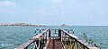
 Nandre Railway Bridge on Yerla River, Sangli
 -
 Yerla river next to Shri Nagnatha Temple,Nagnathwadi


References
- ^ "Yerla River source" (PDF). Water Resource Department, Govt. of Maharashtra. Retrieved 3 March 2023.
- ^ Yerla River. "Report on Aquifer Maps & Ground Water Management Plan, Khatav Taluka, Satara, Maharashtra (Part-I)" (PDF). Central Ground Water Board, Govt. of India. Retrieved 28 January 2023.
- ^ "Yerla River mouth/confluence" (PDF). Water Resource Department, Govt. of Maharashtra. Retrieved 3 March 2023.
- ^ "Chand River". Sakal Newspaper. Retrieved 23 April 2023.
- ^ "Identification of Groundwater Potential Zones in Khatav Tahsil using Geospatial Techniques" (PDF). International Journal of Applied Information Systems (IJAIS). 9-No.7. September 2015. Retrieved 23 April 2023.
- ^ "Yerla River length" (PDF). Water Resource Department, Govt. of Maharashtra. Retrieved 3 March 2023.
- ^ Yerla River. "District Survey Report 2020-2021 (Draft)". District Mining Officer Satara, Maharashtra. Retrieved 28 December 2022.
- ^ "Ner Dam". Sakal News Paper. Retrieved 6 February 2023.
- ^ "Shri Sevagiri Maharaj temple" (PDF). Govt. of Maharashtra. Retrieved 12 February 2023.