
1839 Ava earthquake
 | |
 1839 Ava earthquake (Southeast Asia) | |
| UTC time | 1839-03-23 24:30 |
|---|---|
| Local date | 23 March 1839 |
| Local time | 04:00 |
| Magnitude | 7.9–8.3 Mw |
| Epicenter | 21°54′N 96°00′E / 21.9°N 96.0°E |
| Fault | Sagaing Fault |
| Areas affected | Konbaung dynasty (present–day Myanmar) |
| Max. intensity | MMI XI (Extreme) |
| Foreshocks | Yes |
| Aftershocks | Yes |
| Casualties | 300–400 dead |
The 1839 Ava earthquake, also known as the Amarapura earthquake or Inwa earthquake, was a disastrous seismic event that struck present-day central Myanmar on March 23.
Tectonic setting
Myanmar is wedged between four tectonic plates; the Indian, Eurasian, Sunda and Burma plates that interact due to active geological processes. Along the west coast of the Coco Islands, off the Rahkine coast, and into Bangladesh, is a highly oblique convergent boundary known as the Sunda megathrust. This large fault marks the boundary between the Indian and Burma plates. The megathrust emerges from the seafloor in Bangladesh, where it runs parallel and east of the Chin Hills. This boundary continues to north of Burma where it ends at the eastern Himalayas.[3]
The
Earthquake
The Meiktila and Sagaing segment of the fault ruptured during this earthquake for a length of 400 km (250 mi), corresponding to a magnitude 8.1–8.3 earthquake, although little research has been conducted to provide further constrains.[5] On the basis for its overall lack of seismic activity, the Meiktila segment is believed to have ruptured during the earthquake. This segment runs from Nay Pyi Taw to Mandalay, a length of about 260 km (160 mi).[6][7] Remote sensing and field observation revealed a maximum displacement of 5–7 m (16–23 ft) along the trace of the 1839 rupture just outside Mandalay. This would place the magnitude at 7.4–8.0+ and generate a ~300 km (190 mi) rupture.[8][9]
Researchers at National Taiwan University combined lidar and macroseismic data from historic accounts to estimate its magnitude at ~Mw 7.9 and rupture length to be 285–325 km (177–202 mi). The 1839 earthquake ruptured two segments; the Meiktila segment in the south and Sagaing segment in the north. They estimated 5.5 m (18 ft) of displacement on the Sagaing segment while slip on the Meiktila segment was around 3.8 m (12 ft). The felt area based on the Modified Mercalli intensity was larger than the 1912 Maymyo earthquake (Mw 7.7) and similar in area to the 2002 Denali earthquake (Mw 7.9). The maximum assigned Modified Mercalli intensity was XI (Extreme).[10]
Damage and effects
The mainshock was preceded by a large foreshock in 1838 which also damaged the capital.[11] Great damage was reported in Inwa, so severe that the formal capital was moved to nearby Amarapura. In Mingun, a stupa sustained serious damage as a result of shaking. British officials in Myanmar recorded catastrophic damage and liquefaction in Mandalay and the surrounding area.[12][13] Many pagodas collapsed during the event. Chasms and fissures more than 10 ft (3.0 m) wide were seen in Amarapura and nearly every brick building was reduced to rubble. Some villages were swallowed up as a result of liquefaction.[13] By a contemporary British estimate, about 300–400 people died.[1] The shock also reversed the flow of the Irrawaddy River, where the currents became violent and overflowed its banks.[12] It was felt for thousands of miles away from the epicenter, as far as Dhaka, Kolkata and Bangkok.[2]
Gallery
-
 Large cracks in the incomplete Mingun Pahtodawgyi caused by the earthquake
 -
 Nan Myint Tower slightly tilted due to ground effects from the tremor
 -
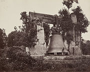 The Mingun Bell resting on the ground after losing its supports to the quake, pictured in 1873
 -
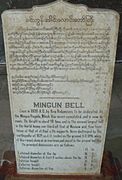 A plaque that stands beside the Mingun Bell
 -
 The Hsinbyume Pagoda in 2014. Extensive restoration was done by Mindon Min in 1874 after the earthquake.
 -
 The Maha Aungmye Bonzan Monastery after repair works
 -
 Preserved ruins from the ancient capital
 -
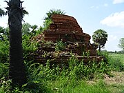 Overgrown ruins of a stupa
.jpg)


,_Mandalay_20.jpg)
_Myanmar(Burma).jpg)

See also
References
- ^ a b Oldham, Thomas. "A Catalogue of Indian Earthquakes from the earliest time to the end of AD 1869". Memoirs of the Geological Survey of India. XIX.
- ^ doi:10.7289/V5TD9V7K.
- ^ .
- S2CID 134291037. Retrieved 23 March 2021.
- ^ hdl:10220/19774.
- ^ Tapponnier, Paul; Kerry, Kerry (21 January 2010). "The Catastrophe in Haiti: A Repeat Lesson for Us all" (PDF). RSIS Commentaries. Nanyang Technological University. Retrieved 23 March 2021.
- ^ Thant, Htoo (7 August 2019). "Govt unveils quake preparedness plan". Myanmar Times. Myanmar Times. Archived from the original on 24 June 2021. Retrieved 23 March 2021.
- Bibcode:2014AGUFM.T24B..04W. Retrieved 23 March 2021.
- ^ Xinhua (25 November 2009). "Myanmar setting up global positioning system for earthquake monitoring". People's Daily Online. People's Daily Online. Archived from the original on 22 March 2016. Retrieved 23 March 2021.
- .
- ^ "Significant Earthquake Information MYANMAR (BURMA): AVA (INNWA)". NGDC NCEI. Retrieved 23 March 2021.
- ^ a b "Some Documents of Tharrawaddy's Reign: 1837–1846, Part I". SOAS Bulletin of Burma Research. 1. 2003.
- ^ a b "Burmah". The Asiatic Journal. XXX. 1839.