
Anangpur Dam
| Anangpur Dam | |
|---|---|
 Anangpur Dam | |
| Location | Delhi and Haryana |
| Coordinates | 28°27′45″N 77°15′52″E / 28.46250°N 77.26444°E |
| Construction began | 8th century |
| Dam and spillways | |
| Impounds | local nullah (stream) |
| Height | 7 m (23 ft) |
| Length | 50 m (164 ft) |
| Reservoir | |
| Creates | Water supply & Irrigation |
The Anangpur Dam is an Indian hydraulic engineering structure built during the reign of the King Anangpal I of the Tomara dynasty in the 8th century. It is located near the Anangpur village in Faridabad district, Haryana, India.[1]
History
The king Anangpal Tomar I declared himself an independent ruler and established the Tomar Dynasty of Delhi in the early 8th century. He built his capital at the Anangpur village in Haryana and expanded his kingdom from there. He is said to have built numerous palaces and temples during his reign, majority of which are now completely diminished.[2] Anangpal I is often misunderstood to be Anangpal II.[3][4]
Structure

-
 Downstream view of the dam
 -
 Gallery entry into the dam
 -
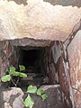 Steps into the gallery inside the dam
 -
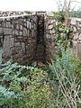 Sluice inlet in the dam


.jpg)
The ancient and solid
Topography
A local nala (stream) originating in the
It is an important biodiversity area within the Northern Aravalli leopard wildlife corridor stretching from Sariska Tiger Reserve to Delhi. Historical place around sanctuary are Badkhal Lake (6km northeast), 10th century ancient Surajkund reservoir, Damdama Lake, Tughlaqabad Fort and Adilabad ruins (both in Delhi), Chhatarpur Temple (in Delhi).[8] It is contiguous to the seasonal waterfalls in Pali-Dhauj-Kot villages of Faridabad, the scared Mangar Bani and the Asola Bhatti Wildlife Sanctuary.[9]
Access
It is approachable by road from
See also
References
- ^ Tomars of Delhi by Harihar Niwas Dwivedi. Gwalior: Vidya Mandir Publication. 1983. p. 188.
- ISBN 978-81-87358-29-9.
- ^ Tomars of Delhi by Harihar Niwas Dwivedi. Gwalior: Vidya Mandir Publication. 1983. p. 188.
- ^ Tomars of Delhi by Harihar Niwas Dwivedi. Gwalior: Vidyamandir Publications. 1983. pp. 238–239.
- ^ ISBN 81-7436-354-8. Retrieved 5 September 2009.)
One of the two significant structures in the area, the dam lies about 1 km [0.62 mi] to the north of the Anangpur village. A path from the main village street will lead you in to flat pastureland. Head for the small rocky hill ahead of you and climb over it. On the other side is another flat area, rather thickly covered in thorn trees. It is worth finding a way through them to the dam that straddles the gap between the two nearby hills. The dam is an impressive edifice 50 m [160 ft] wide and 7 m [23 ft] high built from accurately hewn quartzite blocks.---There is a passage for the egress of water at the level of the ground on the dammed side. The flat land across which you have walked is clearly caused by centuries of silt deposits in the lake that once existed behind this dam. The land around has been vwey heavily quarried recently, so further archaeological finds are unlikely.
{{cite book}}:|work=ignored (help - ^ "Paani Yatra Challenge of the Balance" (PDF). Hauz-i-Shamsi. Centre for Science and Environment: Orientation programme for Oslo University students. 31 December 2002. p. 31. Archived from the original (PDF) on 17 November 2008.
- ^ )
- ^ ASOLA BHATTI WILD LIFE SANCTUARY Archived 16 August 2011 at the Wayback Machine, Department of Forest, Delhi Government
- ^ पाली गांव की पहाड़ियों पर डैम बनाकर रोका जाएगा झरनों का पानी