
Bình Minh
You can help expand this article with text translated from the corresponding article in Vietnamese. (March 2009) Click [show] for important translation instructions.
|
Bình Minh
Thị xã Bình Minh | |
|---|---|
UTC+7 (UTC + 7) |
Bình Minh is a town of
The area of Bình Minh is 93.62 km2 with 95,282 inhabitants, 2013 census.
As of 2003 the district had a population of 177,275.[1] The district covers an area of 244 km2. The district capital lies at Cái Vồn.[1]
Geography
Bình Minh town lies to the south-west of Vĩnh Long province. It shares the border with: Bình Tân district to the North. Trà Ôn district and Cần Thơ City to the South. Bình Tân district and Cần Thơ City to the West. Tam Bình district to the East
The land of pomelos - a plan in the future
Binh Minh is famous for
Commune-level subdivisions
The town of Binh Minh consists of three wards and five communes.
The three new wards comprise former Cai Von town and some lands from
Wards:
Communes:
- Thuận An
- Mỹ Hòa
- Đông Bình
- Đông Thạnh
- Đông Thành
History of the town
Bình Minh was formerly a district of Vĩnh Long under the control of Republic of Vietnam. Its headquarters was located in Mỹ Thuận commune. During the
According to the decree 59/CP on 3 March 1977, the government decided to merge Bình Minh and Tam Bình into a new district named Tam Bình. In fact, Bình Minh and Tam Bình was two independent ones without any changes.
On 29 September 1981, Ministerial Council re-established Bình Minh district from the former part. Bình Minh comprised Cái Vồn town and 6 communes such as: Tân Quới, Tân Lược, Thành Lợi, Mỹ Thuận, Mỹ Hòa, Đông Thành.
Under the decree no 86-HĐBT dated 27 March 1985, Mỹ Thuận commune was split into 3 new communes: Mỹ Thuận commune, Nguyễn Văn Thảnh commune and Thuận An commune under control of Bình Minh district, Cửu Long province.
Since 1991, Bình Minh district has been one of 6 districts of the newly reestablished province, Vĩnh Long.
On 9 August 1994, government issued the decree no 85/CP to split Đông Thành commune into Đông Thành, Đông Bình and Đông Thạnh commune; Thành Lợi commune into Thành Lợi, Thành Đông and Thành Trung commune; Tân Quới commune into Tân Quới, Tân Bình, Tân Thành commune; Tân Lược into Tân Quới, Tân An Thạnh, Tân Hưng commune.
On 31 July 2007, government split the district into 2 districts named respectively Bình Minh and Bình Tân (New Bình Minh).
Bình Minh comprised Cái Vồn town and 5 communes: Thuận An, Mỹ Hòa, Đông Bình, Đông Thành, Đông Thạnh. Bình Tân comprised 11 communes: Mỹ Thuận, Nguyễn Văn Thảnh, Thành Lợi, Thành Đông, Thành Trung, Tân Quới, Tân Thành, Tân Bình, Tân Lược, Tân An Thạnh and Tân Hưng.
On 17 September 2010, Ministry of Construction upgraded Cái Vồn town into the fourth-level town.
On 28 December 2012, Government upgraded Bình Minh district into Bình Minh town with 3 wards and 5 communes.
Historical monuments
- Mỹ Thuận temple
- Long An pagoda
- Đông Phước old pagoda
- Bà pagoda (Chinese community)
- Bửu Hưng pagoda
Gallery
-
 Riverfront house in the center of Bình Minh town
 -
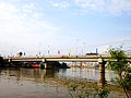 Cái Vồn Nhỏ Bridge connects Cái Vồn ward and Đông Thuận ward in Bình Minh town.


References
- ^ a b "Districts of Vietnam". Statoids. Retrieved March 13, 2009.
- ISBN 978-1-61251-433-8.
10°07′59″N 105°49′59″E / 10.133°N 105.833°E
Districts of the Mekong Delta | ||
|---|---|---|
| Cần Thơ city |  | |
| An Giang province |
| |
| Bạc Liêu province | ||
| Bến Tre province | ||
| Cà Mau province | ||
| Đồng Tháp province | ||
| Hậu Giang province |
| |
| Kiên Giang province | ||
| Long An province | ||
| Sóc Trăng province | ||
| Tiền Giang province |
| |
| Trà Vinh province | ||
| Vĩnh Long province | ||
※ denotes provincial seat. | ||