
Lạng Sơn
21°50′52″N 106°45′28″E / 21.84778°N 106.75778°E
You can help expand this article with text translated from the corresponding article in Vietnamese. (October 2023) Click [show] for important translation instructions.
|
Lạng Sơn
Thành phố Lạng Sơn | |
|---|---|
| Lạng Sơn City | |
 A corner of Lạng Sơn city | |
|
Sán Chỉ... | |
| Climate | Cfa |
| Website | thanhpho |
Lạng Sơn (
History
Due to its geography as Vietnam's gateway to China (being located just across from
After the end of the
Geology and climate

The surface rocks in the area are a
.jpg)
Under the Köppen climate classification, Lạng Sơn has a humid subtropical climate (Cfa). It had been snowed in the city on 24 January 2016.[5]
| Climate data for Lạng Sơn | |||||||||||||
|---|---|---|---|---|---|---|---|---|---|---|---|---|---|
| Month | Jan | Feb | Mar | Apr | May | Jun | Jul | Aug | Sep | Oct | Nov | Dec | Year |
| Record high °C (°F) | 31.6 (88.9) |
36.4 (97.5) |
36.7 (98.1) |
38.6 (101.5) |
39.8 (103.6) |
38.8 (101.8) |
37.6 (99.7) |
37.7 (99.9) |
36.6 (97.9) |
35.2 (95.4) |
33.0 (91.4) |
32.2 (90.0) |
39.8 (103.6) |
| Mean daily maximum °C (°F) | 17.5 (63.5) |
18.8 (65.8) |
21.9 (71.4) |
26.5 (79.7) |
30.2 (86.4) |
31.5 (88.7) |
31.7 (89.1) |
31.3 (88.3) |
30.2 (86.4) |
27.5 (81.5) |
23.7 (74.7) |
19.8 (67.6) |
25.9 (78.6) |
| Daily mean °C (°F) | 13.1 (55.6) |
14.7 (58.5) |
18.0 (64.4) |
22.3 (72.1) |
25.5 (77.9) |
26.9 (80.4) |
27.1 (80.8) |
26.6 (79.9) |
25.2 (77.4) |
22.3 (72.1) |
18.4 (65.1) |
14.6 (58.3) |
21.3 (70.3) |
| Mean daily minimum °C (°F) | 10.1 (50.2) |
12.0 (53.6) |
15.4 (59.7) |
19.3 (66.7) |
22.1 (71.8) |
23.8 (74.8) |
24.0 (75.2) |
23.7 (74.7) |
22.2 (72.0) |
18.8 (65.8) |
14.8 (58.6) |
11.0 (51.8) |
18.1 (64.6) |
| Record low °C (°F) | −2.1 (28.2) |
−1.7 (28.9) |
0.9 (33.6) |
6.2 (43.2) |
11.1 (52.0) |
15.1 (59.2) |
18.6 (65.5) |
17.0 (62.6) |
13.2 (55.8) |
5.5 (41.9) |
1.7 (35.1) |
−1.5 (29.3) |
−2.1 (28.2) |
| Average rainfall mm (inches) | 35.4 (1.39) |
33.3 (1.31) |
50.3 (1.98) |
91.1 (3.59) |
159.4 (6.28) |
191.3 (7.53) |
236.0 (9.29) |
227.6 (8.96) |
141.8 (5.58) |
78.9 (3.11) |
41.4 (1.63) |
24.2 (0.95) |
1,318.2 (51.90) |
| Average rainy days | 9.3 | 10.0 | 13.2 | 12.5 | 13.5 | 15.6 | 16.6 | 17.2 | 12.4 | 8.6 | 6.5 | 5.9 | 141.3 |
| Average relative humidity (%)
|
80.4 | 82.5 | 83.6 | 82.7 | 81.6 | 83.6 | 84.2 | 85.9 | 84.7 | 82.0 | 80.0 | 78.0 | 82.5 |
| Mean monthly sunshine hours | 74.5 | 59.2 | 59.2 | 98.1 | 171.2 | 161.4 | 180.2 | 171.3 | 174.4 | 157.5 | 136.3 | 115.5 | 1,561.4 |
| Source 1: Vietnam Institute for Building Science and Technology[6] | |||||||||||||
| Source 2: The Yearbook of Indochina (1932-1933)[7] | |||||||||||||
Topography and geology
The city has diverse topographical and geological features, including hill, mountainous, half mountainous, coastal plains and coastal sand dunes.
The hilly region is in the west, stretching from north to south (in parts of communes: Dong Son, Thuan Duc) with an average elevation of 12–15 m, with total area of 64.93 km2, 41.7% of the city total area. Residents here live on agriculture, forestry, farming. The soil in this area is poor in nutrition, infertile and subject to continuous erosion due to its slope of 7-10%.
The half hilly region surrounds a plain with an average elevation of 10 m from north-east - north to north-west – south-west and south – south-east.[clarification needed] This region covers commues and wards of Bắc Lý, Nam Lý, Nghĩa Ninh, Bắc Nghĩa, Đức Ninh, Đức Ninh Đông, Lộc Ninh and Phú Hải with total area of 62.87 km2, or accounts for 40.2% of the city total area. Residents here lives on industrial, handcraft, trading and a small percentage lives on farming. This region is not very fertile, subject to alum. However, thanks to the heavy distribution of rivers and lakes, ponds and pools, it's better for agriculture than the hilly region. The plain with the average of 2.1 m, with little slope, accounting for 0.2% of the city area (5.76 km2). Most of the city's commercial, administrative and main streets concentrate in this narrow regions. Coastal sand dune area is on the east of the city, with an area of 21.98 km2, making up 14,3% of the total area.[citation needed]
Gallery
-
 Đông Kinh market of Lạng Sơn city.
 -
 Kỳ Lừa Bridge spans across Kỳ Cùng River
 -
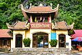
![Kỳ Cùng Temple (also known as Quan Lớn Tuần Tranh Temple) [8]](//upload.wikimedia.org/wikipedia/commons/thumb/0/05/%C4%90%E1%BB%81n_K%E1%BB%B3_C%C3%B9ng.jpg/120px-%C4%90%E1%BB%81n_K%E1%BB%B3_C%C3%B9ng.jpg) Kỳ Cùng Temple (also known as Quan Lớn Tuần Tranh Temple) [8]
Kỳ Cùng Temple (also known as Quan Lớn Tuần Tranh Temple) [8] -
![Kỳ Cùng stone wharf[9] belongs to Lạng Sơn city. In 1993, the temple was recognized as a national monument.](//upload.wikimedia.org/wikipedia/commons/thumb/b/bd/B%E1%BA%BFn_%C4%91%C3%A1_K%E1%BB%B3_C%C3%B9ng.jpg/120px-B%E1%BA%BFn_%C4%91%C3%A1_K%E1%BB%B3_C%C3%B9ng.jpg) Kỳ Cùng stone wharf[9] belongs to Lạng Sơn city. In 1993, the temple was recognized as a national monument.
Kỳ Cùng stone wharf[9] belongs to Lạng Sơn city. In 1993, the temple was recognized as a national monument. -
-
 Hilly area.
 -
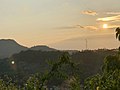 Lạng Sơn hills and mountains viewed from Mạc citadel.


![Kỳ Cùng Temple (also known as Quan Lớn Tuần Tranh Temple) [8]](/File:%C4%90%E1%BB%81n_K%E1%BB%B3_C%C3%B9ng.jpg)
![Kỳ Cùng stone wharf[9] belongs to Lạng Sơn city. In 1993, the temple was recognized as a national monument.](/File:B%E1%BA%BFn_%C4%91%C3%A1_K%E1%BB%B3_C%C3%B9ng.jpg)


See also
References
- ISBN 978-0-521-24931-7. original titles Les débuts de la Troisième République 1871-1898 by Jean-Marie Mayeur and La République radicale? 1898-1914 by Madeleine Rebérioux.
- ^ Hy V. Luong - Tradition, Revolution, and Market Economy in a North Vietnamese ... 2010- Page 37 "In March 1885, as Chinese troops from Kwangsi defeated a French force of 35,000 in Lạng-Sơn, Black Flag troops ..."
- ISSN 0190-8286. Retrieved 2023-03-18.
- ^ Journal of Geology - Issues 15-20 2000 - Page 8 "Lang Sơn Formation of Induan age, lying unconformably upon Upper Permian limestone in the vicinities of Lạng Sơn Town, Bản Thí, Đông Mỏ, Chợ Bãi and Hữu Lũng, includes medium-grained sandstone rhythmically interbedded with .."
- ^ Tuyết xuống tới thành phố Lạng Sơn Dường như tuyết đang tấn công toàn bộ khu vực vùng núi phía bắc khi mà không chỉ trên các điểm cao, vùng thấp như... | By VTV24 | Facebook, retrieved 2024-02-23
- ^ "Vietnam Institute for Building Science and Technology" (PDF).
- ^ The Yearbook of Indochina (1932–1933)
- ^ Kỳ Cùng Temple is located on the left bank of Kỳ Cùng River and right at the beginning of Kỳ Cùng Bridge, in Lạng Sơn city. In 1993, the temple was recognized as a national monument.
- ^ Kỳ Cùng stone wharf is located on the right bank of Kỳ Cùng river, near Kỳ Cùng Bridge and opposite Kỳ Cùng temple. Around in 1778, the temple was listed by Governor Ngô Thì Sĩ as one of the eight beautiful landscapes of Lạng Sơn Town) (Bát Cảnh Town). In 1993, Kỳ Cùng Stone Wharf was recognized as a national monument.
| Bắc Giang province |  | |
|---|---|---|
| Bắc Kạn province | ||
| Cao Bằng province | ||
| Hà Giang province | ||
| Lạng Sơn province | ||
| Phú Thọ province | ||
| Quảng Ninh province |
| |
| Thái Nguyên province | ||
| Tuyên Quang province | ||
※ denotes provincial seat. | ||
| International | |
|---|---|
| National | |
| Geographic | |
| Other | |