
Caribbean Sea


The Caribbean Sea[1] is a sea of the Atlantic Ocean in the tropics of the Western Hemisphere. It is bounded by Mexico and Central America to the west and southwest, to the north by the Greater Antilles starting with Cuba, to the east by the Lesser Antilles, and to the south by the northern coast of South America. The Gulf of Mexico lies to the northwest. The entire Caribbean Sea area, the numerous islands of the West Indies, and adjacent mainland coastal regions are collectively known as the Caribbean.
The Caribbean Sea is one of the largest seas on Earth and has an area of about 2,754,000 km2 (1,063,000 sq mi).[2][3] The sea's deepest point is the Cayman Trough, between the Cayman Islands and Jamaica, at 7,686 m (25,217 ft) below sea level. The Caribbean coastline has many gulfs and bays: the Gulf of Gonâve, the Gulf of Venezuela, the Gulf of Darién, Golfo de los Mosquitos, the Gulf of Paria and the Gulf of Honduras.
The Caribbean Sea has the world's second-largest
History

The name Caribbean derives from the
From the 16th century,

The Caribbean Sea had been unknown to the populations of Eurasia until 1492 when Christopher Columbus sailed into Caribbean waters on a quest to find a sea route to Asia. At that time the Americas were generally unknown to most Europeans, although they had been visited in the 10th century by the Vikings. Following Columbus's discovery of the islands, the area was quickly colonized by several Western cultures (initially Spain, then later England, the Dutch Republic, France, Courland and Denmark). Following the colonization of the Caribbean islands, the Caribbean Sea became a busy area for European-based marine trading and transports, and this commerce eventually attracted pirates such as Samuel Bellamy and Blackbeard.
As of 2015[update] the area is home to 22 island
Extent
The International Hydrographic Organization defines the limits of the Caribbean Sea as follows:[6]
- On the North. In the Windward Channel – a line joining Caleta Point (74°15′W) in Cuba and Pearl Point (19°40′N) in Haiti. In the Mona Passage – a line joining Cape Engaño and the extreme of Agujereada (18°31′N 67°08′W / 18.517°N 67.133°W) in Puerto Rico.

- Eastern limits. From Point San Diego (Puerto Rico) Northward along the meridian thereof (65°39′W) to the 100-fathom line, thence Eastward and Southward, in such a manner that all islands, shoals and narrow waters of the Lesser Antilles are included in the Caribbean Sea as far as Galera Point (Northeast extremity of the island of Trinidad). From Galera Point through Trinidad to Galeota Point (Southeast extreme) and thence to Baja Point (9°32′N 61°0′W / 9.533°N 61.000°W) in Venezuela.
Although Barbados is an island on the same continental shelf, it is considered to be in the Atlantic Ocean rather than the Caribbean Sea.[7]
Geology
The Caribbean Sea is an oceanic sea on the

The geological age of the Caribbean Sea is estimated to be between 160 and 180 million years and was formed by a horizontal fracture that split the
The Caribbean's floor is composed of sub-oceanic

The Caribbean seafloor is divided into five basins separated from each other by underwater ridges and mountain ranges. Atlantic Ocean water enters the Caribbean through the Anegada Passage between the Lesser Antilles and the Virgin Islands and the Windward Passage between Cuba and Haiti. The Yucatán Channel between Mexico and Cuba links the Gulf of Mexico with the Caribbean. The deepest points of the sea lie in Cayman Trough with depths reaching approximately 7,686 m (25,220 ft). Despite this, the Caribbean Sea is considered a relatively shallow sea compared to other bodies of water. The pressure of the South American Plate to the east of the Caribbean causes the region of the Lesser Antilles to have high volcanic activity. A very serious eruption of Mount Pelée in 1902 caused many casualties.
The Caribbean sea floor is also home to two
- List of islands in the Caribbean
Oceanography

The
The Caribbean's depth in its wider basins and deep-water temperatures are similar to those of the Atlantic. Atlantic deep water is thought to spill into the Caribbean and contribute to the general deep water of its sea.[12] The surface water (30 m; 100 ft) acts as an extension of the northern Atlantic as the Guiana Current and part of the North Equatorial Current enter the sea on the east. On the western side of the sea, the trade winds influence a northerly current which causes an upwelling and a rich fishery near Yucatán.[13]
Ecology
The Caribbean is home to about 9% of the world's
Since 2005 unusually warm Caribbean waters have been increasingly threatening Caribbean coral reefs. Coral reefs support some of the most diverse marine habitats in the world, but they are fragile ecosystems. When tropical waters become unusually warm for extended periods of time, microscopic plants called zooxanthellae, which are symbiotic partners living within the coral polyp tissues, die off. These plants provide food for the corals and give them their color. The result of the death and dispersal of these tiny plants is called coral bleaching, and can lead to the devastation of large areas of reef. Over 42% of corals are completely bleached, and 95% are experiencing some type of whitening.[15] Historically the Caribbean is thought to contain 14% of the world's coral reefs.[16]

The habitats supported by the reefs are critical to such tourist activities as
In connection with the foregoing, the Institute of Marine Sciences and Limnology of the National Autonomous University of Mexico, conducted a regional study, funded by the Department of Technical Cooperation of the International Atomic Energy Agency, in which specialists from 11 Latin American countries (Colombia, Costa Rica, Cuba, Guatemala, Haiti, Honduras, Mexico, Nicaragua, Panama, Dominican Republic, Venezuela) plus Jamaica participated. The findings indicate that heavy metals such as mercury, arsenic, and lead, have been identified in the coastal zone of the Caribbean Sea. Analysis of toxic metals and hydrocarbons is based on the investigation of coastal sediments that have accumulated less than 50 meters deep during the last hundred and fifty years. The project results were presented in Vienna in the forum "Water Matters", and the 2011 General Conference of said multilateral organization.[20]
After the Mediterranean, the Caribbean Sea is the second most polluted sea. Pollution (in the form of up to 300,000 tonnes of solid garbage dumped into the Caribbean Sea each year) is progressively endangering marine ecosystems, wiping out species, and harming the livelihoods of the local people, which is primarily reliant on tourism and fishing.[21][22][23][24]
KfW took part in a €25.7 million funding agreement to eliminate marine trash and boost the circular economy in the Caribbean's Small Island Developing States. The project "Sustainable finance methods for marine preservation in the Caribbean" will assist remove solid waste and keep it out of the marine and coastal environment by establishing a new facility under the Caribbean Biodiversity Fund (CBF).[21] Non-governmental organizations, universities, public institutions, civil society organizations, and the corporate sector are all eligible for financing. The project is estimated to prevent and remove at least 15 000 tonnes of marine trash, benefiting at least 20 000 individuals.[21]
Climate

The climate of the Caribbean is driven by the low latitude and tropical ocean currents that run through it. The principal ocean current is the
Rainfall varies with elevation, size, and water currents (cool upwelling keep the
Flora and fauna
The region has a high level of
Vegetation
The vegetation of the region is mostly
In shallow water
Fauna
Marine
There are 90 species of
There are 500 species of
All 170 species of
In the Caribbean, 600 species of birds have been recorded, of which 163 are
Economy and human activity

The Caribbean region has seen a significant increase in human activity since the colonization period. The sea is one of the largest oil production areas in the world, producing approximately 170 million tons[clarification needed] per year.[33] The area also generates a large fishing industry for the surrounding countries, accounting for 500,000 tonnes (490,000 long tons; 550,000 short tons) of fish a year.[34]
Human activity in the area also accounts for a significant amount of pollution. The Pan American Health Organization estimated in 1993 that only about 10% of the sewage from the Central American and Caribbean Island countries is properly treated before being released into the sea.[33]
The Caribbean region supports a large
Gallery
-
 Sunrise over the south beach of Jamaica
 -

-
 Marie Galante, Guadeloupe
 -
 Beach of Curaçao
 -
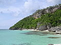 Mona Island, Puerto Rico
 -
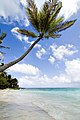
 Palm Beach, Aruba
 -
 Cayo Coco, Cuba
 -

-
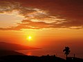
 Sunset in the Caribbean Sea
 -


.jpg)
.jpeg)

.jpg)
.jpeg)


See also
- American Mediterranean Sea
- Greater Antilles
- Hispanic America
- Ibero-America
- Intra-Americas Sea
- Kick 'em Jenny
- Latin America
- Lesser Antilles
- List of Caribbean Countries
- List of Caribbean countries by population
- Piracy in the Caribbean
- Territorial evolution of the Caribbean
- West Indies
References
- Papiamento: Laman Karibe)
- ^ The Caribbean Sea Archived 2018-01-04 at the Wayback Machine All The Sea. URL last accessed May 7, 2006
- ^ "The Caribbean Sea". Archived from the original on 2018-04-21. Retrieved 2018-02-07.
- ^ "Mesoamerican Reef | Places | WWF". World Wildlife Fund. Archived from the original on 2020-11-13. Retrieved 2016-10-21.
- ^
ISSN 0002-9955.
The Pacific Ocean, south of this isthmus [Panama], was known to the early explorers as the South Sea, and the Caribbean, lying to the north, as the North Sea.
- ^ "Limits of Oceans and Seas, 3rd edition" (PDF). International Hydrographic Organization. 1953. Archived from the original (PDF) on 8 October 2011. Retrieved 28 December 2020.
- ^ Stefanov, William (16 December 2009). "Greater Bridgetown Area, Barbados". NASA Earth Observatory. Archived from the original on 28 October 2020. Retrieved 16 September 2020.
- ^ National Geophysical Data Center, 1999. Global Land One-kilometer Base Elevation (GLOBE) v.1. Hastings, D. and P.K. Dunbar. National Geophysical Data Center, NOAA Archived 2011-02-10 at the Wayback Machine. doi:10.7289/V52R3PMS [access date: 2015-03-16]
- ^ Amante, C. and B.W. Eakins, 2009. ETOPO1 1 Arc-Minute Global Relief Model: Procedures, Data Sources and Analysis. NOAA Technical Memorandum NESDIS NGDC-24. National Geophysical Data Center, NOAA Archived 2015-06-26 at the Wayback Machine. doi:10.7289/V5C8276M [access date: 2015-03-18].
- ^ Iturralde-Vinent, Manuel (2004), The first inhabitants of the Caribbean, Cuban Science Network. URL accessed on 28/07/2007
- ^ Dawicki, Shelley. "Tsunamis in the Caribbean? It's possible". Oceanus. Archived from the original on November 16, 2011. Retrieved April 30, 2006.
- ISBN 978-1-55297-942-6.
- ISBN 978-1-55297-942-6.
- ^ Status of coral reefs in the Caribbean and Atlantic Ocean Archived June 21, 2006, at the Wayback Machine World Resource Institute. URL accessed on April 29, 2006.
- ^ [1] Archived 2014-11-29 at the Wayback Machine Inter Press Service News Agency – Mesoamerican Coral Reef on the way to becoming a Marine Desert
- ISBN 978-0-679-40830-7.
- ^ Alarm sounded for Caribbean coral Archived 2011-08-12 at the Wayback Machine. BBC News. URL accessed on April 29, 2006.
- ^ Protocol Concerning Specially Protected Areas and Wildlife to the Convention for the Protection and Development of the Marine Environment of the Wider Caribbean Region (SPAW) Archived 2018-04-05 at the Wayback Machine NOAA Fisheries: Office of Protected Resources. URL accessed on April 30, 2006.
- ^ Caribbean Conservation Corporation Archived October 1, 2006, at the Wayback Machine Orion Online. URL last accessed May 1, 2006.
- ^ Analysis of Contaminants in the Caribbean Sea over the last 150 years Archived 2017-05-17 at the Wayback Machine. National Autonomous University of Mexico (UNAM) 2012 (Spa).
- ^ a b c "The Clean Oceans Initiative". European Investment Bank. 2023-02-23. Archived from the original on 2023-02-23. Retrieved 2023-02-23.
- ^ "Pollution in the Mediterranean | UNEPMAP". www.unep.org. Archived from the original on 2023-02-23. Retrieved 2023-02-23.
- ^ "Over 200,000 tonnes of plastic leaking into the Mediterranean each year – IUCN report". IUCN. 2020-10-27. Archived from the original on 2023-02-23. Retrieved 2023-02-23.
- ^ "Marine Pollution Threatens the Caribbean Sea". World Bank. Archived from the original on 2023-02-23. Retrieved 2023-02-23.
- ^ "NASA – NASA Satellites Record a Month for the Hurricane History Books". www.nasa.gov. Archived from the original on 2011-09-18. Retrieved 2006-12-09.
- ISBN 978-0-7613-3223-7
- ^ Caribbean seagrass. Seagrass watch, retrieved April 23, 2009.
- ^ Robert James Menzies, John C Ogden. "Caribbean Sea" Archived 2011-08-04 at the Wayback Machine. Britannica Online Encyclopaedia.
- ^ Severin Carrell, "Caribbean Sea Turtles Close to Extinction", The Independent, 28 November 2004.
- ^ Historic Caribbean Sea Turtle Population falls 99%. Plunge has significant ecological consequences. Mongabay.com (August 1, 2006).
- ^ Conservation International Caribbean Islands Archived 2013-05-22 at the Wayback Machine, Threatened Species.
- ^ "Birdlife International" Archived 2020-12-19 at the Wayback Machine – Red List Cuba.
- ^ a b An Overview of Land Based Sources of Marine Pollution Archived 2006-12-07 at the Wayback Machine Caribbean Environment Programme. URL last accessed May 14, 2006.
- ^ LME 12: Caribbean Sea Archived 2006-05-04 at the Wayback Machine NOAA Fisheries Northeast Fisheries Science Center Narragansett Laboratory. URL last accessed May 14, 2006.
- ^ Reefs at Risk in the Caribbean: Economic Valuation Methodology Archived 2012-02-27 at the Wayback Machine World Resources Institute 2009.
Further reading
- Donovan, Stephen K., and Trevor A. Jackson, eds. Caribbean Geology: An Introduction (1994) online
- Gallegos, Artemio. "Descriptive physical oceanography of the Caribbean Sea." Small Islands Marine Science and Sustainable Development 51 (1996): 36–55.
- Glover K., Linda (2004), Defying Ocean's End: An Agenda For Action, Island Press, p. 9. ISBN 978-1-55963-753-4
- Morgan, Philip D. et al. Sea and Land: An Environmental History of the Caribbean (Oxford University Press, 2022) online review
- Snyderman, Marty (1996), Guide to Marine Life: Caribbean-Bahamas-Florida, Aqua Quest Publications, pp. 13–14, 19. ISBN 978-1-881652-06-9
- Wood, Robert E. "Caribbean cruise tourism: Globalization at sea." Annals of tourism research 27.2 (2000): 345–370.
- Woodring, Wendell Phillips. "Caribbean land and sea through the ages." Geological Society of America Bulletin 65.8 (1954): 719–732. GSA Bulletin (1954) 65 (8): 719–732. doi.org/10.1130/0016-7606(1954)65[719:CLASTT]2.0.CO;
- Peters, Philip Dickenson (2003), Caribbean WOW 2.0, Islandguru Media, p. 100^^75;4. ISBN 978-1-929970-04-9
- Reefs at Risk in the Caribbean: Economic Valuation Methodology, World Resources Institute 2007.