
Hispaniola
La Española ( Taino) | |
|---|---|
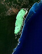
 View from the ISS, 2011 | |
.svg) | |
| Geography | |
| Location | Caribbean Sea |
| Coordinates | 19°N 71°W / 19°N 71°W |
| Archipelago | Greater Antilles |
| Major islands | Gonâve Alto Velo |
| Area | 76,192 km2 (29,418 sq mi) |
| Area rank | 22nd |
| Coastline | 3,059 km (1900.8 mi) |
| Highest elevation | 3,175 m (10417 ft)[1] |
| Highest point | Pico Duarte |
| Administration | |
| Capital and largest city | Santo Domingo (pop. 2,201,941) |
| Area covered | 48,445 km2 (18,705 sq mi; 63.6%) |
| Capital and largest city | Port-au-Prince (pop. 1,234,742) |
| Area covered | 27,747 km2 (10,713 sq mi; 36.4%) |
| Demographics | |
| Population | 22,278,000[2] (2020) (both countries combined) |
| Pop. density | 280.8/km2 (727.3/sq mi) |
Hispaniola (/ˌhɪspənˈjoʊlə/,[3][4][5] also UK: /-pænˈ-/)[6][7][8][9] is an island in the Caribbean that is part of the Greater Antilles. Hispaniola is the most populous island in the West Indies, and the region's second largest in area, after the island of Cuba. The 76,192-square-kilometre (29,418 sq mi) island is divided into two separate nations: the Spanish-speaking Dominican Republic (48,445 km2 (18,705 sq mi) to the east and the French/Haitian Creole-speaking Haiti (27,750 km2 (10,710 sq mi) to the west. The only other divided island in the Caribbean is Saint Martin, which is shared between France (Saint Martin) and the Netherlands (Sint Maarten).
Hispaniola is the site of one of the first European forts in the Americas, La Navidad (1492–1493), as well as the first settlement and proper town, La Isabela (1493–1500), and the first permanent settlement, the current capital of the Dominican Republic, Santo Domingo (est. 1498). These settlements were founded successively during each of Christopher Columbus's first three voyages.[10][11][12][13]
The
Etymology
The island was called by various names by its native people, the
When Columbus took possession of the island in 1492, he named it Insula Hispana in Latin[16] and La Isla Española in Spanish,[17] both meaning "the Spanish island". Las Casas shortened the name to Española, and when Peter Martyr detailed his account of the island in Latin, he rendered its name as Hispaniola.[17]
Due to Taíno, Spanish and French influences on the island, historically the whole island was often referred to as Haïti, Hayti, Santo Domingo, or Saint-Domingue.[18] Martyr's literary work was translated into English and French soon after being written, the name Hispaniola became the most frequently used term in English-speaking countries for the island in scientific and cartographic works. In 1918, the United States occupation government, led by Harry Shepard Knapp, obliged the use of the name Hispaniola on the island, and recommended the use of that name to the National Geographic Society.[19]
The name "Haïti" was adopted by Haitian revolutionary Jean-Jacques Dessalines in 1804, as the official name of independent Saint-Domingue, in tribute to the Amerindian predecessors. It was also adopted as the official name of independent Santo Domingo, as the Republic of Spanish Haiti, a state that existed from November 1821 until its annexation by Haiti in February 1822.[20][21]
History
Pre-Columbian
The Archaic Age people arrived from mainland Central America or northern South America about 6,000 years ago, and are thought to have practised a largely hunter-gatherer lifestyle. During the 1st millennium BC, the Arawakan-speaking ancestors of the Taino people began to migrate into the Caribbean. Unlike the Archaic peoples, they practiced the intensive production of pottery and agriculture. The earliest evidence of the ancestors of the Taino people on Hispaniola is the Ostionoid culture, which dates to around 600 AD.[22] The Taino represented the dominant group on the island during the period of European contact.[23] Each society on the island was a small independent kingdom with a lead known as a cacique.[24] In 1492, which is considered the peak of the Taíno, there were five different kingdoms on the island,[23] the Xaragua, Higuey (Caizcimu), Magua (Huhabo), Ciguayos (Cayabo or Maguana), and Marien (Bainoa).[24] Many distinct Taíno languages also existed in this time period.[25] There is still heated debate over the population of Taíno people on the island of Hispaniola in 1492, but estimates range from no more than a few tens of thousands, according to a 2020 genetic analysis,[26][27] to upwards of 750,000.[28]
A Taíno home consisted of a circular building with woven straw and palm leaves as covering.[24] Most individuals slept in fashioned hammocks, but grass beds were also used.[23] The cacique lived in a different structure with larger rectangular walls and a porch.[24] The Taíno village also had a flat court used for ball games and festivals.[24] Religiously, the Taíno people were polytheists, and their gods were called Zemí.[24] Religious worship and dancing were common, and medicine men or priests also consulted the Zemí for advice in public ceremonies.[24]
For food, the Taíno relied on meat and fish as a primary source for protein.[29] On the island they hunted small mammals, but also snakes, worms, and birds. In lakes and in the sea they were able to catch ducks and turtles.[24] The Taíno also relied on agriculture as a primary food source.[29] The indigenous people of Hispaniola raised crops in a conuco, which is a large mound packed with leaves and fixed crops to prevent erosion.[24] Some common agricultural goods were cassava, maize, squash, beans, peppers, peanuts, cotton, and tobacco, which was used as an aspect of social life and religious ceremonies.[24]

The Taíno people traveled often and used hollowed canoes with paddles when on the water for fishing or for migration purposes,[24] and upwards of 100 people could fit into a single canoe.[23] The Taíno came frequently in contact with the Caribs, another indigenous tribe.[24] The Taíno people had to defend themselves using bows and arrows with poisoned tips and some war clubs.[24] When Columbus landed on Hispaniola, many Taíno leaders wanted protection from the Caribs.[24]
Post-Columbian

Christopher Columbus first landed at Hispaniola on December 6, 1492, at a small bay he named San Nicolas, now called
Colonization began in earnest the following year when Columbus brought 1,300 men to Hispaniola in November 1493 with the intention of establishing a permanent settlement. They found the encampment at Navidad had been destroyed and all the crewmen left behind killed by the natives. Columbus decided to sail east in search of a better site to found a new settlement. In January 1494 they established La Isabela in present-day Dominican Republic.[31]

In 1496, the town of Nueva Isabela was founded. After being destroyed by a hurricane, it was rebuilt on the opposite side of the Ozama River and called Santo Domingo. It is the oldest permanent European settlement in the Americas.[32] The island had an important role in the establishment of
Spaniards imposed a harsh regime of forced labor and enslavement of the Taínos, as well as redirection of their food production and labor to Spaniards. This had a devastating impact on both mortality and fertility of the Taíno population over the first quarter century.[33] Colonial administrators and Dominican and Hieronymite friars observed that the search for gold and agrarian enslavement through the encomienda system were deciminating the indigenous population.[33] Demographic data from two provinces in 1514 shows a low birth rate, consistent with a 3.5% annual population decline. In 1503, Spaniards began to bring enslaved Africans after a charter was passed in 1501, allowing the import of African slaves by Ferdinand and Isabel. The Spanish believed Africans would be more capable of performing physical labor. From 1519 to 1533, the indigenous uprising known as Enriquillo's Revolt, after the Taíno cacique who led them, ensued, resulting from escaped African slaves on the island (maroons) possibly working with the Taíno people.[34]
Precious metals played a large role in the history of the island after Columbus's arrival. One of the first inhabitants Columbus came across on this island was "a girl wearing only a gold nose plug". Soon the Taínos were trading pieces of gold for hawk's bells with their cacique declaring the gold came from Cibao. Traveling further east from Navidad, Columbus came across the Yaque del Norte River, which he named Río de Oro (River of Gold) because its "sands abound in gold dust".[35]


On Columbus's return during his second voyage, he learned it was the chief
16th century: gold, sugar and pirates
Gold mining using forced indigenous labor began early on Hispaniola. Miguel Díaz and
Under the royal governor
The
Beginning in the 1520s, the
17th century
By the early 17th century, Hispaniola and its nearby islands (notably Tortuga) became regular stopping points for Caribbean pirates. In 1606, the government of Philip III ordered all inhabitants of Hispaniola to move close to Santo Domingo, to fight against piracy. Rather than secure the island, his action meant that French, English, and Dutch pirates established their own bases on the less populated north and west coasts of the island.


In 1625,

In 1655 the island of Tortuga was reoccupied by the English and French. In 1660 the English appointed a Frenchman as Governor who proclaimed the King of France, set up French colours, and defeated several English attempts to reclaim the island.[47] In 1665, French colonization of the island was officially recognized by King Louis XIV. The French colony was given the name Saint-Domingue. By 1670 a Welsh privateer named Henry Morgan invited the pirates on the island of Tortuga to set sail under him. They were hired by the French as a striking force that allowed France to have a much stronger hold on the Caribbean region. Consequently, the pirates never really controlled the island and kept Tortuga as a neutral hideout. The capital of the French Colony of Saint-Domingue was moved from Tortuga to Port-de-Paix on the mainland of Hispaniola in 1676.
In 1680, new Acts of
18th century onwards

European colonists often died young due to tropical fevers, as well as from violent slave resistance in the late eighteenth century. In 1791, during the
Under Napoleon, France reimposed slavery in most of its Caribbean islands in 1802 and sent an army to bring the island into full control. However, thousands of the French troops succumbed to yellow fever during the summer months, and more than half of the French army died because of disease.[51] After an extremely brutal war with atrocities committed on both sides, the French removed the surviving 7,000 troops in late 1803, the leaders of the revolution declared western Hispaniola the new nation of independent Haiti in early 1804. France continued to rule Spanish Santo Domingo. In 1805, Haitian troops of General Henri Christophe tried to conquer all of Hispaniola. They invaded Santo Domingo and sacked the towns of Santiago de los Caballeros and Moca, killing most of their residents, but news of a French fleet sailing towards Haiti forced General Christophe to withdraw from the east, leaving it in French hands.

In 1808, following Napoleon's invasion of Spain, the criollos of Santo Domingo revolted against French rule and, with the aid of the United Kingdom, returned Santo Domingo to Spanish control. Fearing the influence of a society of slaves that had successfully revolted against their owners, the United States and European powers refused to recognize Haiti, the second republic in the Western Hemisphere. France demanded a high payment for compensation to slaveholders who lost their property, and Haiti was saddled with unmanageable debt for decades.[52] Haiti would Annex Spanish Haiti which had recently gained independence. However, suppression of the Dominican culture would lead to the Dominican War of Independence. This is one of the reasons for the tensions between the two countries today. Haiti would become one of the poorest countries in the Americas, while the Dominican Republic [52] gradually has developed into one of the largest economies of Central America and the Caribbean.
Geography


Hispaniola is the second-largest island in the Caribbean (after Cuba), with an area of 76,192 square kilometers (29,418 sq mi), 48,440 square kilometers (18,700 sq mi)[53] of which is under the sovereignty of the Dominican Republic occupying the eastern portion and 27,750 square kilometers (10,710 sq mi)[11] under the sovereignty of Haiti occupying the western portion.


The island of Cuba lies 80 kilometers (50 mi) to the west, Cayman Islands and Navassa Island to the northwest across the Windward Passage; 190 km (120 mi) to the southwest lies Jamaica, separated by the Jamaica Channel. Puerto Rico lies 130 km (81 mi) east of Hispaniola across the Mona Passage. The Bahamas and Turks and Caicos Islands lie to the north. Its westernmost point is known as Cap Carcasse. Cuba, Cayman Islands, Navassa Island, Hispaniola, Jamaica, and Puerto Rico are collectively known as the Greater Antilles. Hispaniola is also a part of the Antilles and the West Indies.
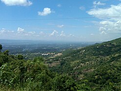
The island has five major ranges of mountains: The Central Range, known in the Dominican Republic as the Cordillera Central, spans the central part of the island, extending from the south coast of the Dominican Republic into northwestern Haiti, where it is known as the Massif du Nord. This mountain range boasts the highest peak in the Antilles, Pico Duarte at 3,101 meters (10,174 ft) above sea level.[54] The Cordillera Septentrional runs parallel to the Central Range across the northern end of the Dominican Republic, extending into the Atlantic Ocean as the Samaná Peninsula. The Cordillera Central and Cordillera Septentrional are separated by the lowlands of the Cibao Valley and the Atlantic coastal plains, which extend westward into Haiti as the Plaine du Nord (Northern Plain). The lowest of the ranges is the Cordillera Oriental, in the eastern part of the country.[55]
The Sierra de Neiba rises in the southwest of the Dominican Republic, and continues northwest into Haiti, parallel to the Cordillera Central, as the Montagnes Noires, Chaîne des Matheux and the Montagnes du Trou d'Eau. The Plateau Central lies between the Massif du Nord and the Montagnes Noires, and the Plaine de l'Artibonite lies between the Montagnes Noires and the Chaîne des Matheux, opening westward toward the Gulf of Gonâve, the largest gulf of the Antilles.[55]
The southern range begins in the southwesternmost Dominican Republic as the
The island has four distinct
Climate


Hispaniola's climate shows considerable variation due to its diverse mountainous topography, and is the most varied island of all the Antilles.[58] Except in the Northern Hemisphere summer season, the predominant winds over Hispaniola are the northeast trade winds. As in Jamaica and Cuba, these winds deposit their moisture on the northern mountains, and create a distinct rain shadow on the southern coast, where some areas receive as little as 400 millimetres (16 in) of rainfall, and have semi-arid climates. Annual rainfall under 600 millimetres (24 in) also occurs on the southern coast of Haiti's northwest peninsula and in the central Azúa region of the Plaine du Cul-de-Sac. In these regions, moreover, there is generally little rainfall outside hurricane season from August to October, and droughts are by no means uncommon when hurricanes do not come.[59] On the northern coast, in contrast, rainfall may peak between December and February, though some rain falls in all months of the year. Annual amounts typically range from 1,700 to 2,000 millimetres (67 to 79 in) on the northern coastal lowlands;[58] there is probably much more in the Cordillera Septentrional, though no data exist. The interior of Hispaniola, along with the southeastern coast centered around Santo Domingo, typically receives around 1,400 millimetres (55 in) per year, with a distinct season from May to October. Usually, this wet season has two peaks: one around May, the other around the hurricane season. In the interior highlands, rainfall is much greater, around 3,100 millimetres (120 in) per year, but with a similar pattern to that observed in the central lowlands.
The variations of temperature depend on altitude and are much less marked than rainfall variations in the island. Lowland Hispaniola is generally more hot and humid, with temperatures averaging 28 °C (82 °F). with high humidity during the daytime, and around 20 °C (68 °F) at night. At higher altitudes, temperatures fall steadily, so that frosts occur during the dry season on the highest peaks, where maxima are no higher than 18 °C (64 °F).
-
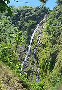 Salto de Jalda in Hato Mayor, Dominican Republic, the tallest waterfall in the Caribbean
 -

-
 Frosted alpine forest in Constanza, Dominican Republic
 -
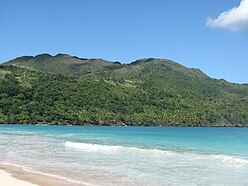 Tropical rainforest climate in Samana, Dominican Republic
 -
 Semi-arid climate in Pedernales, Hispaniolan dry forests, Dominican Republic and Haiti, the island of Hispaniola
 -
 Desert sand dunes of Baní, Dominican Republic
 -
 Cordillera Central in the Dominican Republic has the highest elevation of the Caribbean
 -
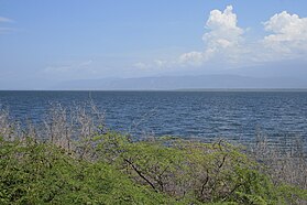 Lake Enriquillo, Dominican Republic and Haiti, the island of Hispaniola
 -
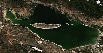 saltwater lake- hypersaline lake in the Dominican Republic. Lake Enriquillo is located in Enriquillo wetlands, Lake Enriquillo is the largest lake in both the Dominican Republic and Hispaniola, as well as the entire Caribbean. It is also the lowest point for an island country and Lake Enriquillo do also borders Haitiin the north west area of the lake on the island of Hispaniola
 -
 Yaque del Norte river, Dominican Republic
 -
 Oviedo Lake in Pedernales, Dominican Republic
 -
 Hispaniolan moist forests, hills north of Santiago de los Caballeros, Dominican Republic and Haiti, the island of Hispaniola
 -
 Hispaniolan pine forests, Hispaniolan pine forest as seen from Pico Duarte, Dominican Republic and Haiti, the island of Hispaniola
 -


_Saman%C3%A1,_DR.JPG)
.JPG)


Fauna
There are many
Flora
The island has four distinct

In Haiti, deforestation has long been cited by scientists as a source of ecological crisis; the timber industry dates back to French colonial rule. Haiti has seen a dramatic reduction of forests due to the excessive and increasing use of charcoal as fuel for cooking. Various media outlets have suggested that the country has just 2% forest cover, but this has not been substantiated by research.[61]
Also extremely important are the rarely mentioned species of Pinguicula casabitoana (a carnivorous plant), Gonocalyx tetraptera, Gesneria sylvicola, Lyonia alaini and Myrcia saliana, as well as palo de viento (Didymopanax tremulus), jaiqui (Bumelia salicifolia), pino criciolio) (pino criciol), sangre de pollo (Mecranium amigdalinum) and palo santo (Alpinia speciosa).
According to reports in the Dominican Republic and Haiti, the flora in this naturally protected area consists of 621 species of vascular plants, of which 153 are highly endemic to La Hispaniola. The most prominent endemic species of flora that abound in the area are Ebano Verde (green ebony), Magnolia pallescens, a highly endangered hardwood.
Recent in-depth studies of satellite imagery and environmental analysis regarding forest classification conclude that Haiti actually has approximately 30% tree cover;[62] this is, nevertheless, a stark decrease from the country's 60% forest cover in 1925. The country has been significantly deforested over the last 50 years, resulting in the desertification of many portions of Haitian territory. Haiti's poor citizens use cooking fires often, and this is a major culprit behind the nation's loss of trees. Haitians use trees as fuel either by burning the wood directly, or by first turning it into charcoal in ovens. Seventy-one percent of all fuel consumed in Haiti is wood or charcoal.[63] Haiti's government began establishing protected areas across the country in 1968. These 26 areas today represent nearly 7 per cent of the country's land and 1.5 per cent of its waters.[64]
In the Dominican Republic, the forest cover has increased. In 2003, the Dominican Republic's forest cover had been reduced to 32% of its land area, but by 2011, forest cover had increased to nearly 40%. The success of the Dominican forest growth is due to several Dominican government policies and private organizations for the purpose of reforesting, and a strong educational campaign that has resulted in increased awareness by the Dominican people of the importance of forests for their welfare and other forms of life on the island.[65]
Demographics


Hispaniola is the most populous Caribbean island with a combined population of 23 million inhabitants as of July 2023[update].[66]
The Dominican Republic is a

.jpg)
Haiti is a Creole-speaking nation of roughly 11.7 million people. Although French is spoken as a primary language by the educated and wealthy minority, virtually the entire population speaks Haitian Creole, one of several French-derived creole languages. Roman Catholicism is the dominant religion, practiced by more than half the population, although in some cases in combination with Haitian Vodou faith. Another 25% of the populace belong to Protestant churches.[67]
Ethnic composition
The ethnic composition of the Dominican population is 73% mixed ethnicity,[68] 16% white and 11% black. Descendants of early Spanish settlers and of black slaves from West Africa constitute the two main racial strains.
The ethnic composition of Haiti is estimated to be 95% black and 5% white and Mulatto.
In recent times, Dominican and Puerto Rican researchers identified in the current Dominican population the presence of genes belonging to the aborigines of the Canary Islands (commonly called Guanches).[69] These genes also have been detected in Puerto Rico.[70]
Economics

The island has the largest economy in the Greater Antilles; however, most of the economic development is found in the Dominican Republic, the Dominican economy being nearly 800% larger than the Haitian economy. As of 2018[update], the estimated annual per capita income is US$868 in Haiti and US$8,050 in the Dominican Republic.[71][72]
The divergence between the level of economic development in Haiti and the Dominican Republic makes its border the highest contrast of all western land borders.[73]
Natural resources
The island also has an economic history and current day interest and involvement in precious metals. In 1860, it was observed that the island contained a large supply of gold, which the early Spaniards had hardly developed.[74] By 1919, Condit and Ross noted that much of the island was covered by government granted concessions for mining different types of minerals. Besides gold, these minerals included silver, manganese, copper, magnetite, iron and nickel.[75]
Mining operations in 2016 have taken advantage of the
Between
Human development
This is a list of Dominican Republic and Haiti regions by Human Development Index as of 2018.[78]


| Rank | Region | 2018 HDI | Country |
|---|---|---|---|
| High human development | |||
| 1 | South Metro | 0.764 | Dominican Republic |
| 2 | Cibao North | 0.755 | Dominican Republic |
| 3 | North-East | 0.745 | Dominican Republic |
| 4 | Valdesia | 0.744 | Dominican Republic |
| 5 | Center | 0.737 | Dominican Republic |
| 6 | Yuma | 0.728 | Dominican Republic |
| 7 | Enriquillo | 0.706 | Dominican Republic |
| Medium human development | |||
| 8 | El Valle | 0.697 | Dominican Republic |
| 9 | North-West | 0.694 | Dominican Republic |
| Low human development | |||
| 10 | Ouest Metro | 0.535 | Haiti |
| 11 | North | 0.516 | Haiti |
| 12 | North-West | 0.493 | Haiti |
| 13 | North-East | 0.492 | Haiti |
| 14 | South | 0.487 | Haiti |
| 15 | South-East | 0.481 | Haiti |
| 16 | Grande-Anse | 0.471 | Haiti |
| 17 | Artibonite | 0.469 | Haiti |
| 18 | Centre | 0.454 | Haiti |
See also
- Casa de Contratación
- Dominican Republic–Haiti relations
- Geology of the Dominican Republic
- Geology of Haiti
- History of the Caribbean
- Spanish colonization of the Americas
- Spanish West Indies
- List of divided islands
References
- ^ "The World Factbook — Central Intelligence Agency". cia.gov. Archived from the original on June 13, 2007.
- ^ Haiti & The Dominican Republic IMF population estimates.
- ^ "Hispaniola". The American Heritage Dictionary of the English Language (5th ed.). HarperCollins. Retrieved July 22, 2019.
- ^ "Hispaniola". Collins English Dictionary. HarperCollins. Retrieved July 22, 2019.
- ^ "Hispaniola". Merriam-Webster.com Dictionary. Retrieved July 22, 2019.
- ^ "Hispaniola". Lexico UK English Dictionary. Oxford University Press. Archived from the original on December 2, 2020.
- Taino: Ayiti or Quisqueya)
- ^ Anglería, Pedro Mártir de (1949). Décadas del Nuevo Mundo, Tercera Década, Libro VII (in Spanish). Buenos Aires: Editorial Bajel.
- ^ Las Casas, Fray Bartolomé de (1966). Apologética Histórica Sumaria (in Spanish). Mexico: UNAM.
- ^ "Embassy of the Dominican Republic, in the United States". Archived from the original on May 24, 2007. Retrieved February 27, 2009.
- ^ a b "Haiti". Central Intelligence Agency. October 6, 2021 – via CIA.gov.
- .
- Smithsonian Magazine. Retrieved January 24, 2008.
- ^ Sauer, Carl Ortwin (1966). The Early Spanish Main. University of California Press. pp. 37–48.
- JSTOR 41849817.
- ^ "Quam protinus Hispanam dixi": Epistola De Insulis Nuper Repertis (Letter to Lord Raphael Sanchez, March 14, 1493).
- ^ ISBN 978-0-8203-2157-8.
- ISBN 978-0-8130-0902-5. Retrieved April 12, 2015.
- ISBN 978-9945-469-97-4. Retrieved June 15, 2015.
- ^ Lancer, Jalisco. "The Conflict Between Haiti and the Dominican Republic". allempires.com. Retrieved November 13, 2018.
- ^ "Haiti – Historical Flags". Flags of the World. Archived from the original on May 5, 2005. Retrieved December 24, 2007.
- PMID 33361817.
- ^ ProQuest 897718111.
- ^ a b c d e f g h i j k l m n Corbett, Bob (1995). "The History of Haiti". Retrieved November 20, 2018.
- – via Credo.
- ISSN 0362-4331. Retrieved December 24, 2020.
- ^ PMID 33361817.
- ISBN -9781412957380.
- ^ a b Cook, Noble David (2005). "Taino (Arawak) Indians". Encyclopedia of Genocide and Crimes Against Humanity. 3 – via GVRL.
- ^ Morison, Samuel Eliot (1974). The European Discovery of America: The Southern Voyages. Oxford University Press. pp. 79–80.
- ISBN 0-521-35097-2.
- ^ Centre, UNESCO World Heritage. "Colonial City of Santo Domingo". whc.unesco.org. Retrieved October 4, 2018.
- ^ JSTOR 20058872.
- ^ "The Early Trans-Atlantic Slave Trade: Nicolas Ovando · African Laborers for a New Empire: Iberia, Slavery, and the Atlantic World · Lowcountry Digital History Initiative". ldhi.library.cofc.edu. Retrieved October 4, 2018.
- ^ a b c Columbus, Ferdinand (1959). The Life of the Admiral Christopher Columbus by his son Ferdinand. New Brunswick: Rutgers, The State University. pp. 76–77, 83, 87.
- ^ a b Floyd, Troy (1973). The Columbus Dynasty in the Caribbean, 1492–1526. Albuquerque: University of New Mexico Press. pp. 44, 50, 57–58, 74.
- ISBN 1885509014.
- ^ ISBN 978-0-226-35168-1.
- ^ "History of Smallpox – Smallpox Through the Ages" Archived March 14, 2016, at the Wayback Machine. Texas Department of State Health Services.
- ISBN 0-8263-2871-7.
- ^ S, Rosenbaum S. Alan. Is the Holocaust Unique?: Perspectives on Comparative Genocide. Boulder, CO: Westview Press, 2018. Page 302,313.
- ^ a b Stannard, David E. (October 14, 1993). "American holocaust : the conquest of the New World". New York : Oxford University Press – via Internet Archive.
- ^ S2CID 143561036– via Taylor and Francis+NEJM.
- ^ Multiple sources:
- Thornton, Russel (1987). American Indian holocaust and survival : a population history since 1492. Norman: ISBN 978-0-8061-2074-4.
- Churchill, Ward, A Little Matter of Genocide: Holocaust and Denial in the Americas, 1492 to the Present, City Lights, 1997, 381 pages, p. 86, ISBN 978-0-87286-323-1
- Sheri P. Rosenberg, "Genocide Is a Process, Not an Event," Genocide Studies and Prevention 7, 1 (April 2012): 16–23. © 2012 Genocide Studies and Prevention. doi: 10.3138/gsp.7.1.16
- David Moshman (2007) Us and Them: Identity and Genocide, Identity: An International Journal of Theory and Research, 7:2, p. 125, DOI: 10.1080/15283480701326034,
- Alexander Laban Hinton, "Critical Genocide Studies," Genocide Studies and Prevention 7, 1 (April 2012): 4–15. © 2012 Genocide Studies and Prevention. doi: 10.3138/gsp.7.1.4, p. 11
- Keegan, William F., "Destruction of the Taino" in Archaeology. January/February 1992, pp. 51–56.
- Grenke, Arthur. God, greed, and genocide: The Holocaust through the centuries. New Academia Publishing, LLC, 2005. pp. 141–143, 200.
- Rosenbaum, Alan S. Is the Holocaust unique?: perspectives on comparative genocide. Routledge, 2018. p. 302.
- Donald Bloxham, A. Dirk Moses, The Oxford Handbook of Genocide Studies, OXFORD UNIVERSITY press, 2010, p. 310.
- Norman M Naimark, Genocide a world history, OXFORD UNIVERSITY press, 2017, p. 39.
- Jones, Adam. 2006. Genocide: a comprehensive introduction. London: Routledge. pp. 108–111.
- Thornton, Russel (1987). American Indian holocaust and survival : a population history since 1492. Norman:
- ^ Sugar Cane: Past and Present, Peter Sharpe "Ethnobotanical Leaflets". Archived from the original on May 18, 2008. Retrieved July 15, 2008.
- ISBN 0-394-71502-0.
- ^ a b "THE BUCCANEERS IN THE WEST INDIES IN THE XVII CENTURY - Chapter Four". www.thepirateking.com.
- ^ "Hispaniola Article". Britannica.com. Retrieved January 4, 2014.
- ^ "Dominican Republic 2014". Retrieved April 24, 2014.
- ISBN 0226675831
- ISBN 1-888799-79-X.
- ^ ISBN 9780674060197
- ^ "The World Factbook — Central Intelligence Agency". cia.gov. November 18, 2021.
- ^ "El Pico Duarte es apenas 4 metros más alto que La Pelona" (in Spanish). ojala.do. 2021. Retrieved July 26, 2022.
- ^ ISBN 9781468485370.
- ^ "Caribbean: Island of Hispaniola | Ecoregions | WWF". World Wildlife Fund. Retrieved December 6, 2018.
- ^ "Highest And Lowest Points Of Countries Of The World". WorldAtlas. May 20, 2021.
- ^ .
- doi:10.3354/cr00856.
- ^ "The island of Hispaniola in the Caribbean". World Wildlife Fund. Retrieved October 4, 2018.
- ^ O'Connor, M. R., ed. (October 13, 2016). "One of the Most Repeated Facts about Haiti is a Lie". Vice News.
- ^ "Haiti is Covered with Trees". EnviroSociety. Tarter, Andrew. May 19, 2016. Retrieved May 19, 2016.
- ^ "After the earthquake: Haiti's deforestation needs attention". Christian Science Monitor.
- ^ "In Haiti, communities take aim at deforestation". June 3, 2021.
- ^ "República Dominicana aumenta su cobertura boscosa a 39.7% - Fundación Global Democracia y Desarrollo".
- ^ "World Population Prospects, 2023 Revision". United Nations Department of Economic and Social Affairs, Population Division, Population Estimates and Projections Section. July 11, 2022. Retrieved February 10, 2023.
- ^ "The World Factbook". Cia.gov. November 22, 2021.
- ^ "DOMINICAN REPUBLIC". Encyclopedia of the Nations.
- ^ "Un estudio descubre la presencia de genes guanches en la República Dominicana | soitu.es". www.soitu.es.
- ^ "La Comunidad » DOCUMENTALES GRATIS » UN ESTUDIO DEL GENOMA TAINO Y GUANCHE. ADN o DNA. Primera parte". February 6, 2010. Archived from the original on February 6, 2010.
- ^ Bello, Marisol (January 21, 2010). "Hispaniola comparison". USA Today. Retrieved October 9, 2016.
- ^ "GDP per capita (current US$) - Haiti | Data". data.worldbank.org. Retrieved April 5, 2020.
- ^ Gibson, Carrie (October 7, 2013). "The Dominican Republic and Haiti: one island riven by an unresolved past | Carrie Gibson". the Guardian. Retrieved November 13, 2018.
- ^ Courtney, W.S. (1860). The Gold Fields of St. Domingo. New York: Anson P. Norton. pp. 123–125.
- ^ Condit, D. Dale; Ross, Clyde P. (1921). Economic Geology, Chapter X, in A Geological Reconnaissance of the Dominican Republic. Washington: United States Geological Survey. p. 228.
- ^ "Pueblo Viejo Gold Mine, Dominican Republic". mining-technology.com. Retrieved December 28, 2016.
- ^ "Cerro de Maimon". Perilya.com. Retrieved December 28, 2016.
- ^ "Sub-national HDI - Area Database - Global Data Lab". hdi.globaldatalab.org. Retrieved September 13, 2018.
Further reading
- ISBN 978-0-8071-7578-1
- Altman, Ida and David Wheat, eds. The Spanish Caribbean & the Atlantic World in the Long Sixteenth Century. Lincoln: University of Nebraska Press 2019.
- Deagan, Kathleen and José María Cruxent. Columbus's Outpost Among the Taínos. New Haven: Yale University Press 2002.
- Floyd, Troy S. The Columbus Dynasty in the Caribbean, 1492–1526. Albuquerque: University of New Mexico Press 1973.
- Livi-Bacci, Maximo. Return to Hispaniola: Assessing a Demographic Catastrophe. Hispanic American Historical Review83, no. 1 (2003): 3–51.
- Rodríguez Morel, Genaro. "The Sugar Economy of Española in the Sixteenth Century" in Tropical Bablyons: Sugar and the Making of the Atlantic World. 1450–1680, ed. Stuart B. Schwartz. Chapel Hill: University of North Carolina Press 2004.
- Sauer, Carl O.. The Early Spanish Main. Berkeley and Los Angeles: University of California Press 1966.
- Tibesar, Antonine S. The Franciscan Province of the Holy Cross of Española, 1505–1559. The Americas13, no. 4 (1957)
- Wilson, Samuel M. Hispaniola: Caribbean Chiefdoms in the Age of Columbus. Tuscaloosa: University of Alabama Press 1990.
External links
 Definitions from Wiktionary
 Media from Commons
 Texts from Wikisource
 Travel information from Wikivoyage
 Data from Wikidata
- Google maps
- Map of the Islands of Hispaniola and Puerto Rico from 1639
- The Kraus Collection of Sir Francis Drake at the Library of Congress contains primary materials on Hispaniola.
Dominican Republic articles | |||||
|---|---|---|---|---|---|
| History |
|  | |||
| Geography | |||||
| Politics |
| ||||
| Economy | |||||
| Society |
| ||||
| 100,000 km2 (38,610 sq mi) and greater | ||
|---|---|---|
| 20,000–99,999 km2 (7,722–38,610 sq mi) |
| |
| International | |
|---|---|
| National | |
| Other | |