
Gilsum, New Hampshire
Gilsum, New Hampshire | ||
|---|---|---|
Town | ||
FIPS code 33-29220 | | |
| GNIS feature ID | 0873605 | |
| Website | gilsum-nh | |
Gilsum is a town in Cheshire County, New Hampshire, United States. The population was 752 at the 2020 census.[2] Home to Bear's Den Natural Area, Gilsum includes Gilsum Lower Village.
History
The land was originally named "Boyle" after Richard Boyle, Earl of Burlington, when the land was granted by the Masonian Proprietors in 1752, but ongoing hostilities during the French and Indian War prevented settlement. When the grant lapsed, the town was rechartered by Governor Benning Wentworth on July 13, 1763, as Gilsum, in a portmanteau of the surnames of two proprietors, Samuel Gilbert and his son-in-law, Thomas Sumner. It was first settled in 1764 by Josiah Kilburn from Hebron, Connecticut.[3]
The
The town contains the Stone Arch Bridge, completed in 1863 with the highest vault (36 feet, 6 inches) of any mortarless bridge in New Hampshire. In 1989, it was added to the National Register.
-
 Main Street c. 1910
 -
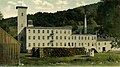 Woolen mill in 1911
 -
 Polley Bridge in 1907
 -
 The Ashuelot Hotel c. 1896


Geography
According to the United States Census Bureau, the town has a total area of 16.7 square miles (43.2 km2), of which 0.02 square miles (0.06 km2) are water, comprising 0.13% of the town.[1] The highest point in Gilsum is an unnamed hill along the town's eastern boundary, where the elevation reaches 1,657 feet (505 m) above sea level. Gilsum is drained by the Ashuelot River and lies fully within the Connecticut River watershed.[5]
The town is served by New Hampshire Route 10.
Adjacent municipalities
Demographics
| Census | Pop. | Note | %± |
|---|---|---|---|
| 1790 | 298 | — | |
| 1800 | 484 | 62.4% | |
| 1810 | 513 | 6.0% | |
| 1820 | 601 | 17.2% | |
| 1830 | 412 | −31.4% | |
| 1840 | 656 | 59.2% | |
| 1850 | 668 | 1.8% | |
| 1860 | 676 | 1.2% | |
| 1870 | 590 | −12.7% | |
| 1880 | 663 | 12.4% | |
| 1890 | 643 | −3.0% | |
| 1900 | 590 | −8.2% | |
| 1910 | 470 | −20.3% | |
| 1920 | 439 | −6.6% | |
| 1930 | 506 | 15.3% | |
| 1940 | 491 | −3.0% | |
| 1950 | 578 | 17.7% | |
| 1960 | 528 | −8.7% | |
| 1970 | 570 | 8.0% | |
| 1980 | 652 | 14.4% | |
| 1990 | 745 | 14.3% | |
| 2000 | 777 | 4.3% | |
| 2010 | 813 | 4.6% | |
| 2020 | 752 | −7.5% | |
| U.S. Decennial Census[2][6] | |||
As of the
There were 310 households, out of which 26.5% had children under the age of 18 living with them, 58.7% were married couples living together, 8.7% had a female householder with no husband present, and 29.0% were non-families. 23.9% of all households were made up of individuals, and 6.5% had someone living alone who was 65 years of age or older. The average household size was 2.48 and the average family size was 2.90.
In the town, the population was spread out, with 22.3% under the age of 18, 5.0% from 18 to 24, 30.0% from 25 to 44, 31.9% from 45 to 64, and 10.8% who were 65 years of age or older. The median age was 41 years. For every 100 females, there were 98.2 males. For every 100 females age 18 and over, there were 104.1 males.
The median income for a household in the town was $43,359, and the median income for a family was $50,469. Males had a median income of $35,150 versus $24,205 for females. The
Sites of interest
- Gilsum Historical Society Museum
- New Hampshire Historical Marker No. 168: Gilsum Stone Arch Bridge
Notable people
- Lucy Mack (1775–1856), mother of the Latter Day Saint movement founder Joseph Smith
- Daniel Whitney(1795–1862), Wisconsin businessman, pioneer
References
- ^ a b "2021 U.S. Gazetteer Files – New Hampshire". United States Census Bureau. Retrieved November 3, 2021.
- ^ a b c "Gilsum town, Cheshire County, New Hampshire: 2020 DEC Redistricting Data (PL 94-171)". U.S. Census Bureau. Retrieved November 3, 2021.
- ^ Coolidge, Austin J.; John B. Mansfield (1859). A History and Description of New England. Boston, Massachusetts: A.J. Coolidge. p. 502.
coolidge mansfield history description new england 1859.
- ^ History of Gilsum, New Hampshire
- ^ Foster, Debra H.; Batorfalvy, Tatianna N.; Medalie, Laura (1995). Water Use in New Hampshire: An Activities Guide for Teachers. U.S. Department of the Interior and U.S. Geological Survey.
- ^ "Census of Population and Housing". Census.gov. Retrieved June 4, 2016.
- ^ "U.S. Census website". United States Census Bureau. Retrieved January 31, 2008.
External links
- Official website
- Gilsum Public Library
- Gilsum Recreation Committee community website
- New Hampshire Economic and Labor Market Information Bureau Profile
Places adjacent to Gilsum, New Hampshire | |
|---|---|
 | ||||
| Towns | ||||
| CDPs | ||||
Other villages | ||||
| ||||
| International | |
|---|---|
| National | |