
Nelson, New Hampshire
Nelson, New Hampshire | ||
|---|---|---|
Town | ||
FIPS code 33-50580 | | |
| GNIS feature ID | 0873673 | |
| Website | www | |
Nelson is a town in Cheshire County, New Hampshire, United States. The population was 629 at the 2020 census,[2] down from 729 at the 2010 census.[3] Nelson includes the village of Munsonville.
History

Originally named "
Located on the height of land separating the
Nelson is the home of a popular Monday night
-
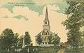 Soldiers' monument and church c. 1910
 -
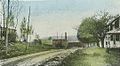 L. J. Colony Chair Co. at Munsonville c. 1914
 -
 Old sawmill at Munsonville c. 1914


Geography
Nelson is located in the eastern part of Cheshire County, in southwestern New Hampshire. Its eastern border is the Hillsborough County line. According to the United States Census Bureau, the town has a total area of 23.3 square miles (60.3 km2), of which 21.9 square miles (56.7 km2) are land and 1.4 square miles (3.5 km2) are water, comprising 5.88% of the town.[1] The eastern part of the town drains towards the Contoocook River, a tributary of the Merrimack River and part of the Gulf of Maine watershed, while the western part of the town feeds tributaries of the Ashuelot River, part of the Connecticut River watershed draining to Long Island Sound. Spoonwood Pond and part of Nubanusit Lake are in the east. Part of Silver Lake is in the south, and part of Granite Lake is in the north. The village of Munsonville is located at the outlet of Granite Lake. The highest point in Nelson is the summit of Osgood Hill (also known as Nelson Pinnacle), with an elevation of 2,253 feet (687 m) above sea level.
The town is crossed by the Monadnock-Sunapee Greenway, a 50-mile-long (80 km) hiking trail that traverses the highlands of southern New Hampshire from Mount Monadnock in Jaffrey to Mount Sunapee in Newbury. The trail passes directly through the center of Nelson.
The town is crossed by New Hampshire Route 9.
Adjacent municipalities
- Stoddard (north)
- Antrim (northeast)
- Hancock (east)
- Harrisville (south)
- Roxbury (southwest)
- Sullivan (west)
Demographics
| Census | Pop. | Note | %± |
|---|---|---|---|
| 1790 | 721 | — | |
| 1800 | 977 | 35.5% | |
| 1810 | 1,076 | 10.1% | |
| 1820 | 907 | −15.7% | |
| 1830 | 875 | −3.5% | |
| 1840 | 835 | −4.6% | |
| 1850 | 750 | −10.2% | |
| 1860 | 699 | −6.8% | |
| 1870 | 744 | 6.4% | |
| 1880 | 438 | −41.1% | |
| 1890 | 332 | −24.2% | |
| 1900 | 295 | −11.1% | |
| 1910 | 231 | −21.7% | |
| 1920 | 171 | −26.0% | |
| 1930 | 162 | −5.3% | |
| 1940 | 282 | 74.1% | |
| 1950 | 231 | −18.1% | |
| 1960 | 222 | −3.9% | |
| 1970 | 304 | 36.9% | |
| 1980 | 442 | 45.4% | |
| 1990 | 535 | 21.0% | |
| 2000 | 634 | 18.5% | |
| 2010 | 729 | 15.0% | |
| 2020 | 629 | −13.7% | |
| U.S. Decennial Census[2][10] | |||
As of the census of 2010, there were 729 people, 303 households, and 208 families residing in the town. The population density was 33.3 inhabitants per square mile (12.9/km2). There were 460 housing units, of which 157, or 34.1%, were vacant. 144 of the vacant units were for seasonal or recreational use. The racial makeup of the town was 97.7%
Of the 303 households in the town, 26.4% had children under the age of 18 living with them, 52.8% were headed by married couples living together, 8.9% had a female householder with no husband present, and 31.4% were non-families. 24.8% of all households were made up of individuals, and 8.6% were someone living alone who was 65 years of age or older. The average household size was 2.41, and the average family size was 2.79.[11]
19.1% of the town population were under the age of 18, 9.1% were from 18 to 24, 20.1% were from 25 to 44, 35.3% were from 45 to 64, and 16.3% were 65 years of age or older. The median age was 46.2 years. For every 100 females, there were 105.9 males. For every 100 females age 18 and over, there were 102.1 males.[11]
For the period 2013–2017, the estimated median annual income for a household in the town was $71,500, and the median income for a family was $90,313. Male full-time workers had a median income of $48,000 versus $48,542 for females. The
Notable people
- Ursula Newell Emerson (1806–1888), missionary in Hawaii
- Alfred B. Kittredge (1861–1911), US senator from South Dakota
- Ralph Page (1903–1985), contra dance caller and authority on American folk dance
- May Sarton (1912–1995), poet, writer
References
- ^ a b "2021 U.S. Gazetteer Files – New Hampshire". United States Census Bureau. Retrieved November 4, 2021.
- ^ a b c "Nelson town, Cheshire County, New Hampshire: 2020 DEC Redistricting Data (PL 94-171)". U.S. Census Bureau. Retrieved November 4, 2021.
- ^ United States Census Bureau, American FactFinder, 2010 Census figures. Retrieved March 23, 2011.
- ^ Austin J. Coolidge & John B. Mansfield, A History and Description of New England; Boston, Massachusetts 1859
- ^ Alan F. Rumrill, The Power of Water: Munsonville from 1850-1950
- ^ "Contra Dances ?".
- ^ "Nelson contra dance". January 23, 2008.
- ^ "Contra, a 'best kept secret' : Locals gather for three-day folk dancing workshop in Durham". Archived from the original on March 4, 2016. Retrieved August 5, 2023.
- ^ "Nelson New Hampshire's Moment in the Guinness World Record Book". September 17, 2006.
- ^ "Census of Population and Housing". Census.gov. Retrieved June 4, 2016.
- ^ a b c "Profile of General Population and Housing Characteristics: 2010 Census Summary File 1 (DP-1): Nelson town, Cheshire County, New Hampshire". American Factfinder. U.S. Census Bureau. Archived from the original on February 13, 2020. Retrieved January 28, 2019.
- ^ "Selected Economic Characteristics: 2013-2017 American Community Survey 5-Year Estimates (DP03): Nelson town, Cheshire County, New Hampshire". American Factfinder. U.S. Census Bureau. Archived from the original on February 13, 2020. Retrieved January 28, 2019.
External links
- Official website
- Olivia Rodham Memorial Library
- Apple Hill Center for Chamber Music
- New Hampshire Economic and Labor Market Information Bureau Profile
Places adjacent to Nelson, New Hampshire | |
|---|---|
 | ||||
| Towns | ||||
| CDPs | ||||
Other villages | ||||
| ||||
| International | |
|---|---|
| National | |