
Greenville, New Hampshire
Greenville, New Hampshire | ||
|---|---|---|
Town | ||
FIPS code 33-31940 | | |
| GNIS feature ID | 0873613 | |
| Website | www | |
Greenville is a town in Hillsborough County, New Hampshire, United States. The population was 1,974 at the 2020 census,[2] down from 2,105 at the 2010 census.[3] It is located at the junctions of New Hampshire routes 31, 45, and 123.
History
Once a part of
Greenville once had a
-
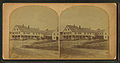 Columbian Hotel c. 1880
 -
 Greenville in 1886
 -
 View of the mills in 1886
 -
 East Main Street in 1919
 -
 B. & M. trestle c. 1915

.jpg)


Geography
According to the United States Census Bureau, the town has a total area of 6.9 square miles (17.8 km2), all of it recorded as land.[1] The Greenville CDP, which includes the town center, occupies the northern part of the town and has an area of 3.4 sq mi (8.8 km2). The Souhegan River passes through the town center.
Greenville's highest point is Barrett Hill, near the western border of the town, with an elevation of 1,270 feet (390 m) above sea level. The northern half of the town is drained by the Souhegan River, while the southern half is drained by tributaries of Walker Brook and Mason Brook, which flow south to the Squannacook River, a tributary of the Nashua River in Massachusetts. The entire town is within the Merrimack River watershed.[6]
Adjacent municipalities
- Wilton (north)
- Mason (east and south)
- New Ipswich (west)
- Temple (northwest)
Roadways
Four state highways traverse Greenville. NH Route 31 enters the state in Mason from Ashby, Massachusetts, on MA Route 31. NH 31 intersects NH 124 before entering Greenville. NH 31 runs north-south for the entire length of the town before entering Wilton to the north. The highway shares a right-of-way with NH Route 123 which intersects it and runs north to Pleasant Street. Pleasant Street is the main access road to downtown Greenville from NH 31 in the south. NH 123 continues on a left turn in downtown Greenville and runs south to New Ipswich and NH 124. Further down Main Street in Greenville is the beginning of NH Route 45, which runs northwest to Temple, ending at NH Route 101. NH Route 124 crosses the southwest corner of Greenville but intersects no other highways within the town limits.
Climate
According to the
| Climate data for Greenville, New Hampshire, 1991–2020 normals, extremes 2000–present | |||||||||||||
|---|---|---|---|---|---|---|---|---|---|---|---|---|---|
| Month | Jan | Feb | Mar | Apr | May | Jun | Jul | Aug | Sep | Oct | Nov | Dec | Year |
| Record high °F (°C) | 65 (18) |
70 (21) |
79 (26) |
92 (33) |
92 (33) |
100 (38) |
104 (40) |
104 (40) |
100 (38) |
94 (34) |
80 (27) |
76 (24) |
104 (40) |
| Mean maximum °F (°C) | 54.7 (12.6) |
54.5 (12.5) |
62.7 (17.1) |
76.5 (24.7) |
86.6 (30.3) |
89.5 (31.9) |
91.1 (32.8) |
87.7 (30.9) |
85.7 (29.8) |
74.9 (23.8) |
67.3 (19.6) |
56.1 (13.4) |
92.9 (33.8) |
| Mean daily maximum °F (°C) | 30.2 (−1.0) |
34.2 (1.2) |
41.5 (5.3) |
54.7 (12.6) |
66.3 (19.1) |
74.1 (23.4) |
79.4 (26.3) |
77.8 (25.4) |
70.4 (21.3) |
57.9 (14.4) |
46.3 (7.9) |
35.5 (1.9) |
55.7 (13.2) |
| Daily mean °F (°C) | 22.3 (−5.4) |
24.5 (−4.2) |
31.9 (−0.1) |
43.8 (6.6) |
54.3 (12.4) |
62.9 (17.2) |
68.8 (20.4) |
66.7 (19.3) |
59.7 (15.4) |
47.8 (8.8) |
37.9 (3.3) |
27.5 (−2.5) |
45.7 (7.6) |
| Mean daily minimum °F (°C) | 14.4 (−9.8) |
14.8 (−9.6) |
22.3 (−5.4) |
32.8 (0.4) |
42.4 (5.8) |
51.7 (10.9) |
58.2 (14.6) |
55.7 (13.2) |
48.9 (9.4) |
37.7 (3.2) |
29.5 (−1.4) |
19.6 (−6.9) |
35.7 (2.0) |
| Mean minimum °F (°C) | −4.1 (−20.1) |
−1.1 (−18.4) |
6.3 (−14.3) |
22.1 (−5.5) |
31.0 (−0.6) |
41.1 (5.1) |
48.7 (9.3) |
46.4 (8.0) |
34.9 (1.6) |
25.3 (−3.7) |
14.9 (−9.5) |
3.3 (−15.9) |
−7.0 (−21.7) |
| Record low °F (°C) | −20 (−29) |
−16 (−27) |
−10 (−23) |
10 (−12) |
24 (−4) |
32 (0) |
38 (3) |
38 (3) |
22 (−6) |
10 (−12) |
0 (−18) |
−10 (−23) |
−20 (−29) |
| Average precipitation inches (mm) | 3.42 (87) |
3.28 (83) |
4.25 (108) |
4.35 (110) |
3.73 (95) |
4.26 (108) |
3.64 (92) |
3.84 (98) |
4.25 (108) |
5.42 (138) |
4.11 (104) |
4.96 (126) |
49.51 (1,257) |
| Average snowfall inches (cm) | 19.2 (49) |
19.2 (49) |
15.7 (40) |
2.9 (7.4) |
0.0 (0.0) |
0.0 (0.0) |
0.0 (0.0) |
0.0 (0.0) |
0.0 (0.0) |
0.4 (1.0) |
1.9 (4.8) |
16.1 (41) |
75.4 (192.2) |
| Average precipitation days (≥ 0.01 in) | 9.0 | 7.2 | 8.6 | 9.3 | 10.9 | 10.5 | 9.0 | 8.4 | 7.9 | 9.4 | 8.7 | 9.2 | 108.1 |
| Average snowy days (≥ 0.1 in) | 6.1 | 5.4 | 4.2 | 1.2 | 0.0 | 0.0 | 0.0 | 0.0 | 0.0 | 0.2 | 1.2 | 4.0 | 22.3 |
| Source 1: NOAA[7] | |||||||||||||
| Source 2: National Weather Service (mean maxima and minima 2006–2020)[8] | |||||||||||||
Demographics
| Census | Pop. | Note | %± |
|---|---|---|---|
| 1880 | 1,072 | — | |
| 1890 | 1,255 | 17.1% | |
| 1900 | 1,608 | 28.1% | |
| 1910 | 1,374 | −14.6% | |
| 1920 | 1,346 | −2.0% | |
| 1930 | 1,319 | −2.0% | |
| 1940 | 1,236 | −6.3% | |
| 1950 | 1,280 | 3.6% | |
| 1960 | 1,385 | 8.2% | |
| 1970 | 1,587 | 14.6% | |
| 1980 | 1,988 | 25.3% | |
| 1990 | 2,231 | 12.2% | |
| 2000 | 2,224 | −0.3% | |
| 2010 | 2,105 | −5.4% | |
| 2020 | 1,974 | −6.2% | |
| U.S. Decennial Census[2][9] | |||
As of the
Of the 861 households, 30.1% had children under the age of 18 living with them, 42.9% were headed by married couples living together, 13.8% had a female householder with no husband present, and 37.6% were non-families. 29.3% of all households were made up of individuals, and 10.2% were someone living alone who was 65 years of age or older. The average household size was 2.44, and the average family size was 3.02.[10]
In the town, 23.2% of the population were under the age of 18, 8.0% were from 18 to 24, 23.3% from 25 to 44, 32.7% from 45 to 64, and 12.6% were 65 years of age or older. The median age was 41.6 years. For every 100 females, there were 98.6 males. For every 100 females age 18 and over, there were 96.7 males.[10]
For the period 2011–2015, the estimated median annual income for a household was $52,602, and the median income for a family was $63,850. The per capita income for the town was $24,457. 13.8% of the population and 8.6% of families were below the poverty line. 24.9% of the population under the age of 18 and 11.7% of those 65 or older were living in poverty.[11]
Notable people
- Henry Richardson (1917–1981), New Hampshire's first African American state legislator
- Brian Viglione (born 1979), drummer for The Dresden Dolls
See also
- Greenville Wildlife Park, a small zoo that closed in 2003
References
- ^ a b "2021 U.S. Gazetteer Files – New Hampshire". United States Census Bureau. Retrieved December 7, 2021.
- ^ a b c "Greenville town, Hillsborough County, New Hampshire: 2020 DEC Redistricting Data (PL 94-171)". U.S. Census Bureau. Retrieved December 7, 2021.
- ^ United States Census Bureau, U.S. Census website, 2010 Census figures. Retrieved March 23, 2011.
- ^ New Hampshire Economic and Labor Market Information Bureau Profile
- ^ Coolidge, Austin J.; John B. Mansfield (1859). A History and Description of New England. Boston, Massachusetts: A.J. Coolidge. pp. 574–575.
coolidge mansfield history description new england 1859.
- ^ Foster, Debra H.; Batorfalvy, Tatianna N.; Medalie, Laura (1995). Water Use in New Hampshire: An Activities Guide for Teachers. U.S. Department of the Interior and U.S. Geological Survey.
- ^ "U.S. Climate Normals Quick Access". National Oceanic and Atmospheric Administration. Retrieved August 3, 2022.
- ^ "NOAA Online Weather Data". National Weather Service. Retrieved August 3, 2022.
- ^ "Census of Population and Housing". Census.gov. Retrieved June 4, 2016.
- ^ a b c "Profile of General Population and Housing Characteristics: 2010 Census Summary File 1 (DP-1): Greenville town, Hillsborough County, New Hampshire". American Factfinder. U.S. Census Bureau. Archived from the original on February 13, 2020. Retrieved November 1, 2017.
- ^ "Selected Economic Characteristics: 2011-2015 American Community Survey 5-Year Estimates (DP03): Greenville town, Hillsborough County, New Hampshire". American Factfinder. U.S. Census Bureau. Archived from the original on February 13, 2020. Retrieved November 1, 2017.
External links
- Official website
- Chamberlin Free Public Library
- New Hampshire Economic and Labor Market Information Bureau Profile
Places adjacent to Greenville, New Hampshire | ||||||||||||||||
|---|---|---|---|---|---|---|---|---|---|---|---|---|---|---|---|---|
| ||||||||||||||||
 | ||||
| Towns | ||||
| CDPs | ||||
Other villages | ||||
| ||||
| Authority control databases: Geographic |
|---|