
Weare, New Hampshire
Weare, New Hampshire | ||
|---|---|---|
Town | ||
FIPS code 33-79780 | | |
| GNIS feature ID | 0873749 | |
| Website | www | |
Weare is a
.History

It was granted to veterans of the Canadian wars in 1735 by Governor Jonathan Belcher, who named it "Beverly-Canada" after their hometown, Beverly, Massachusetts. But the charter was ruled invalid because of a prior claim by the Masonian proprietors, who granted 6 square miles (16 km2) as "Hale's Town" to Ichabod Robie in 1749.[3] It was also known as "Robie's Town" or "Weare's Town" before being incorporated by Governor Benning Wentworth in 1764 as Weare, after Meshech Weare, who served as the town's first clerk and later went on to become New Hampshire's first governor.[4]
In 1834, Moses Cartland founded Clinton Grove Academy, the first
It would serve as the Weare school district from 1877 to 1938.On September 21, 1938, following several days of heavy rain, the
In response to the disaster and seasonal flooding, the
-
 Old bridge c. 1905
 -
 Baptist Church c. 1910
 -
 Boston & Maine Railroadstation in 1910
 -
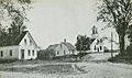
 East Weare c. 1910


Geography
According to the United States Census Bureau, the town has a total area of 60.1 square miles (155.7 km2), of which 59.1 square miles (153.0 km2) are land and 1.0 square mile (2.7 km2) are water, comprising 1.72% of the town.[1] Weare is drained by the Piscataquog River, which is impounded by Lake Horace in the northwest and by Everett Lake in the northeast. Via the Piscataquog, the town is entirely within the Merrimack River watershed. The three highest summits in Weare form a cluster near the center of town. From south to north, they are Mount Dearborn, at 1,211 feet (369 m) above sea level, Mine Hill 1,211 feet (369 m), and Mount Wallingford, approximately 1,210 feet (370 m).
The town is crossed by New Hampshire Route 77, New Hampshire Route 114 and New Hampshire Route 149.
Adjacent municipalities
- Henniker (north)
- Hopkinton (north)
- Dunbarton (east)
- Goffstown (southeast)
- New Boston (south)
- Francestown (southwest)
- Deering (west)
Demographics
| Census | Pop. | Note | %± |
|---|---|---|---|
| 1790 | 1,924 | — | |
| 1800 | 2,517 | 30.8% | |
| 1810 | 2,634 | 4.6% | |
| 1820 | 2,781 | 5.6% | |
| 1830 | 2,430 | −12.6% | |
| 1840 | 2,375 | −2.3% | |
| 1850 | 2,435 | 2.5% | |
| 1860 | 2,310 | −5.1% | |
| 1870 | 2,092 | −9.4% | |
| 1880 | 1,829 | −12.6% | |
| 1890 | 1,550 | −15.3% | |
| 1900 | 1,553 | 0.2% | |
| 1910 | 1,325 | −14.7% | |
| 1920 | 1,173 | −11.5% | |
| 1930 | 1,287 | 9.7% | |
| 1940 | 1,367 | 6.2% | |
| 1950 | 1,345 | −1.6% | |
| 1960 | 1,420 | 5.6% | |
| 1970 | 1,851 | 30.4% | |
| 1980 | 3,232 | 74.6% | |
| 1990 | 6,193 | 91.6% | |
| 2000 | 7,776 | 25.6% | |
| 2010 | 8,785 | 13.0% | |
| 2020 | 9,092 | 3.5% | |
| U.S. Decennial Census[2][6] | |||
As of the
There were 2,618 households, out of which 48.2% had children under the age of 18 living with them, 71.0% were married couples living together, 5.6% had a female householder with no husband present, and 19.1% were non-families. 13.4% of all households were made up of individuals, and 2.6% had someone living alone who was 65 years of age or older. The average household size was 2.97 and the average family size was 3.28.
In the town, the population was spread out, with 32.0% under the age of 18, 5.7% from 18 to 24, 36.8% from 25 to 44, 20.7% from 45 to 64, and 4.7% who were 65 years of age or older. The median age was 34 years. For every 100 females, there were 101.1 males. For every 100 females age 18 and over, there were 99.5 males.
The median income for a household in the town was $59,924, and the median income for a family was $62,661. Males had a median income of $38,986 versus $27,643 for females. The
Education
Weare has one elementary school, Center Woods Elementary School, serving children in pre-kindergarten through third grade,[8] located on Center Road.
Weare Middle School, located on East Road in Weare center, serves children from fourth grade through eighth grade.[8]
High school students in Weare and Henniker attend John Stark Regional High School.
Notable people
- Elma Gove (1832–1921), painter
- Gene Robinson (born 1947), ninth Episcopal bishop of the Diocese of New Hampshire; known for being the first openly gay priest to be consecrated a bishop in a major Christian denomination believing in the historic episcopate
- U.S. Supreme Court
See also
- New Hampshire Historical Marker No. 143: East Weare Village
- New Hampshire Historical Marker No. 192: Piscataquog River Mill Sites
References
- ^ a b "2021 U.S. Gazetteer Files – New Hampshire". United States Census Bureau. Retrieved December 10, 2021.
- ^ a b c "Weare town, Hillsborough County, New Hampshire: 2020 DEC Redistricting Data (PL 94-171)". U.S. Census Bureau. Retrieved December 10, 2021.
- ^ Warren Brown, Volume 1 of History of Hampton Falls, N.H. Rumford Press, 1900.
- ^ Austin J. Coolidge & John B. Mansfield, A History and Description of New England; Boston, Massachusetts 1859
- ^ History of Weare, Hillsborough County, New Hampshire; J.W. Lewis & Company, Philadelphia 1885
- ^ "Census of Population and Housing". Census.gov. Retrieved June 4, 2016.
- ^ "U.S. Census website". United States Census Bureau. Retrieved January 31, 2008.
- ^ a b "Student and Parent Handbook, 2022-2023". Weare School District. June 15, 2022. Retrieved January 10, 2023.
External links
- Official website
- Weare profile, New Hampshire Economic and Labor Market Information Bureau
Places adjacent to Weare, New Hampshire | |
|---|---|
 | ||||
| Towns | ||||
| CDPs | ||||
Other villages | ||||
| ||||
| International | |
|---|---|
| National | |