
Joychandi Pahar
| Joychandi Pahar | |
|---|---|
 Joychandi Pahar | |
| Geography | |
| Location | Adra road, Raghunathpur, Purulia district, West Bengal, India https://goo.gl/maps/PFiofMGKsBvMcVUb6 |
| Parent range | Chota Nagpur Plateau |
Joychandi Pahar is a hill which is a popular tourist attraction in the
Geography

5miles
Reservoir
Hill
M: Municipal town, CT: census town, R: rural/ urban centre, H: historical/ religious centre, T: tourist centre
Owing to space constraints in the small map, the actual locations in a larger map may vary slightly

Location
Joychandi Pahar, Raghunathpur is located at 23°33′N 86°40′E / 23.55°N 86.67°E.[2] It has an average elevation of 155 m (509 ft).
Area overview
Purulia district forms the lowest step of the Chota Nagpur Plateau. The general scenario is undulating land with scattered hills.[3]Raghunathpur subdivision occupies the north-western part of the district. 83.80% of the population of the subdivision lives in rural areas. However, there are pockets of urbanization and 16.20% of the population lives in urban areas. There are 14 census towns in the subdivision.[4] It is presented in the map given alongside. There is a coal mining area around Parbelia[5] and two thermal power plants are there – the 500 MW Santaldih Thermal Power Station[6] and the 1200 MW Raghunathpur Thermal Power Station. The subdivision has a rich heritage of old temples, some of them belonging to the 11th century or earlier. The Banda Deul is a monument of national importance.[7][8] The comparatively more recent in historical terms, Panchkot Raj has interesting and intriguing remains in the area.[9][10]
Note: The map alongside presents some of the notable locations in the subdivision. All places marked in the map are linked in the larger full screen map.
Festival
Every Year A Festival is held in the foothills after the Christmas and this Festival usually continues to 1 January or 2 January. This Festival often becomes tourist attraction and also motivates local artists. This Festival Gives all local artists to show their skills. The Festival Often referred as Joychandi Pahar Pariyatan Utsav। [11]
Fiction
The Bengali film directed by Satyajit Ray, Hirak Rajar Deshe was mostly shot in this mountain area.[12]
Gallery
-
 Joychandi pahar
 -
 Inside view of the Joychandi Pahar Railway's station
 -
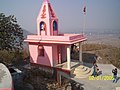
 Temple at the hilltop of Jaychandi pahar, Purulia
 -
 Goddess Joychandi Temple.( Locally known as "Joychandi Matar Mandir" )
 -
 Hanuman Temple in the Joychandi Mountain
 -
 Joychandi Hill Railway Station


References
- ^ "Purulia". Places of Interest. bongodarshan. Archived from the original on 7 October 2007. Retrieved 5 September 2007.
- ^ Falling Rain Genomics, Inc - Raghunathpur
- ^ Houlton, Sir John, Bihar, the Heart of India, 1949, p. 170, Orient Longmans Ltd.
- ^ "District Statistical Handbook 2014 Purulia". Tables 2.1, 2.2. Department of Planning and Statistics, Government of West Bengal. Retrieved 12 January 2020.
- ^ "Area wise Closed User Group (CUG) Telephone Numbers" (PDF). Sodepur Area. Eastern Coalfields Limited. Retrieved 11 August 2018.
- ^ "Santaldih Thermal Power Station - WBPDCL". WBPDCL. Archived from the original on 11 January 2010. Retrieved 24 August 2011.
- ^ "Old temple at Banda (locally known as deul)". ASI, Kolkata Circle. Retrieved 23 January 2020.
- ^ "List of Ancient Monuments and Archaeological Sites and Remains of West Bengal - Archaeological Survey of India". Item no. 134. ASI. Retrieved 25 January 2020.
- ^ "Capital in shambles: Garh Panchakot, Purulia". Heritage in Peril. Retrieved 1 December 2016.
- ^ "Historical ruins". Trek Earth. Retrieved 1 December 2016.
- ^ ""হীরক রাজার দেশ "জয়চন্ডী পাহাড় পর্যটন উৎসব – KHONJKHOBOR". Retrieved 10 November 2019.
- ^ মণ্ডল, শুভ্রপ্রকাশ. "পর্যটনে জোয়ার আনতে বড় পর্দায় চোখ রঘুনাথপুরের". anandabazar.com (in Bengali). Retrieved 10 November 2019.