
Shankara, Purulia
Shankara | |
|---|---|
Census Town | |
Para | |
| Website | purulia |
Shankara (also spelled Shankra, Sankra) is a
.Geography

5miles
Reservoir
Hill
M: municipal town, CT: census town, R: rural/ urban centre, H: historical/ religious centre, T: tourist centre
Owing to space constraints in the small map, the actual locations in a larger map may vary slightly
Location
Shankara is located at 23°28′57″N 86°31′33″E / 23.4824°N 86.5258°E.
Area overview
Purulia district forms the lowest step of the Chota Nagpur Plateau. The general scenario is undulating land with scattered hills.[1] Raghunathpur subdivision occupies the northern part of the district. 83.80% of the population of the subdivision lives in rural areas. However, there are pockets of urbanization and 16.20% of the population lives in urban areas. There are 14 census towns in the subdivision.[2] It is presented in the map given alongside. There is a coal mining area around Parbelia[3] and two thermal power plants are there – the 500 MW Santaldih Thermal Power Station[4] and the 1200 MW Raghunathpur Thermal Power Station. The subdivision has a rich heritage of old temples, some of them belonging to the 11th century or earlier. The Banda Deul is a monument of national importance.[5][6] The comparatively more recent in historical terms, Panchkot Raj has interesting and intriguing remains in the area.[7][8]
Note: The map alongside presents some of the notable locations in the subdivision. All places marked in the map are linked in the larger full screen map.
Demographics
According to the
Infrastructure
According to the District Census Handbook 2011, Puruliya, Shankara covered an area of 5.3831 km2. There is a railway station at Anara, 5 km away. Among the civic amenities, it had 23 km roads with both open and closed drains, the protected water supply involved overhead tank, tap water from untreated source, uncovered well. It had 887 domestic electric connections. Among the medical facilities it had 1 hospital, 1 dispensary/ health centre, 2 medicine shops. Among the educational facilities it had were 2 primary schools, 1 middle school, the nearest secondary school at Jhapur 3 km away, the nearest senior secondary school at Khapur 3 km away, the nearest general degree college at Raghunathpur 19 km away. Among the important commodities it manufactured was beedi.[10]
Transport
The railway station at Anara, on the Adra-Gomoh branch line, is located nearby.[11]
Education
Sankra High School is a Bengali-medium coeducational institution established in 1973. It has facilities for teaching up to the higher secondary level.[12]
Jhapra High School is a Bengali-medium coeducational institution established in 1966. It has facilities for teaching up to the higher secondary level.[13]
Culture
Ancient idols of Jain tirthakars
Banda Deul, located nearby, an 11th-century temple, is a monument of national importance.[5][16]
There are 3 dilapidated deuls at Para belonging to the 10th-11th century.[17] There is an 11th-century rekha deul at Banda.[18]
Numerous statues related to Jainism and Hinduism have been found at Haraktor.[19]
Shankara picture gallery
-
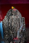 Jain idol in Dharmaraj temple
 -
 Jain idol in Dharmaraj temple
 -
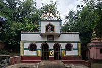 Dharmaraj temple
 -
 Bir stambha


Healthcare
Para Block Primary Health Centre, with 30 beds, at Para, is a major government medical facility in the Para CD block.[20]
References
- ^ Houlton, Sir John, Bihar, the Heart of India, 1949, p. 170, Orient Longmans Ltd.
- ^ "District Statistical Handbook 2014 Purulia". Tables 2.1, 2.2. Department of Planning and Statistics, Government of West Bengal. Retrieved 12 January 2020.
- ^ "Area wise Closed User Group (CUG) Telephone Numbers" (PDF). Sodepur Area. Eastern Coalfields Limited. Retrieved 11 August 2018.
- ^ "Santaldih Thermal Power Station - WBPDCL". WBPDCL. Retrieved 24 August 2011.
- ^ a b "Old temple at Banda (locally known as deul)". ASI, Kolkata Circle. Retrieved 23 January 2020.
- ^ "List of Ancient Monuments and Archaeological Sites and Remains of West Bengal - Archaeological Survey of India". Item no. 134. ASI. Retrieved 25 January 2020.
- ^ "Capital in shambles: Garh Panchakot, Purulia". Heritage in Peril. Retrieved 1 December 2016.
- ^ "Historical ruins". Trek Earth. Retrieved 1 December 2016.
- ^ "CD block Wise Primary Census Abstract Data(PCA)". West Bengal – District-wise CD Blocks. Registrar General and Census Commissioner, India. Retrieved 1 February 2020.
- ^ "District Census Handbook Puruliya, Census of India 2011, Series 20, Part XII A" (PDF). Section II Town Directory, Pages 1073-1083 Statement I: Status and Growth History, Pages 1006-1010; Statement II: Physical Aspects and Location of Towns, Pages 1010-1015; Statement III: Civic and other Amenities, Pages 1015-1019; Statement IV: Medical Facilities 2009, Pages 1019-1027 Statement V: Educational, Recreational and Cultural Facilities, Pages 1027- 1029: Statement VI:Industry and Banking. Directorate of Census Operations V, West Bengal. Retrieved 30 January 2020.
- ^ "58603 => 68103 Kharagpur-Gomoh MEMU". Time Table. IndiaRailInfo. Retrieved 1 February 2020.
- ^ "Sankra High School". SchoolsWorld.in. Retrieved 1 February 2020.
- ^ "Jhapra High School". SchoolsWorld.in. Retrieved 1 February 2020.
- ^ "Jainism in Bengal and Purulia". P. Mandal. Threader. Retrieved 1 February 2020.
- ^ "Rediscover Purulia's Timeless Heritage". Amitabha Gupta. Outlook Traveller, 22 August 2018. Retrieved 1 February 2020.
- ^ "List of Ancient Monuments and Archaeological Sites and Remains of West Bengal - Archaeological Survey of India". Item no. 134. ASI. Retrieved 1 February 2020.
- ^ Dutta, Rangan. "Temples of Para, Purulia". Wordpress. Retrieved 10 January 2020.
- ^ "Old temple at Banda (locally known as deul)". ASI, Kolkata Circle. Retrieved 1 February 2020.
- ^ Ananda Bazar Patrika, in Bengali, 28 December 2019, Amar Gram
- ^ "Rural Health". Purulia district administration. Retrieved 1 February 2020.
