
Pakbirra
Pakbirra | |
|---|---|
Village | |
Manbazar | |
| Website | purulia |
Pakbirra is a village in the
.Geography

5miles
Reservoir
CT: census town, R: rural/ urban centre, H: historical/ religious centre
Owing to space constraints in the small map, the actual locations in a larger map may vary slightly
Location
Pakbirra is located at 23°09′13″N 86°39′57″E / 23.1535°N 86.6658°E.
Area overview
Purulia district forms the lowest step of the Chota Nagpur Plateau. The general scenario is undulating land with scattered hills. Manbazar subdivision, shown in the map alongside, is located in the eastern part of the district. It is an overwhelmingly rural subdivision with 96.32% of the population living in the rural areas and 3.68% living in the urban areas. There are 3 census towns in the subdivision. The map shows the Kangsabati Project Reservoir. The Mukutmanipur Dam is in Bankura district but the upper portion of the reservoir is in Manbazar subdivision. The remnants of old temples and deities are found in the subdivision also, as in other parts of the district. The subdivision has a very high proportion of Scheduled Castes and Scheduled Tribes. Bandwan CD block has 51.86% ST population, Manbazar II CD block has 48.97% ST population. Manbazar I CD block has 22.03% ST and 22.44% SC. Puncha CD block has 24.74% ST and 14.54 SC.[1][2][3][4] Writing in 1911, H. Coupland, ICS, speaks of the aboriginal races largely predominating in the old Manbhum district. He particularly mentions the Kurmis, Santhals, Bhumij and Bauri.[5]
Note: The map alongside presents some of the notable locations in the subdivision. All places marked in the map are linked in the larger full screen map.
Demographics
According to the
Transport
Pakbirra is about 40 km from Purulia town.[7] A short stretch of local roads link Pakbirra to Puncha town.[8]
Pakbirra Jain temples
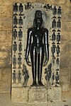
Pakbirra Jain temples are a collection of three temples. Relics here date back to the ninth and tenth centuries AD. Most impressive of sculptures present in this temple is the colossal 7.5 feet high statue Shitalnatha and 8 feet high statue of Padmaprabha carved of polished black stone. Statue of Padmaprabha is also worshipped as Bhairavnath by people of Hindus faith. The temple has many sculptures including sculptures of Tirthankar Rishabhnath, Parshvanatha, Mahavira along with Goddess Devi Ambika and Padmavati.[9]
This temple have the basic
Pakbirra picture gallery
-
 Pakbirra Jain Shrine
 -
 7.5 feet statue of Shitalanatha
 -
 4 ft. high Statue of Adinath at Pakbirra Jain Shrine, Purulia
 -
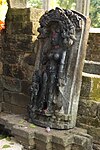
 Parshvanatha idol
 -
 Statue of Ambika at Pakbirra
 -
 Sahstra pat - a stone plate housing 356 idols of Tirthankars with Lord Adinath seated in the middle


References
- ^ Houlton, Sir John, Bihar, the Heart of India, 1949, p. 170, Orient Longmans Ltd.
- ^ "District Statistical Handbook 2014 Purulia". Tables 2.1, 2.2. Department of Planning and Statistics, Government of West Bengal. Archived from the original on 21 January 2019. Retrieved 12 January 2020.
- ^ "CD block Wise Primary Census Abstract Data(PCA)". 2011 census: West Bengal – District-wise CD blocks. Registrar General and Census Commissioner, India. Retrieved 16 January 2020.
- ^ "Travel and Tourism : Purulia". The Official Website of Purulia District.
- ^ "Bengal District Gazetteers – Manbhum by H. Coupland". Page 76: Manbhum, Castes and Tribes. University of California, San Diego. Retrieved 10 February 2020.
- ^ "C.D. Block Wise Primary Census Abstract Data(PCA)". West Bengal – District-wise CD Blocks. Registrar General and Census Commissioner, India. Retrieved 19 January 2020.
- ^ "District Census Handbook, Puruliya, Series 20, Part XII A" (PDF). Page 102:Brief Description of Places of Religious, Historical or Archaeological Importance and Places of Tourist Interest of the District. Directorate of Census Operations, West Bengal. Retrieved 19 January 2020.
- ^ Google maps
- ^ Bradshaw, George (1860), Bradshaw's hand-book to the Bengal presidency, and Western provinces of India, Oxford University, p. 221
- ^ "Travel and Tourism : Purulia". The Official Website of Purulia District.
