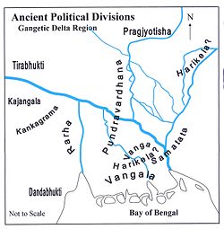
Kajangala
Source: Wikipedia, the free encyclopedia.
Ancient Territory

Kajangala (Bengali: কজঙ্গল), refers to a territory located near Rajmahal in ancient times, in eastern part of India.[1]
Extent
It was spread across what is now part of
History
The
References
- ISBN 81-89118-01-3.
- ISBN 81-7079-270-3
- ^ Majumdar, Dr. R.C., p. 454
Birbhum district topics | |||||||
|---|---|---|---|---|---|---|---|
| General |
| ||||||
| People |
| ||||||
| Subdivisions | |||||||
| Territories | |||||||
| Municipalities | |||||||
Community development blocks |
| ||||||
| Higher Education |
| ||||||
| Rivers | |||||||
| Transport | |||||||
| Railway stations | |||||||
| Lok Sabha constituencies |
| ||||||
| Vidhan Sabha constituencies | |||||||
| Former Vidhan Sabha constituencies | |||||||
| See also | |||||||
Santhal Pargana division topics | |||||||||||||
|---|---|---|---|---|---|---|---|---|---|---|---|---|---|
| General |
| ||||||||||||
| Districts | |||||||||||||
| Subdivisions | |||||||||||||
Community development blocks |
| ||||||||||||
| Rivers, waterfalls, dams | |||||||||||||
| Languages, people | |||||||||||||
| Transport |
| ||||||||||||
| Railway stations | |||||||||||||
| History |
| ||||||||||||
| Institutes of higher learning |
| ||||||||||||
| Lok Sabha constituencies |
| ||||||||||||
| Vidhan Sabha constituencies |
| ||||||||||||
| See also | |||||||||||||
| Other Divisions | |||||||||||||
25°02′56″N 87°50′17″E / 25.0489°N 87.83803°E / 25.0489; 87.83803
This Indian history-related article is a stub. You can help Wikipedia by expanding it. |
