Ladakh Range
| Ladakh Range | |
|---|---|
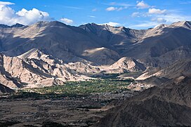
 View of Ladakh Range above Leh | |
| Dimensions | |
| Length | 370 km (230 mi) |
| Geography | |
| Country | Kailash Range |
The Ladakh Range is a mountain range in central Ladakh in India with its northern tip extending into Baltistan in Pakistan. It lies between the Indus and Shyok river valleys, stretching to 230 miles (370 km).[1] Leh, the capital city of Ladakh, is on the foot of Ladakh Range in the Indus river valley.
Geography
The Ladakh Range is regarded as a southern extension of the
The Ladakh Range forms the northeastern bank of the Indus River and the western bank of the Shyok River.[4]
The Ladakh Range has an average height of about 6,000 metres and has no major peaks. Some of its peaks are less than 4,800 metres.[5]
The main mountain passes are
Habitation
The city of
Leh was for centuries trade centre for fine
Two English explorers, William Moorcroft and George Trebeck visiting Leh in 1820, were stunned seeing a town of such wealth located in midst of obviously arid desert land.
The nomadic Changpa rely mostly on sheep and yak herding for subsistence in the Ladakh Range. Tibet's Chang Tang plain, most remote section of Himalayas, is extreme high country; here the valleys are about 14,000 feet above sea level.
Ladakh is a desert region. Culturally/geographically close to Tibet, it has few resources with an extreme climate. The
The extension of the Ladakh Range into China is known as
References
- ^ a b c Negi, Discovering the Himalaya, Volume 1 1998, p. 14.
- ^ Ladakh Range, Encyclopedia Britannica, retrieved 22 April 2018.
- ^ Mehra, An "agreed" frontier 1992, end papers.
- ^ Mehra, An "agreed" frontier 1992, p. 15.
- ^ Kaul, Rediscovery of Ladakh 1998, p. 17.
- ^ Warikoo, India's gateway to Central Asia 2009, p. 1.
- ^ Warikoo, India's gateway to Central Asia 2009, p. 4.
Bibliography
- Karim, Afsir (2009), "Strategic dimensions of the trans-Himalayan frontiers", in K. Warikoo (ed.), Himalayan Frontiers of India: Historical, Geo-Political and Strategic Perspectives, Routledge, pp. 56–66, ISBN 978-1-134-03294-5
- Kaul, H. N. (1998), Rediscovery of Ladakh, Indus Publishing, ISBN 978-81-7387-086-6
- Mehra, Parshotam (1992), An "agreed" frontier: Ladakh and India's northernmost borders, 1846-1947, Oxford University Press, ISBN 978-0-19-562758-9
- Negi, S. S. (1998), Discovering the Himalaya, Volume 1, Indus Publishing, ISBN 978-81-7387-079-8
- Warikoo, K. (2009), "India's gateway to Central Asia: trans-Himalayan trade and cultural movements through Kashmir and Ladakh, 1846–1947", in K. Warikoo (ed.), Himalayan Frontiers of India: Historical, Geo-Political and Strategic Perspectives, Routledge, pp. 1–13, ISBN 978-1-134-03294-5
External links
- Romesh Bhattacharji, Maps of Ladakh: Changing yet Unchanged, via Bame Duniya blogspot, 19 March 2013

