Land use

Land use involves the management and modification of natural environment or wilderness into built environment such as settlements and semi-natural habitats such as arable fields, pastures, and managed woods. Land use by humans has a long history, first emerging more than 10,000 years ago.[1][2] It has been defined as "the purposes and activities through which people interact with land and terrestrial ecosystems"[3] and as "the total of arrangements, activities, and inputs that people undertake in a certain land type."[4] Land use is one of the most important drivers of global environmental change.[3][5]
History
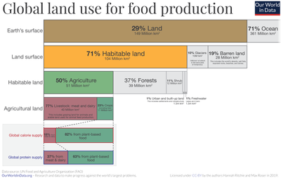
Human tribes since prehistory have segregated land into territories to control the use of land. Today, the total arable land is 10.7% of the land surface, with 1.3% being permanent cropland.[6][7]
Regulation

Land use practices vary considerably across the world. The United Nations' Food and Agriculture Organization Water Development Division explains that "Land use concerns the products and/or benefits obtained from use of the land as well as the land management actions (activities) carried out by humans to produce those products and benefits."[8] As of the early 1990s, about 13% of the Earth was considered arable land, with 26% in pasture, 32% forests and woodland, and 1.5% urban areas. Land change modeling can be used to predict and assess future shifts in land use.
As Albert Guttenberg (1959) wrote many years ago, "'Land use' is a key term in the language of
United States
In colonial America, few regulations were originally put into place regarding the usage of land. As society shifted from rural to urban, public land regulation became important, especially to city governments trying to control industry, commerce, and housing within their boundaries. The first zoning ordinance was passed in New York City in 1916,[10][11] and, by the 1930s, most states had adopted zoning laws. In the 1970s, concerns about the environment and historic preservation led to further regulation.
Today, federal, state, and local governments regulate growth and
Two major federal laws passed in the 1960s limit the use of land significantly. These are the
The
| Use | acreage (M) | km2 (M) | % of total |
|---|---|---|---|
| Pasture/range | 654 | 2.647 | 35 |
| Forest | 538.6 | 2.18 | 28 |
| Cropland | 391.5 | 1.584 | 21 |
| Special use* | 168.8 | 0.683 | 9 |
| Miscellaneous* | 68.9 | 0.279 | 4 |
| Urban | 69.4 | 0.281 | 4 |
| Total** | 1,891 | 7.653 | 100 |
- Special use areas include national parks (29 M acres) and state parks (15 M), wildlife areas (64.4 M), highways (21 M), railroads (3M), military bases (25 M), airports (3M) and a few others. Miscellaneous includes cemeteries, golf courses, marshes, deserts, and other areas of "low economic value". ** The total land area of the US is 9.1 M km2 but the total used here refers only to the contiguous 48 states, without Alaska etc.
Urban growth boundary
The urban growth boundary is one form of land-use regulation. For example, Portland, Oregon is required to have an urban growth boundary which contains at least 20,000 acres (81 km2) of vacant land. Additionally, Oregon restricts the development of farmland. The regulations are controversial, but an economic analysis concluded that farmland appreciated similarly to the other land.[14]
Environment
| Categories | Contribution of farmed animal product [%] |
|---|---|
| Calories | 18
|
| Proteins | 37
|
| Land use | 83
|
| Greenhouse gases | 58
|
| Water pollution | 57
|
| Air pollution | 56
|
| Freshwater withdrawals | 33
|
| Food Types | Land Use (m2year per 100g protein) |
|---|---|
| Lamb and Mutton | 185
|
| Beef | 164
|
| Cheese | 41
|
| Pork | 11
|
| Poultry | 7.1
|
Eggs
|
5.7
|
| Farmed Fish | 3.7
|
| Groundnuts | 3.5
|
Peas
|
3.4
|
| Tofu | 2.2
|
Land use and
The major effect of land use on
According to a report by the
Land use change

See also
- Agricultural district
- Building setback– Step-like recession in a wall
- Cultural landscape – Landscape, which is permanently embossed by humans
- Land Allocation Decision Support System
- Land Use Evolution and Impact Assessment Model
- Land-use forecasting – Projecting the distribution and intensity of trip generating activities in the urban area
- Indirect land use change impacts of biofuels – Negative spillover effect of production of biofuels
- Land change modeling – Geographic and ecological field of study
- Land-use planning – Process of regulating the use of land by a central authority
- Land-use conflict – disagreement about what a particular area of land should be used for
- Variance (land use) – administrative exception to land use regulations
References
- S2CID 201674203.
- PMID 33875599.
- ^ S2CID 158366220.
- ^ "Land Use, Land-Use Change and Forestry". www.grida.no. Archived from the original on December 6, 2017. Retrieved September 29, 2022.
- S2CID 244592514.
- ^ "World Bank arable land". World Bank. Archived from the original on October 2, 2015. Retrieved October 19, 2015.
- ^ "World Bank permanent cropland". World Bank. Archived from the original on July 13, 2015. Retrieved October 19, 2015.
- ^ FAO Land and Water Division retrieved 14 September 2010
- ^ JAPA 25:3
- Village of Euclid, Ohio v. Ambler Realty Co.
- New York State Bar Journal: 38.
- S2CID 213239635.
- ^ a b Merrill, Dave; Leatherby, Lauren (July 31, 2018). "Here's How America Uses Its Land". Bloomberg. Retrieved 2018-08-05.
- ^ Jaeker WG, Plantinga AJ (2007). How have Land-use regulations Affected Property Values in Oregon? Archived 2012-07-22 at the Wayback Machine OSU Extension.
- ^ Carrington, Damian (31 May 2018). "Avoiding meat and dairy is 'single biggest way' to reduce your impact on Earth". The Guardian. Retrieved 19 August 2018.
- PMID 29853680.
- hdl:10459.1/65151. Archived(PDF) from the original on August 9, 2021. Retrieved September 8, 2022.
- ISBN 978-92-95110-48-9. Archived(PDF) from the original on September 20, 2022. Retrieved September 18, 2022.
- ISBN 9781603580502 – via Google Books.
Forest gardening, in the sense of finding uses for and attempting to control the growth of wild plants, is undoubtedly the oldest form of land use in the world.
- ^ "Changes in Atmospheric Constituents and in Radiative Forcing" (PDF). Intergovernmental Panel on Climate Change. Archived from the original (PDF) on December 15, 2007.
- ^ UN Land Degradation and Land Use/Cover Data Sources ret. 26 June 2007
- ^ "UN Report on Climate Change" (PDF). Archived from the original (PDF) on February 3, 2007. Retrieved June 25, 2007.
- ^ "Land Change Science Program - Science". www.usgs.gov. Archived from the original on 2021-02-10. Retrieved 2021-02-09.
External links
- Land-use and land-cover change defined at Encyclopedia of Earth
- Land Use Law News Alert
- Land Use Law by Prof. Daniel R. Mandelker (Washington University in St. Louis School of Law)
- The Relationship Between Land Use Decisions and the Impacts on Our Water and Natural Resources
- Land Use Accountability Project The Center for Public Integrity
- Schindler's Land Use Page (Michigan State University Extension Land Use Team)
- Land Policy Institute at Michigan State University
- Land Use, Cornell University Law School
