
Mandalay Hill
| Mandalay Hill | |
|---|---|
List of mountains in Burma | |
| Coordinates | 22°0′51″N 96°6′27″E / 22.01417°N 96.10750°E[1] |
| Naming | |
| Native name | မန္တလေးတောင် (Burmese) |
| Geography | |
 Mandalay Hill Location in Burma | |
| Location | Aungmyethazan Township, Mandalay, Myanmar |
| Climbing | |
| First ascent | unknown |
| Easiest route | escalator |
Mandalay Hill (
Climbing Mandalay Hill


Buddhists consider climbing the hill a rewarding experience and a meritorious deed for those able to do so. Two statues of
Farther up, halfway to the summit,
The last stop before the Sutaungpyei pagoda completes the legend of Mandalay. Here on the south terrace of a small
At the summit

Once on the terrace of the Sutaungpyei Pagoda, a panoramic view of the Mandalay plain stretches far to the horizon, with the old city walls and moat, the Thudhamma
World War II

In March 1945, the
The Japanese stood firm and the last defenders had to be blown out from the cellars by rolling down petrol drums and igniting them with tracer bullets. It was not until 11 March that the hill fell into British hands. Aerial bombardment was resorted to when shelling from the hill failed to breach the city wall and destroy the enemy, and Mandalay Palace, a national heritage of great importance, burnt down during the siege. Whether it was the shelling and bombing or the enemy that destroyed the splendid teak palace was never determined with any certainty.[4]
Gallery
-
 Two giant chinthes guard the southern approach to Mandalay Hill
 -
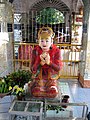 Sanda Muhki, the ogress, offering her own breasts to the Buddha
 -
 Mandalay Hill from East Moat Bridge
 -
 Crown Prince Ka Naunglies buried
 -
 Up the saungdan at Mandalay Hill
 -
 The lizard is one of many former incarnations of the Buddha
 -
-
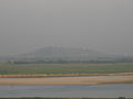
 TheShan Yomaeast of Mandalay Hill
 -
 View from the west, on theRiver Irrawaddy
 -
 View from the east,MaymyoRoad
 -
 View from the north, Madaya Road
 -
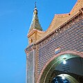 Detail of part of the Sutaungpyai Temple
 -
 View from Mandalay Hill


See also
- Sandamuni Pagoda
- Kuthodaw Pagoda
- Tripiṭaka tablets at Kuthodaw Pagoda
- List of mountains in Burma
References
- ^ GoogleEarth
- ^ Ludu Daw Amar (1994). Kyama do nge nge ga - "When We Were Young" in Burmese. Mandalay: Kyipwa Yay Press. pp. 44–45.
- ^ "The Shweyettaw Buddha is halfway up Mandalay Hill". Retrieved 3 January 2023.
- ^ a b Sir William Slim (1956). Defeat into Victory. Great Britain: Pan Books 1999. pp. 390, 468, 470.