
Pacific Northwest
Pacific Northwest Cascadia | |
|---|---|
  .jpg)   .jpg)  Left-right from top: | |
| Largest metropolitan areas | |
| Dialect | Pacific Northwest English |

The Pacific Northwest (PNW), sometimes referred to as Cascadia, is a geographic region in western
The Northwest Coast is the coastal region of the Pacific Northwest, and the Northwest Plateau (also commonly known as "the Interior" in British Columbia),[1] is the inland region. The term "Pacific Northwest" should not be confused with the Northwest Territory (also known as the Great Northwest, a historical term in the United States) or the Northwest Territories of Canada. The region is sometimes referred to as Cascadia, which, depending on the borders, may or may not be the same thing as the Pacific Northwest.
The region's largest metropolitan areas are
The culture of the Pacific Northwest is influenced by the Canada–United States border, which the United States and the United Kingdom established at a time when the region's inhabitants were composed mostly of indigenous peoples. Two sections of the border—one along the 49th parallel south of British Columbia and one between the Alaska Panhandle and northern British Columbia—have left a great impact on the region. According to Canadian historian Ken Coates, the border has not merely influenced the Pacific Northwest—rather, "the region's history and character have been determined by the boundary".[5]
Definition

Definitions of the "Pacific Northwest" region vary, and even Pacific Northwesterners do not agree on the exact boundary.[7][8] The most common conception includes the U.S. states of Oregon, Washington, Idaho, and sometimes the Canadian province of British Columbia.[5]
Broader definitions of the region have included the U.S. states of Alaska and parts of the states of California, Montana, and Wyoming, and the Canadian territory of Yukon.[5][9][10]
Definitions based on the historic Oregon Country reach east to the Continental Divide, thus including all of western Montana and western Wyoming. Sometimes, the Pacific Northwest is defined as being the Northwestern United States specifically, excluding Canada.
History
Indigenous peoples
The Pacific Northwest has been occupied by a diverse array of
The coastal migration hypothesis has been bolstered by findings such as the report that the sediments in the Port Eliza Cave
Due in part to the richness of Pacific Northwest Coast and river fisheries, some of the indigenous peoples developed complex sedentary societies, while remaining hunter-gatherers.[18] The Pacific Northwest Coast is one of the few places where politically complex hunter-gatherers evolved and survived to historic contacts, and therefore has been vital for anthropologists and archaeologists seeking to understand how complex hunter and gatherer societies function.[19] When Europeans first arrived on the Northwest Coast, they found one of the world's most complex hunting and fishing societies, with large sedentary villages, large houses, systems of social rank and prestige, extensive trade networks, and many other factors more commonly associated with societies based on domesticated agriculture.[19][20] In the interior of the Pacific Northwest, the indigenous peoples, at the time of European contact, had a diversity of cultures and societies. Some areas were home to mobile and egalitarian societies. Others, especially along major rivers such as the Columbia and Fraser, had very complex, affluent, sedentary societies rivaling those of the coast.[21]
In British Columbia and Southeast Alaska, the Haida and Tlingit erected large and elaborately carved totem poles that have become iconic of Pacific Northwest artistic traditions. Throughout the Pacific Northwest, thousands of indigenous people live, and some continue to practice their rich cultural traditions, "organizing their societies around cedar and salmon".[22]
Initial European exploration
In 1579, the British captain and erstwhile
In 1774, the viceroy of
In 1779, a third Spanish expedition, under the command of

From 1792 to 1794, George Vancouver charted the Pacific Northwest on behalf of Great Britain, including the Strait of Georgia, the bays and inlets of Puget Sound, and the Johnstone Strait–Queen Charlotte Strait and much of the rest of the British Columbia Coast and southeast Alaska shorelines.[32] For him the city of Vancouver and Vancouver Island are named, as well as Vancouver, Washington. From Mexico, Malaspina dispatched the last Spanish exploration expedition in the Pacific Northwest, under Dionisio Alcalá Galiano and Cayentano Valdes aboard the schooners Sutil and Mexicana.[34] They met Vancouver in the Strait of Georgia on June 21, 1792. Vancouver had explored Puget Sound just previously. The Spanish explorers knew of Admiralty Inlet and the unexplored region to the south, but they decided to sail north. They discovered and entered the Fraser River shortly before meeting Vancouver. After sharing maps and agreeing to cooperate, Galiano, Valdés, and Vancouver sailed north to Desolation Sound and the Discovery Islands, charting the coastline together. They passed through Johnstone Strait and Cordero Channel and returned to Nootka Sound. As a result, the Spanish explorers, who had set out from Nootka, became the first Europeans to circumnavigate Vancouver Island. Vancouver himself had entered the Strait of Juan de Fuca directly without going to Nootka first, so had not sailed completely around the island.[33]
In 1786,
Continental crossover exploration
Explorer Alexander Mackenzie completed in 1793 the first continental crossing in what is called today central British Columbia and reached the Pacific Ocean. Simon Fraser explored and mapped the Fraser River from Central British Columbia down to its mouth in 1808. And mapmaker David Thompson explored in 1811 the entire route of the Columbia River from its northern headwaters all the way to its mouth. These explorations were commissioned by the North West Company and were all undertaken with small teams of Voyageurs.
United States President
These early land expeditions mapped the way for subsequent land explorations and building early settlements.
Subsequent land explorations
The Willamette River was the first PNW inland waterway to be explored north–south during trapping expeditions carried out throughout the 1810s by the Pacific Fur Company soon acquired by the North West Company (NWC). During the 1820s, the upper Willamette, the Umpqua, the Rogue, the Klamath were all reached still heading southward up toward the Sacramento River and California under the Hudson's Bay Company (HBC) having now itself acquired the NWC. The Siskiyou Trail was gradually being established by Alexander Roderick McLeod and Peter Skene Ogden leading related expeditions for the HBC.
Also during the 1820s, HBC explorations were carried out northward originating from the Columbia River Fort Astoria long renamed to Fort George. Simon Plamondon first ventured during the early 20s into the Cowlitz River up to Cowlitz Prairie. By 1824, an expedition led by James McMillan was reaching Puget Sound via the Chehalis River (Washington) and a portage. The same expedition went on all the way to Boundary Bay and reached the Fraser River via the Nicomekl and the Salmon linked via a portage. The lower Fraser was revisited 16 years after explorer Simon Fraser (NWC) had first reached its mouth, although originating from northern present-day British Columbia. Puget Sound soon after would get reached via the Cowlitz and the Cowlitz Landing portage, but originating from new HBC headquarter Fort Vancouver located closer by, North of the Columbia.
Early settlements

Noteworthy Russian settlements still in place include:
Other early occupation non-Indigenous settlements of interest, either long lasting or still in place, built and operated by either the
Also of interest are the first mixed ancestry settlements sometimes referred as Métis settlements or French Canadian settlements. Native and newly arrived "half-breeds" (born out of "Europeans" and Indigenous alliances), local and newly arrived Indigenous people as well as "French Canadians" all issued of the fur trade were all able to peacefully coexist. Small scale farming occurred. Catholic missions and churches thrived for many years. These first settlements were: French Prairie, Frenchtown near Walla Walla, Cowlitz Prairie (Washington), French Settlement (Oregon) and Frenchtown near Missoula. Most mixed ancestry people ended up resettled in or around Indigenous reserves during the subsequent period, or otherwise assimilating in the mainstream.[36]
Boundary disputes

Initial formal claims to the region were asserted by Spain in 1513 with explorer
The United States established a claim based on the discoveries of Robert Gray, the Lewis and Clark Expedition, the construction of Fort Astoria, and the acquisition of Spanish claims given to the United States in the Adams–Onís Treaty.[37] From the 1810s until the 1840s, modern-day Washington, Oregon, Idaho, and western Montana, along with most of British Columbia, were part of what the United States called the Oregon Country and Britain called the Columbia District. This region was jointly claimed by the United States and Great Britain after the Treaty of 1818, which established a co-dominion of interests in the region in lieu of a settlement. In 1840, American Charles Wilkes explored in the area. John McLoughlin, Chief Factor of the Hudson's Bay Company, headquartered at Fort Vancouver, was the de facto local political authority for most of this time.
This arrangement ended as U.S. settlement grew and President
The mainland territory north of the 49th parallel remained unincorporated until 1858, when a mass influx of Americans and others during the Fraser Canyon Gold Rush forced the hand of Colony of Vancouver Island's Governor James Douglas, who declared the mainland a Crown colony. The two colonies were amalgamated in 1866 to cut costs, and joined the Dominion of Canada in 1871. The U.S. portion became the Oregon Territory in 1848. It was later subdivided into Oregon Territory and Washington Territory. These territories became the states of Oregon, Idaho, Washington and parts of other Western states.
During the American Civil War, British Columbia officials pushed for London to invade and conquer the Washington Territory in effort to take advantage of Americans being distracted in the war on the Eastern region. This was rejected, as the UK did not wish to risk war with the United States, whose forces were better prepared and trained much more than the British troops.[39]
American expansionist pressure on British Columbia persisted after the colony became a province of Canada, even though Americans living in the province did not harbor
Geology
The Northwest is still highly geologically active, with both active volcanoes and geologic faults.[41]
The last known great earthquake in the northwest was the 1700 Cascadia earthquake.[42] The geological record reveals that "great earthquakes" (those with moment magnitude 8 or higher) occur in the Cascadia subduction zone about every 500 years on average, often accompanied by tsunamis. There is evidence of at least 13 events at intervals from about 300 to 900 years.[43]
Active volcanoes in the region include Mount Garibaldi, Mount Baker, Mount Rainier, Mount St. Helens, Mount Adams, Mount Hood, Mount Meager, Mount Jefferson, Mount Shasta, Lassen Peak and Glacier Peak.
Geography

.jpg)
The Pacific Northwest is a diverse geographic region, dominated by several mountain ranges, including the
The Columbia River cuts a deep and wide gorge around the rim of the Columbia Plateau and through the Cascade Range on its way to the Pacific Ocean.Because many areas have plentiful rainfall and mild summers, the Pacific Northwest has some of North America's most lush and extensive forests, which are extensively populated with
Coastal features are defined by the interaction with the Pacific and the North American continent. The coastline of the Pacific Northwest is dotted by numerous fjords, bays, islands, and mountains. Some of these features include the Oregon Coast, Burrard Inlet, Puget Sound, and the highly complex fjords of the British Columbia Coast and Southeast Alaska. The region has one of the world's longest fjord coastlines.[45]
The Pacific Northwest contains an uncountable number of islands, many of the smaller ones being unnamed. The vast majority of such islands are in British Columbia and Alaska. Vancouver Island is by far the largest island in the area, but other significant land masses include the Haida Gwaii, vast and remote Princess Royal Island, Prince of Wales Island and Chichagof Island. The Salish Sea located close to major populated areas contains smaller but more frequently visited and well known islands. These include Whidbey Island, Salt Spring Island, and Texada Island, along with dozens of smaller islands in the San Juan and Gulf Island chains.
The major cities of Vancouver,
If defined as British Columbia, Idaho, Oregon and Washington, the Pacific Northwest has four
Other outstanding natural features include the
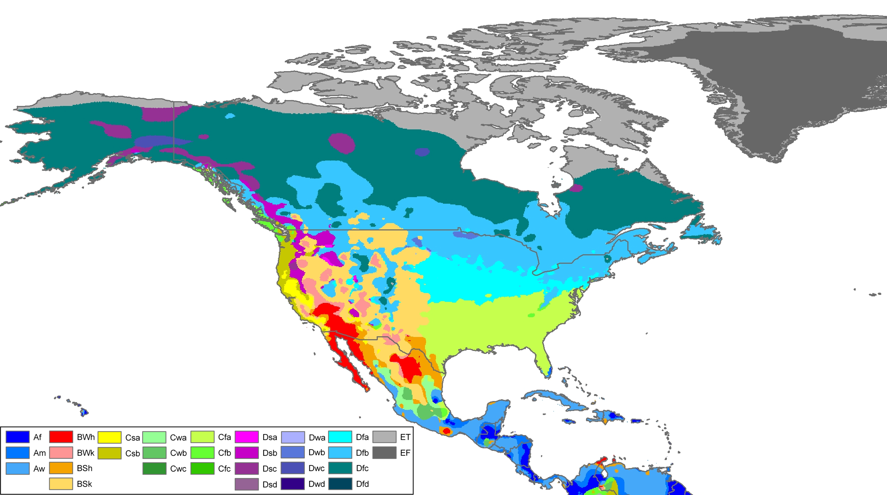
Climate
The main general climatic types of the Pacific Northwest are temperate; cool temperatures and frequent cloudy skies are typical. Under the
The lack of rain in the hot season is associated with high atmospheric pressure. The shadows of the mountains also greatly decrease the amount of precipitation. West of the Cascades, the marine climates have a much greater precipitation than the west coast of Europe due to orographic lift, with some regions seeing as much as 3,500 mm (138 in) of precipitation per year. Winters are very mild for the region's latitude. The growth of Arbutus, an evergreen broad-leafed tree, is possible on Vancouver Island due to the mild winters.[49][50][51][52][53][54]
The Big Dark
The Big Dark is a term for winter in the Pacific Northwest. At a latitude of almost 48 degrees north, Seattle has sunsets before 6 PM between October and March, and fewer than eight hours of daylight for many weeks around the winter solstice.[55][56] The darkness contributes to seasonal affective disorder among people living in northern cities, including those in the Puget Sound region.[57][58][59] The darkness is enhanced by a return from dry summers to extremely cloudy and wet weather characterized by recurring atmospheric rivers and Pacific Northwest windstorms.[55][60]
Ecoregions

Much of the Pacific Northwest is forested. The
Demographics
Population

The overwhelming majority of the population of the Pacific Northwest is concentrated in the Portland–Seattle–Vancouver corridor. As of 2016, the combined populations of the
List of largest cities by population in the Pacific Northwest
| City | State/Province | Population | Metropolitan area | Urban area |
|---|---|---|---|---|
| Seattle | Washington | 704,000[67] | 3,905,026[68] | 3,059,393[69] |
| Portland | Oregon | 658,347[68] | 2,753,168[68] | 1,849,898[69] |
| Vancouver | British Columbia | 631,486[70] | 2,737,698[3] | 2,264,823[71] |
| Surrey | British Columbia | 598,530[70] | [a] | [a] |
| Burnaby | British Columbia | 257,926[70] | [a] | [a] |
| Boise | Idaho | 236,634[72] | 691,423[68] | 349,684[69] |
| Spokane | Washington | 222,081[67] | 573,493 [73][74] | 486,225[69] |
| Richmond | British Columbia | 216,046[70] | [a] | [a] |
| Tacoma | Washington | 198,397[67] | [b] | [b] |
| Vancouver | Washington | 175,673[67] | [c] | [c] |
| Salem | Oregon | 169,798[75] | 390,738[68] | 236,632[69] |
| Eugene | Oregon | 168,916[75] | 351,715[68] | 247,421[69] |
| Abbotsford | British Columbia | 161,581[70] | 204,265[3] | 121,279[71] |
| Coquitlam | British Columbia | 152,734[70] | [a] | [a] |
| Bellevue | Washington | 148,164[76] | [b] | [b] |
| Kelowna | British Columbia | 146,127[70] | 222,748[3] | 151,957[71] |
| Redmond | Washington | 136,420[76] | [b] | [b] |
| Langley (Township) | British Columbia | 133,302[70] | [a] | [a] |
| Kent | Washington | 125,560[67] | [b] | [b] |
| Saanich | British Columbia | 125,107[70] | [d] | [d] |
| Delta | British Columbia | 111,281[70] | [a] | [a] |
| Gresham | Oregon | 111,063[75] | [c] | [c] |
| Hillsboro | Oregon | 106,894[75] | [c] | [c] |
| Meridian | Idaho | 106,000[77] | [e] | [e] |
| Everett | Washington | 103,019[67] | [b] | [b] |
| Nanaimo | British Columbia | 101,336[70] | 117,144[3] | 88,799[71] |
| Kamloops | British Columbia | 101,198[70] | 116,896[3] | 78,026[71] |
| Beaverton | Oregon | 97,514[75] | [c] | [c] |
| Renton | Washington | 95,448[67] | [b] | [b] |
| Spokane Valley | Washington | 94,919[67] | [f] | [f] |
| Chilliwack | British Columbia | 95,178[70] | 116,626[3] | 73,161[71] |
| Bend | Oregon | 94,520[78] | 170,705 | 83,794[69] |
| Victoria | British Columbia | 94,415[70] | 408,883[3] | 335,696[71] |
| Nampa | Idaho | 93,590[79] | [e] | [e] |
| Kirkland | Washington | 93,010[76] | [b] | [b] |
| Maple Ridge | British Columbia | 91,479[70] | [a] | [a] |
| Bellingham | Washington | 92,314[67] | 201,140[80] | 114,473[69] |
| Yakima | Washington | 91,067[81] | 243,231[81] | 129,534[69] |
North Vancouver (District) |
British Columbia | 89,767[70] | [a] | [a] |
| Federal Way | Washington | 89,306[67] | [b] | [b] |
| Kennewick | Washington | 84,347[76] | 268,200 | 232,954[69] |
| New Westminster | British Columbia | 82,590[70] | [a] | [a] |
| Prince George | British Columbia | 82,290[70] | 96,015[3] | 65,510[71] |
| Missoula | Montana | 76,784 | 117,922 | |
| Medford | Oregon | 74,907[78] | 207,010 | 154,081[69] |
Ethnicity
This section needs additional citations for verification. (June 2022) |
In British Columbia,
In the U.S. side of the region, Latinos make up a large portion of the agricultural labor force east of the Cascade Range, and are an increasing presence in the general labor force west of the Cascades. Despite the Second Great Migration from the 1940s to 1960s due to the booming Boeing war industry and post-war growing economy, African Americans are less numerous in the Pacific Northwest; however, the overall African American population has been growing in other smaller urban areas throughout the region such as Eugene.[84] African Americans tend to concentrate in western urban areas such as Tacoma, south Seattle, and Portland. Nonetheless, Black people have a very large presence in Tacoma's Hilltop and South Tacoma neighborhoods, Seattle's Central District and Rainier Valley neighborhoods,[85] and in Portland's Northeast Quadrant.[86] There are growing numbers in Vancouver as well, particularly Africans, Jamaicans and Black people from the United States.
Beginning in the late 20th century, a general
African Americans have held the positions of Mayor in Seattle; King County executive, while the state of Washington elected a
British Columbians of many ethnicities are prominent in all levels of politics and government, and the province has a number of "firsts" in Canadian political history, including the first non-white and Asian
Oregon has been a national leader concerning
Language
Most Americans and Canadians consider the
French was the
Besides English and indigenous languages,
Spirituality and religion
| Religion | British Columbia (2021)[92] | Washington (2014 est.)[93]
|
Oregon (2014 est.)[94]
|
Idaho (2014 est.)[95]
| ||||
|---|---|---|---|---|---|---|---|---|
| Affiliation | % of population | |||||||
Christian
|
34 | 61 | 61 | 67 | ||||
Protestant
|
10 | 40 | 43 | 37 | ||||
Catholic
|
12 | 17 | 12 | 10 | ||||
Mormon
|
<1 | 3 | 4 | 19 | ||||
| Jehovah's Witnesses | 1 | 2 | <1 | <1 | ||||
| Orthodox | 1 | <1 | 1 | 1 | ||||
| Other Christian/Not Specified | 11 | 1 | 1 | <1 | ||||
Unaffiliated
|
52 | 33 | 32 | 28 | ||||
| Non-Christian | 14 | 6 | 7 | 4 | ||||
Sikh
|
6 | <1 | <1 | <1 | ||||
Muslim
|
3 | <1 | 1 | 1 | ||||
Buddhist
|
2 | 1 | <1 | <1 | ||||
Hindu
|
2 | 1 | <1 | <1 | ||||
Jewish
|
1 | 1 | 2 | <1 | ||||
| Other faith | 1 | 3 | 4 | 2 | ||||
| Total | ||||||||
The Pacific Northwest has the lowest rate of church attendance in the United States and consistently reports the highest percentage of
Religion plays a smaller part in Pacific Northwest politics than in the rest of the United States. The
That said, three of the four major international
The region is also known as a magnet for a wide range of philosophical and spiritual belief systems. Eastern spiritual beliefs have been adopted by an unusually large number of people (by North American standards), and Tibetan Buddhism in particular has a strong local following.[102] The Northwest Tibetan Cultural Association, claimed to be the largest organization of its kind in the world, was founded in Portland in 1993.
The region is home to many unique Christian communities, ranging from the
Yogic teachings, Sufism, tribal and ancient beliefs and other philosophies are widely studied and appreciated in the region. The
Also in Vancouver, there is a small
Two of the five
Some people in the area also embrace alternative
- Brother Twelve ran a controversial commune in the Gulf Islands of British Columbia early in the 20th century.[109]
- The Emissaries of Divine Light are a notable presence in the region of 100 Mile House, British Columbia and also have a large ashram on Kootenay Lake, northeast of Nelson, British Columbia.[110]
- The followers of the Guru sannyasins, established a center for their beliefs and lifestyle near Antelope, Oregon, which included an ashram complex as well as, for a while, an attempted takeover of the local economy.[111]
- The training school of the immortal (according to the organization) being Ramtha is headquartered in Yelm, Washington.[112]
- Eckhart Tolle, author of The Power of Now, lives in Vancouver, British Columbia.[113]
- Neale Donald Walsch, author of Conversations with God, lives in Ashland, Oregon, where he runs a retreat center.[114]
Politics
A major divide in political opinion separates the region's greatly more populated urban core and rural areas west of the mountains from its less populated rural areas to their east and (in British Columbia and Alaska) north.
The jurisdictions have relatively liberal
These areas, especially around Puget Sound, have a long history of political radicalism. The radical labor organizers called
Due to the Pacific Northwest being a generally liberal region, it also has a long history of feminism and people with feminist ideologies. The journey on the Oregon Trail may have been the part of the cause of feminism in the region, many women on the trail had to break gender-normative roles.[119] Women occasionally were allowed the chance to try new things like cracking the whip for the wagon, given these opportunities women began to question their roles in society.[119] Early days in the west, no forms of government had been established and this may have been part of the cause of feminist ideologies, new laws were formed to fit the regions needs and women were granted rights to land ownership in the West much earlier than in the East because of high death rates of men in the region.[120] While this may be coincidental, this granted women power. Women's suffrage movements were prominent in the Pacific Northwest; Susan B. Anthony did a tour through the region attempting to spread her ideas and made stops in Portland, the Willamette Valley, Columbia River, and Victoria.[121] Not only were women's suffrage movements prominent in the Pacific Northwest, but there was also a fight for women to keep their jobs after men returned from war in World War I.[122] A group titled the Washington State Women's Council (founded in 1963) fought for women's policies, this group worked towards the states' equal rights amendment, and fought for women's property rights in marriage during the 1972 legislative session.[123]
The region also has a long history of starting cooperative and communal businesses and organizations, including
East of the Cascades, in Eastern Washington and Eastern Oregon, the population is much more conservative. The eastern portions of Washington and especially Oregon, due to their low populations, do not generally have enough voting power to be competitive at the state level, and thus the governorships and U.S. Senate seats of both Oregon and Washington are usually held by the Democrats. Conservatism in the eastern part of the Pacific Northwest tends to be distrustful of federal government interference in the market.
Economy
- Agriculture (fruit, )
- Aerospace (Precision Castparts Corporation)
- Diversified (Washington Marine Group)
- Entertainment industry (film and television, Bridge Studios)
- Finance and banking (RBC, HSBC Bank Canada, Russell Investments, Umpqua Holdings Corporation)
- Forestry (Green Diamond Resource Company)
- Fishing and canning (salmon, halibut, herring, geoducks and other clams, crab, sea-urchin, oyster)
- )
- Hydroelectric power (Grand Coulee Dam, Bonneville Dam, BC Hydro)
- Mass Retail ()
- )
- Mining (Goldcorp, Teck Resources)
- Outdoor Tourism (water sports)
- Shoes and apparel (Nike, Nordstrom, Adidas North America, Brooks Sports, Columbia, REI, Lululemon Athletica, Eddie Bauer, Mountain Equipment Co-op)
- Real estate marketing and construction (Zillow)
The region as a whole, but especially several specific areas, are concentrated high-tech areas: Seattle eastern suburbs, the Portland Silicon Forest area, and Vancouver, British Columbia. These areas are also leading "creative class" economic drivers, feeding thriving cultural sectors, and include many knowledge workers and numerous international advertising, media, and design firms.
Education
Colleges and universities in the Pacific Northwest:
- British Columbia
- List of colleges in British Columbia
- List of universities in British Columbia
- California (Northwestern area only, which is part of Cascadia)
- College of the Redwoods – a public two-year community college, main campus in Eureka, California.
- College of the Siskiyous – a public two-year community college, in Weed and Yreka, California.
- Humboldt State University – a California State University (public), in Arcata, California.
- Idaho
- Montana
- University of Montana
- Montana State University System
- Oregon
- Washington
Culture
.jpg)
Although the dominant culture in the Pacific Northwest today is
Environmentalism
The direct-intervention oceanic protection group known as the Sea Shepherd Conservation Society has its headquarters in Friday Harbor on San Juan Island.[137]
In British Columbia, environmentalists fought to protect Clayoquot Sound in the 1980s and 1990s. More recently the province has agreed to environmental protections in the Great Bear Rainforest.
Music
The modern-era Pacific Northwest is known for
Among the most notable rock artists originating from the region are Jimi Hendrix, Nirvana, Pearl Jam, Soundgarden, Alice in Chains, Foo Fighters, The Decemberists, and Sleater-Kinney. The history of Northwest rock, however, finds its roots in the mid-1950s and 1960s with such bands as The Sonics, The Ventures, The Kingsmen, and Paul Revere and the Raiders.[138]
Cuisine
Foods typical of the Pacific Northwest include wild salmon, halibut, shellfish, huckleberries, marionberries, a wide variety of Asian cuisines, and locally produced fruits, vegetables, and cheeses.[139][140]
Locally-made craft beers, ciders, and premium wines from various wine-growing areas within the region are popular with drinkers and diners. Northern latitude and coastal breezes create a climate that attracts international recognition for its mostly family-owned and operated vineyards and wineries.
Portland is a major microbrewery center in America,
Sports

Skiing, snowboarding, cycling, mountaineering, hiking, camping, hunting, fishing, boating, and
The region's three USSF Division 1
In 2018, the
Vancouver is home to a 4-team league for
Hockey is the most popular spectator sport in British Columbia, with the
Followers of the Portland Trail Blazers basketball team refer to themselves as the Sixth Man and Blazermania refers to the extraordinary dedication fans have shown the team. In Seattle, many fans are still upset over the move of the
) of the three MLS teams of the region are renowned for their passion and dedication to their teams.The only major track for motorsports in the Pacific Northwest region is
In Idaho, Washington and Oregon, many residents passionately follow
Video games
Seattle is considered by Digital Trends magazine to be the top gaming city in America, a possible indicator of markedly higher rates of video game usage throughout the Pacific Northwest in general.
Self-determination movements
Among the fiercely independent and frontier nature of the former Oregon Country and now western part of the United States, is the desire of some Pacific Northwesterners to improve upon their form of democracy by further subdividing the region into
- Cascadia
- Jefferson
- Lincoln
- Northwest Territory
Transportation
A 2007 statistical analysis ranked the 50 Greenest Cities in the United States, placing Portland, Oregon first, Eugene, Oregon, fifth, and Seattle, Washington, eighth.[150] The region as a whole is also known for its bicycle culture as an alternative form of transportation; Portland is considered by Forbes Traveler to be the second most bicycle-friendly city in the world.[151] Portland is also the hub of American bicycle manufacturing; as a whole it generated over $68 million in revenue in 2007.[151]
Transit
Seattle, Washington has also garnered a reputation for its contributions to public transportation with the Puget Sound Transit system, including an underground light rail system and a 38.9% worker commute rate as of 2011.[152] Mass transit in Portland Metropolitan area is provided by TriMet and in Vancouver by TransLink (British Columbia).
See also
- 1862 Pacific Northwest smallpox epidemic
- Atlantic Northeast, another region shared between Canada and the U.S.
- Climate change in Washington (state)
- List of Cascade Range topics
- Megaregions of the United States
- Northwest Coast art
Notes and references
Notes
- ^ a b c d e f g h i j k l m n o p q r Part of Greater Vancouver
- ^ a b c d e f g h i j k l m n o p Part of Seattle metropolitan area (Seattle-Tacoma-Bellevue, WA MSA)
- ^ Portland metropolitan area(Portland-Vancouver-Hillsboro, OR-WA MSA)
- ^ a b Part of Greater Victoria
- ^ a b c d Part of Boise metropolitan area (Boise City–Nampa, Idaho Metropolitan Statistical Area (MSA))
- ^ a b Part of Spokane metropolitan area (Spokane-Spokane Valley, WA MSA)
References
- ^ "Interior Savings Centre in Kamloops, British Columbia". Interiorsavingscentre.com. Archived from the original on August 12, 2010. Retrieved August 18, 2010.
- ^ "Best Places to Live in Seattle-Tacoma-Bellevue, Washington Metro Area (WA)". Bestplaces.net. Retrieved August 18, 2010.
- ^ a b c d e f g h i Government of Canada, Statistics Canada (January 14, 2021). "Population estimates, July 1, by census metropolitan area and census agglomeration, 2021 boundaries". www150.statcan.gc.ca. Retrieved April 17, 2021.
- ^ "Doing Business in Portland, Oregon". Business.GOV. Archived from the original on December 10, 2009. Retrieved December 12, 2009.
- ^ ISBN 978-0-295-98252-6. Retrieved December 14, 2010.
- ^ "Map of Cascadia". Sightline.org. Retrieved February 19, 2011.
- ISBN 978-0-8032-9228-4. Retrieved December 14, 2010.
- JSTOR 3639158
- ISBN 978-1-57061-215-2. Retrieved July 12, 2011.
- ISBN 978-1-55963-078-8. Retrieved December 14, 2010.
- S2CID 144347880.
- ^ Ward, Brent (2005). Port Eliza Cave. SFU Museum of Archaeology and Ethnology, 2005. Retrieved on July 4, 2018 from http://www.sfu.museum/journey/an-en/postsecondaire-postsecondary/port_eliza Archived June 18, 2018, at the Wayback Machine
- ISBN 0494032995, archived from the originalon February 29, 2020,
... A multi-disciplinary study at Port Eliza cave on Vancouver Island has refined the timing and character of late Wisconsinan environments and has significant implications for the human Coastal Migration Hypothesis ...
- ^ "Ancient site of human activity found on Oregon coast". Oregon State University. November 6, 2002. Archived from the original on December 8, 2015. Retrieved December 22, 2015.
- ^ Loren G. Davis (2008), "New Support for a Late-Pleistocene Coastal Occupation at the Indian Sands Site, Oregon" (PDF), Archaeology: North America, vol. 25, pp. 74–76
- ISBN 0940228505,
... Recent discoveries and events have breathed new life into the coastal migration theory, which suggests just the opposite of the ice-free corridor hypothesis—that maritime peoples first traveled around the North Pacific Coast then followed river valleys leading inland from the sea. Having a coastal route available, however, does not prove that such a maritime migration took place. Archaeological evidence for early boat use from islands along the western margin of the Pacific may support the idea that such a journey was technologically feasible, but archaeological data from the Pacific coast of North and South America are presently ambiguous about the origins of the earliest coastal occupants. ...
- S2CID 163953019, archived from the originalon May 31, 2012, retrieved January 7, 2017
- ISBN 978-0-393-06922-8. Retrieved May 14, 2013.
- ^ ISBN 978-0-19-538011-8. Retrieved May 14, 2013.
- ISBN 978-0-7591-0135-7. Retrieved May 14, 2013.
- ISBN 978-0-19-538011-8. Retrieved May 14, 2013.
- ^ Nash, Gary B. Red, White, and Black. Pearson. Los Angeles 2015. Chapter 1, pg. 5
- ^ Von der Porten, Edward; Aker, Raymond; Allen, Robert W.; Spitze, James (2002). "Who Made Drake's Plate of Brass? Hint: It Wasn't Francis Drake". California History. 81 (2): 28–30.
- ISBN 978-0195042221.
- S2CID 161710358.
- ^ ISBN 0-7748-0113-1.
- ISBN 978-1-904959-28-1.
- S2CID 161710358.
- ISBN 978-1-844-13762-6.
- ISBN 978-1-57061-215-2. Retrieved July 12, 2011.
- ^ Vitus Bering Biography Summary. Retrieved August 18, 2010 – via BookRags.com.
- ^ a b "Historical Timeline". Ubcic.bc.ca. September 13, 2007. Archived from the original on August 8, 2010. Retrieved August 18, 2010.
- ^ ISBN 1-57061-215-3.
- ^ "Captain Alexandro Malaspina". Malaspina University-College. Archived from the original on February 6, 2012. Retrieved February 5, 2008.
- ^ Boyer, Paul S. The Enduring Vision: A History of the American People. (Lexington MA 1996), p. 6
- ^ Barman, Jean French Canadians, Furs, and Indigenous Women in the Making of the Pacific Northwest. UBC Press. Vancouver 2014. Chapter 7 and Part 3: Beyond the fur economy
- ISBN 978-0-275-99011-4.
- ^ "Fifty-Four Forty or Fight". Geography.about.com. June 14, 2010. Archived from the original on December 5, 2010. Retrieved August 18, 2010.
- ^ James Robbins Jewell. "Thwarting Southern Schemes and British Bluster in the Pacific Northwest" (PDF). pp. 5–6.
- ^ "The Alaska Boundary Dispute" (PDF). Archived from the original (PDF) on December 18, 2008. Retrieved August 18, 2010.
- ^ "Volcano Seismicity in the Pacific Northwest". Pnsn.org. Archived from the original on August 14, 2010. Retrieved August 18, 2010.
- ^ "The Really Big One". The New Yorker. July 13, 2015.
- doi:10.1130/b25189.1.
- ISBN 9780891188520.
- ISBN 978-1-86239-312-7.
- S2CID 9654551. Retrieved August 18, 2010.
- ^ "Global Ecological Zoning for the Global Forest Resources Assessment 2000". Fao.org. Retrieved August 18, 2010.
- ^ "North America Köppen Map".
- ^ Tomlinson, Stuart (July 15, 2014). "Portland cooldown coming: Oregon's summer Mediterranean climate explained (video)". oregonlive.com. Retrieved February 15, 2019.
- ISSN 0362-4331. Retrieved February 15, 2019.
- ^ "Vegetation Regions". The Canadian Encyclopedia. Retrieved September 4, 2019.
- ^ "On Vancouver Island, Summer Droughts Are the New Normal". www.cbc.ca. Retrieved February 15, 2019.
- ^ "Climate". Arbutus Ridge Active Adult Retirement Community. Archived from the original on February 15, 2019. Retrieved February 15, 2019.
- ^ "What Are The Characteristics of an Oceanic Type of Climate?". WorldAtlas. February 5, 2018. Retrieved February 15, 2019.
- ^ a b Clarridge, Christine (October 16, 2019). "First of six weather systems rolls into Seattle area; at least a week of rain ahead". The Seattle Times. Retrieved December 17, 2022.
The expression "The Big Dark" has been used by [National] Weather Service staffers in the past to refer to this period between October and March when it feels like there's constantly gray overhead. ... At about 47 degrees latitude, Seattle has one of the most extreme dark seasons in the continental United States. We get fewer than 8 ½ hours of daylight on the shortest day in December, and what little daylight we get is often shrouded by clouds.
- Fox 13 Seattle. October 26, 2022. Retrieved December 17, 2022.
- ^ "How to beat 'The Big SAD'; Seasonal Affective Disorder in Western Washington". Fox 13 Seattle. October 28, 2022. Retrieved December 17, 2022.
- ^ Patricia Murphy; Caroline Chamberlain Gomez (November 16, 2021). "The big dark and the big SAD are here". Seattle Now. Seattle: KUOW-FM. Retrieved December 17, 2022.
- UW Medicine. Retrieved December 17, 2022.
- ^ Mass, Cliff (October 18, 2017). "The First Significant Storm of the Season". Cliff Mass Weather Blog. Retrieved December 17, 2022.
The Seattle Times called it the onset of the "Big Dark", but those who know Northwest weather call it the "Big Normal". Right on time we are enjoying the stimulating strong winds and heavy rain of a potent Pacific front.
- ^ Goward, Trevor; Spribille, Toby (2005). "Lichenological evidence for the recognition of inland rain forests in western North America". Journal of Biogeography. 32 (7): 1209-2010.
- ^ Government of Canada, Statistics Canada (February 8, 2017). "Census Profile, 2016 Census - Lower Mainland--Southwest [Economic region], British Columbia and British Columbia [Province]". www12.statcan.gc.ca. Retrieved July 1, 2021.
- ^ "Census profile: Seattle-Tacoma-Bellevue, WA Metro Area". Census Reporter. Retrieved July 1, 2021.
- ^ "Census profile: Portland-Vancouver-Hillsboro, OR-WA Metro Area". Census Reporter. Retrieved July 1, 2021.
- ^ Government of Canada, Statistics Canada (February 8, 2017). "Census Profile, 2016 Census - Victoria [Census metropolitan area], British Columbia and British Columbia [Province]". www12.statcan.gc.ca. Retrieved July 1, 2021.
- ^ Government of Canada, Statistics Canada (February 8, 2017). "Census Profile, 2016 Census - Nanaimo, Regional district [Census division], British Columbia and Nanaimo [Population centre], British Columbia". www12.statcan.gc.ca. Retrieved July 1, 2021.
- ^ a b c d e f g h i j "U.S. Census Bureau Delivers Washington's 2010 Census Population Totals". United States Census Bureau. February 23, 2011. Archived from the original on July 21, 2011. Retrieved July 11, 2011.
- ^ a b c d e f "Population and Housing Occupancy Status: 2010 – United States – Metropolitan Statistical Area; and for Puerto Rico". 2010 United States Census. United States Census Bureau, Population Division. April 14, 2011. Retrieved July 12, 2011.[dead link]
- ^ a b c d e f g h i j k "A national 2010 urban area file containing a list of all urbanized areas and urban clusters (including Puerto Rico and the Island Areas) sorted by UACE code".
- ^ a b c d e f g h i j k l m n o p q r Services, Ministry of Citizens'. "Population Estimates - Province of British Columbia". www2.gov.bc.ca. Retrieved April 17, 2021.
- ^ a b c d e f g h Canada, Government of Canada, Statistics (February 8, 2017). "Population and Dwelling Count Highlight Tables, 2016 Census". www12.statcan.gc.ca.
{{cite web}}: CS1 maint: multiple names: authors list (link) - ^ "United States Census QuickFacts Boise City, Idaho". July 1, 2022. Retrieved August 28, 2023.
- ^ "Washington population by county – Census 2010: Washington". The Spokesman-Review. Archived from the original on August 14, 2011. Retrieved July 12, 2011.
- ^ "Population and Housing Unit Estimates Tables". www.census.gov. Retrieved June 13, 2019.
- ^ a b c d e "U.S. Census Bureau Delivers Oregon's 2010 Census Population Totals". United States Census Bureau. February 23, 2011. Retrieved December 31, 2012.
- ^ a b c d "Annual Estimates of the Resident Population for Incorporated Places in Washington: April 1, 2010 to July 1, 2019". United States Census Bureau. May 2020. Retrieved May 26, 2020.
- ^ "Meridian – Census 2010: Idaho – The Spokesman-Review". data.spokesman.com. Archived from the original on July 16, 2014. Retrieved July 9, 2014.
- ^ a b "USA: Oregon". Citypopulation.de. 2010. Retrieved June 25, 2012.
- ^ "Annual Estimates of the Resident Population: April 1, 2010 to July 1, 2016". United States Census Bureau. Retrieved May 26, 2017.
- ^ "U.S. Census Bureau QuickFacts: Bellingham city, Washington". Retrieved February 5, 2022.
- ^ a b "Washington population by city – Census 2010: Washington". The Spokesman-Review. Archived from the original on August 14, 2011. Retrieved July 12, 2011.
- ^ "Census Profile, 2016 Census Vancouver [Census metropolitan area], British Columbia and British Columbia [Province]". February 8, 2017.
- ISBN 978-1315483115.
- ^ Gray, Leila (January 15, 1997). "New approach encourages greater community input in decisions about minority affairs efforts at UW School of Medicine". Archived from the original on August 28, 2006. Retrieved February 19, 2011.
- JSTOR 970984.
- S2CID 132137921.
- ^ Devlin, Thomas Moore (July 17, 2018). "The United States Of Accents: Pacific Northwest English". Babbel Magazine. Retrieved November 17, 2019.
- ^ Kang, Martha; Pailthorp, Bellamy (October 15, 2014). Listen: Can You Pick Out The Northwest Accent? (And Yes, We Have One!). KNKX. Retrieved November 17, 2019.
- ^ Wang, Deborah (December 14, 2014). Do Pacific Northwesterners Have An Accent?. KUOW News and Information. Retrieved November 17, 2019.
- ^ "Can We Still Speak Chinook?". Thetyee.ca. January 10, 2006. Retrieved February 19, 2011.
- Urban Geography, Vol. 19: 4, June. - DOI 10.2747/0272-3638.19.4.311 - Available at Academia.edu and at ResearchGate. p. 316.
- ^ Government of Canada, Statistics Canada (October 26, 2022). "Census Profile, 2021 Census of Population". www12.statcan.gc.ca. Retrieved November 9, 2022.
- ^ "Religious Landscape Study-Adults in Washington". Retrieved August 19, 2023.
- ^ "Religious Landscape Study-Adults in Oregon". Retrieved August 19, 2023.
- ^ "Religious Landscape Study-Adults in Idaho". Retrieved August 19, 2023.
- ^ "Religion and Public Life in the Pacific Northwest". Religionatlas.org. Archived from the original on May 11, 2011. Retrieved February 19, 2011.
- ^ "Charting the unchurched in America". USA Today. March 7, 2002. Retrieved May 20, 2010.
- ^ "Religious identification in the U.S". Religioustolerance.org. Archived from the original on October 5, 2012. Retrieved February 19, 2011.
- ^ "American Religious Identification Survey" (PDF). March 2009.
- ^ "National Household Survey". 2011.
- ^ Vance, Chris (July 24, 2007). "Crosscut Seattle – Why Washington Republicans got creamed in 2006 and what they can do about it". Crosscut.com. Archived from the original on July 29, 2012. Retrieved August 13, 2011.
- ^ Yardley, William (April 11, 2008). "Dalai Lama Arrives for a Five-Day Conference in Seattle, Very Much His Kind of Town". The New York Times. Retrieved May 20, 2010.
- ^ Mennonite Central Committee Supportive Care Services Archived August 19, 2006, at the Wayback Machine
- ^ Oregon Historical Society article about Old Believers. Retrieved February 9, 2007.
- ^ "Ismaili Success: Made in Vancouver". July 2, 2006.
- ISBN 978-1-59884-331-6.
- ^ "ABC News: School Says Halloween Disrespectful to Witches". ABC News. October 21, 2004. Retrieved February 19, 2011.
- ^ Janine Robben (May 19, 2004). "the Prophet margin". wweek.com. Retrieved November 22, 2012.
- ^ MacMillan, Neil (February 14, 1987). "Wardill recalls Brother XII". Nanaimo Daily News. p. 3.
- ^ "The village that lives in the shadow of a cult". The Province. Vancouver, British Columbia, Canada. August 8, 1970. p. 61.
- ^ Shay, Ted (May 29, 1983). "Legislative action asked in Antelope-Rajneesh impasse". Statesman Journal. Salem, Oregon. p. 41.
- ^ Larson, Gary; Merryman, Kathleen (March 29, 1987). "Ramtha teachings paying off for J. Z. Knight". The News Tribune. Tacoma, Washington. p. 1.
- ^ Legge, Gordon (February 27, 1999). "Spiritual guide blissed by joy of Being". Calgary Herald. p. 113.
- ^ Maynard, Steve (September 2, 2000). "God speaks to all who listen, author says". The News Tribune. Tacoma, Washington. p. 17.
- ^ "Northwest Passage". CBS News. October 25, 2000. Archived from the original on May 10, 2013. Retrieved August 18, 2010.
- ^ Brodeur, Nicole (January 20, 2020). "'We were before our time': Remembering the fight to change King County's namesake from a slave owner to a civil-rights leader". The Seattle Times. The Seattle Times. Retrieved May 27, 2020.
- ^ [1] Archived June 29, 2011, at the Wayback Machine
- ^ "Communism in Washington State – History and Memory Project". Depts.washington.edu. Retrieved February 19, 2011.
- ^ a b Bledsoe, Jane L. "Adventuresome Women on the Oregon Trail: 1840-1867." Frontiers (Boulder) 7, no. 3 (1984): 22-29.
- ^ Matsuda, Mari J. "The West and the Legal State of Women: Explanations of Frontier Feminism." Journal of the West 24, no. 1 (1985): 47.
- ^ Beeton, Beverly, and Edwards, G. Thomas. "Susan B. Anthony's Woman Suffrage Crusade in the American West." Journal of the West 21, no. 2 (1982): 5.
- ^ Greenwald, Maurine W. "Working-Class Feminism and the Family Wage Ideal." In Women in Pacific Northwest History, 94. REV - Revised, 2 ed. University of Washington Press, 2014.
- ^ Parry, Janine A. "Putting Feminism to a Vote: The Washington State Women's Council, 1963-78." Pacific Northwest Quarterly 91, no. 4 (2000): 171-82.
- ^ "HistoryLink Essay: Group Health Cooperative – Part 1: Planting the Seeds, 1911–1945". Historylink.org. November 13, 2005. Retrieved February 19, 2011.
- ^ Aluminum, Columbia River History, Northwest Power and Conservation Council
- ^ Arthur Frommer (December 8, 2008). "Vancouver's melting pot makes a terrific cultural stew". Chicago Tribune. Archived from the original on December 3, 2013.
{{cite news}}: CS1 maint: bot: original URL status unknown (link) - ^ The Republic of Cascadia Retrieved on December 23, 2009
- ^ "Retrieved on 2009-12-23". Cascadia-bioregion.tripod.com. May 3, 1924. Retrieved February 19, 2011.
- ^ ISBN 978-0-295-98252-6. Retrieved December 14, 2010.
- ^ Frequently Asked Questions – Medical Use of Marihuana, Health Canada
- ^ Washington Medical Marijuana Legality, Washington State RCW
- ^ "Oregon Medical Marijuana Legality". Oregon.gov. February 1, 2011. Archived from the original on January 22, 2009. Retrieved February 19, 2011.
- ^ Richardson, Jeff (May 22, 2011). "Without dispensaries, Alaska has avoided federal medical marijuana prosecutions". Juneau Empire. Archived from the original on July 12, 2012. Retrieved June 14, 2012.
- ^ Oke, Chris (May 14, 2010). "Medical marijuana, coming to a store near you". Yukon News. Retrieved June 14, 2012.[permanent dead link]
- ^ Martin, Jonathan (November 6, 2012). "Voters agree to legalize pot". Seattle Times. Archived from the original on November 9, 2012. Retrieved November 6, 2012.
- ^ "November 5, 2012 General Election Results". The state of Washington. November 5, 2012. Archived from the original on November 12, 2012.
- ^ "Anti-whaling boat owned by San Juan's Sea Shepherd Society takes on water near Antarctica". Journal of the San Juans. January 6, 2010. Retrieved September 11, 2016.
- ^ "Louie Louie" and the History of Northwest Rock and Radio. DVD. Directed by SoundWorks USA. Rolling Bay, WA: Soundworks USA, 2012.
- ^ Brooke Jackson-Glidden (June 5, 2019). "The 15 Essential Foods of the Pacific Northwest". The Eater. Retrieved August 24, 2019.
- ^ Bruni, Frank (June 10, 2011). "Seattle, A Tasting Menu". The New York Times. Retrieved June 11, 2011.
- ^ Edge, John T. (January 5, 2010), "A City's Specialty, Japanese in Name Only", The New York Times
- ^ Kauffman, Jonathan (August 14, 2007), "How Teriyaki Became Seattle's Own Fast-Food Phenomenon", Seattle Weekly, archived from the original on June 9, 2013, retrieved March 4, 2014
- ^ Gross, Matt (May 10, 2009). "Frugal Portland". The New York Times. Retrieved May 20, 2010.
- ^ "Non-FIFA Cascadia National Team officially approved by NF-Board". Cascadia Underground. July 26, 2013. Retrieved January 29, 2019.
- ^ "Spirit of 12". Seahawks.com. Archived from the original on February 9, 2009. Retrieved August 18, 2010.
- ^ "Washington Huskies". Washington Huskies. Archived from the original on May 11, 2013. Retrieved October 5, 2011.
- ^ "- The Michigan Daily". September 21, 2003.
- ^ "Seattle Top Gaming City?". Digital Trends. May 2, 2006. Archived from the original on October 7, 2008.
- ^ Cruz, Daryl (July 22, 2014). "Vancouverites are spoiled with SkyTrain". Daily Hive. Retrieved April 15, 2019.
- ^ Svoboda, Elizabeth (August 7, 2010). "America's 50 Greenest Cities | Popular Science". Popsci.com. Retrieved August 18, 2010.
- ^ a b Bower, Craig S. (June 19, 2008). "North America's most bike-friendly cities - Travel - Active Travel - NBC News". NBC News. Retrieved August 18, 2010.
- ^ "The Best Cities for Public Transportation | SmartAsset.com". smartasset.com. Retrieved May 10, 2016.
Further reading
- Blair, Karen J., ed. Women in Pacific Northwest History: An Anthology (2nd ed. U of Washington Press, 2014).
- Blumm, Michael C. "Environment, Economy, and Community in the Pacific Northwest". Public Land and Resources Law Review 17.1 (2013): 2+ online Archived December 17, 2014, at the Wayback Machine
- Gastil, Raymond D., and Barnett Singer. The Pacific Northwest: Growth of a Regional Identity (McFarland, 2010) 221 pp. ISBN 978-0-7864-4540-0
- Inglis, Robin. Historical Dictionary of the Discovery and Exploration of the Northwest Coast of America (Scarecrow, 2008) lxxvi+429 pp. ISBN 978-0-8108-5551-9
- Lavender, David. Land of Giants: The Drive to the Pacific Northwest, 1750–1950 (1958) online Archived October 18, 2017, at the Wayback Machine
- Pomeroy, Earl. The Pacific Slope: A History Of California, Oregon, Washington, Idaho, Utah, And Nevada (2nd ed. 2003)
- Schwantes, Carlos. The Pacific Northwest: An Interpretive History (2nd ed. 1996) online Archived October 18, 2017, at the Wayback Machine
- Vogel, Eve. "Defining one Pacific Northwest among many possibilities: The political construction of a region and its river during the New Deal". Western Historical Quarterly 42.1 (2011): 28–53. in JSTOR
- Warren, Sidney. Farthest Frontier: The Pacific Northwest (1949) online Archived October 18, 2017, at the Wayback Machine
- White, Richard. The organic machine: The remaking of the Columbia River (Macmillan, 2011) online[permanent dead link] (PDF)
- Winther, Oscar Osburn. The great northwest: a history (Greenwood Press, 1981)
External links
| Administrative |
| ||||||||
|---|---|---|---|---|---|---|---|---|---|
| Physical |
| ||||||||
| Historical |
| ||||||||
| Divided | |||||||||
| Other | |||||||||