
Bogotá River
| Bogotá River | |
|---|---|
Villapinzón | |
| • coordinates | 5°13′19.3″N 73°32′03.5″W / 5.222028°N 73.534306°W |
| • elevation | 3,300 m (10,800 ft) |
| Mouth | Magdalena River |
• location | Girardot |
• coordinates | 4°17′19.2″N 74°47′47″W / 4.288667°N 74.79639°W |
| Length | 375 km (233 mi) |
| Basin size | 6,000 km2 (2,300 sq mi) |
| Discharge | |
| • average | 31–41 m3/s (1,100–1,400 cu ft/s) |
| Basin features | |
The Bogotá River is a major river of the Cundinamarca department of Colombia. A right tributary of the Magdalena River, the Bogotá River crosses the region from the northeast to the southwest and passing along the western limits of Bogotá. The large population and major industrial base in its watershed have resulted in extremely severe pollution problems for the river.
Etymology
The Bogotá River is named after Muyquytá, which is derived from Chibcha and means "(Enclosure) outside of the farm fields".[1] In historical texts, and also nowadays in its upstream, the Bogotá River is also called Funza River.[2]
Course
Main tributaries of the Bogotá River are the
F – Fucha River
Tu – Tunjuelo River
B – Balsillas River ← Bojacá River + Subachoque River
S – Soacha River
A – Apulo River
The headwaters of the Bogotá River are in the municipality of
Temperature
The temperature average ranges from 24 to 27 °C (75 to 81 °F).
Gallery
-
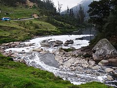
 Birth of Funza or Bogotá River in Guacheneque Páramo (Villapinzón)
 -
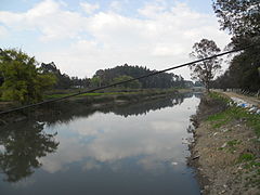
 Bogotá River close to Zipaquirá
 -
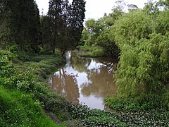
 Bogotá River in Engativá
 -
 Bogotá River close to Tequendama
 -
 Tequendama Falls in the Bogotá River


See also
- List of rivers of Colombia
- Bogotá savanna, Tequendama – archaeological site, earliest inhabitation along the Bogotá River
- Tequendama Falls
References
- ^ (in Spanish) Etymology Bacatá – Banco de la República
- ^ (in Spanish) A orillas del Río – El Tiempo
External links
- (in Spanish) Sistema Hídrico, Bogotá
- (in Spanish) Hidrografía Río Bogotá
 | Administrative subdivision in 20 localities | .svg) | |
|---|---|---|---|
| Metropolitan Area | |||
| Geography |
| ||
| |||||||||||||||||||
| |||||||||||||||||||
| |||||||||||||||||||
| |||||||||||||||||||
| Neighbours |
| ||||||||||||||||||

Research and collections | |||||||||
|---|---|---|---|---|---|---|---|---|---|
| |||||||||