
Lahaul and Spiti district
Lahaul and Spiti district | ||
|---|---|---|
Vidhan Sabha constituencies 01 | | |
| Area | ||
| • Total | 13,833 km2 (5,341 sq mi) | |
| Population (2011) | ||
| • Total | 31,564 | |
| • Density | 2.3/km2 (5.9/sq mi) | |
| • Urban | None | |
| Demographics | ||
| • Literacy | 86.97% (male), 66.5% (female) | |
| • Sex ratio | 916 | |
| Time zone | UTC+05:30 (IST) | |
| Vehicle registration | HP-41, HP-42, HP-43 | |
| Major highways | one (Manali-Leh National Highway) | |
| Average annual precipitation | Scanty rainfall | |
| Website | https://hplahaulspiti.gov.in | |
The Lahaul and Spiti district in the
Geography
Geologically located in the
Spiti is barren and difficult to cross, with an average elevation of the valley floor of 4,270 m (14,010 ft). It is surrounded by lofty ranges, with the
The district has close cultural links with Ngari Prefecture of Tibet Autonomous Region.[5]
Flora and fauna

The harsh conditions of Lahaul permit only scattered tufts of hardy grasses and shrubs to grow, even below 4 km (13,000 ft). Glacier lines are usually found at 5 km (16,000 ft). Due to changes in climate, people in the Lahaul valley are able to grow some vegetables like cabbages, potatoes, green peas, radishes, tomatoes, carrots and leafy vegetables. The main cash crops are potatoes, cabbages, and green peas.
Some of the most common species of flora found in the Valley of Spiti include
Over-hunting and a decrease in food supplies have led to a large reduction in the population of the Tibetan antelope, argali, kiangs, musk deer, and snow leopards in these regions, reducing them to the status of endangered species. The locals of Spiti do not hunt these wild animals due to their religious beliefs.
Kibber Wildlife Sanctuary
Kibber Wildlife Sanctuary [8] is the largest wildlife sanctuary in Himachal Pradesh. It is situated at an altitude of 3600m to 6700m,[9] on the left bank of the Spiti River in the district of Lahaul and Spiti. It is sprawled over an area of 2220.12sq km. This cold desert area sanctuary was declared a wildlife sanctuary in 1992. The fauna of Kibber Wildlife Sanctuary includes ibex, snow leopard, blue sheep, and birds such as snow cock, griffons, and bearded eagle. The flora consists of Monkshood, Somlata, Pink Arnebia, Orchid, and Gentian.
Demographics

According to the
Languages and cultures
41% of the population speaks
The language, culture, and populations of Lahaul and Spiti are closely related. Generally, the Lahaulis are of
The language spoken by both the Lahauli and Spiti Bhots is Bhoti, a Tibetic language of the Western Innovative subgroup. They are very similar to the Ladakh and Tibetans culturally, as they had been placed under the rule of the Guge and Ladakh kingdoms at occasional intervals.
Among the Lahaulis, the family acts as the basic unit of kinship. The extended family system is common and evolved from the polyandric system of the past. The family is headed by a senior male member, known as the Yunda, while his wife, known as the Yundamo, attains authority by being the oldest member of the generation. The clan system, also known as Rhus, plays another major role in the Lahauli society.
The Spiti
| Year | Pop. | ±% p.a. |
|---|---|---|
| 1901 | 12,392 | — |
| 1911 | 12,981 | +0.47% |
| 1921 | 12,836 | −0.11% |
| 1931 | 13,733 | +0.68% |
| 1941 | 14,594 | +0.61% |
| 1951 | 15,338 | +0.50% |
| 1961 | 23,682 | +4.44% |
| 1971 | 27,568 | +1.53% |
| 1981 | 32,100 | +1.53% |
| 1991 | 31,294 | −0.25% |
| 2001 | 33,224 | +0.60% |
| 2011 | 31,564 | −0.51% |
| source:[11] | ||
Lifestyle
The lifestyles of the Lahauli and Spiti Bhot are similar, owing to their proximity. Polyandry was widely practised by the Lahaulis in the past, although this practice has been dying out. The Spiti Bhot does not generally practice polyandry anymore, although it is accepted in a few isolated regions.
Divorces are accomplished by a simple ceremony performed in the presence of village elders. Divorce can be sought by either partner. The husband has to pay compensation to his ex-wife if she does not remarry. However, this is uncommon among the Lahaulis.
Agriculture is the main source of livelihood. Potato farming is common. Occupations include animal husbandry, working in government programs and services, and other businesses and crafts that include weaving. Houses are constructed in the Tibetan architectural style, as the land in Lahul and Spiti is mountainous and quite prone to earthquakes.[12]
Religion

Most of the Lahaulis follow a combination of
Before the spread of
The Losar festival (also known as Halda in Lahauli) is celebrated between the months of January and February. The date of the celebration is decided by the Lamas. It has the same significance as the Diwali festival of Hinduism, but is celebrated in a Tibetan fashion.
At the start of the festival, two or three persons from every household will walk in the procession holding burning incense. The burning sticks are then piled into a bonfire. The people will then pray to Shiskar Apa, the goddess of wealth (another name Vasudhara) in the Buddhist religion.
Buddhist monasteries
Spiti is one of the important centers of Buddhism in Himachal Pradesh. It is popularly known as the 'land of lamas'. The valley is dotted by numerous Buddhist Monasteries or Gompas. These are some of the important monasteries in the Lahul and Spiti valleys.
Kye Monastery:
Tabo Monastery: Perched at an altitude of 3050 meters, Tabo Monastery is often referred to as the 'Ajanta of the Himalayas'. It is located 45 km from Kaza, Himachal Pradesh, the capital of the Spiti region. This monastery garnered interest when it celebrated its thousandth year of existence in 1996. The Tabo Monastery was founded by scholar Richen Zangpo. The monastery houses more than 60 lamas and contains a collection of rare scriptures, pieces of art, and wall paintings - Thankas, and Stucco. There is a modern guest house with a dining hall and amenities.
Kardang Monastery:
Tnagyud Gompa: Built during the early decade of 14th century, Tnagyud Gompa is of historical importance and belongs to the Sa-kya-pa sect.[14]
Kungri Gompa: This is the second oldest monastery of Spiti, and is located in Pin valley.
Tourism
The natural scenery and numerous Buddhist monasteries are the main tourist attractions of the region.
The dangerous weather in Lahaul and Spiti permits visitors only between the months of June to October when the roads and villages are free of snow and the high passes (Rothang La and Kunzum La) are open. It is possible to access Spiti from
Adventure tourism
To-do-Trails: The Spiti Valley is popular with trekkers due to the challenging nature of its treks. These treks take people to remote areas including rural villages and old Gompas, as well as wildlife trails. High-altitude treks allow travelers to cross passes such as Parangla Pass (connecting Ladakh with Spiti Valley), Pin Parvati Pass, Baba Pass, Hamta Pass trek, and Spiti Left Bank Trek. Popular trekking routes in the area include Kaza-Langza-Hikim-Komic-Kaza, Kaza-Ki-Kibber-Gete-Kaza, Kaza-Losar-Kunzum La, and Kaza-Tabo-Sumdo-Nako.
Skiing: Skiing is a popular activity with tourists in Spiti.
Yak Safari: Yak rides are used to see the flora and fauna of the trans-Himalayan desert.
Notable people from Lahaul and Spiti
- Subedar Major & Hony Captain Bhim Chand, VrC & bar, 'Saviour of Ladakh'
- Subedar Major & Hony Captain Chhering Norbu Bodh, SC, mountaineer
- Colonel Thakur Prithi Chand, MVC, 'Saviour of Ladakh'
- Lieutenant Colonel Kushal Chand, MVC, 'Saviour of Ladakh'
- Lata Thakur, politician
- Parvati Devi Deskit Wangmo (born 1934), Queen mother of Ladakh and Ladakh politician
- Phunchog Rai, politician
- Ram Lal Markanda, politician
- Skalzang Dorje, Olympic archer
- Thakur Devi Singh, politician
- Tobdan, scholar
- Tshering Dorje, scholar
Politics
| Year | Member | Picture | Party | |
|---|---|---|---|---|
| 1967 | Thakur Devi Singh | Independent
| ||
| 1972 | Lata Thakur | Indian National Congress | ||
| 1977 | Thakur Devi Singh | Janata Party | ||
| 1982 | Indian National Congress | |||
| 1985 | ||||
| 1990 | Phunchog Rai | Indian National Congress | ||
| 1993 | ||||
| 1998 | Ram Lal Markanda | Himachal Vikas Congress | ||
| 2003 | Raghbir Singh Thakur | Indian National Congress | ||
| 2007 | Ram Lal Markanda | Bharatiya Janata Party | ||
| 2012 | Ravi Thakur | Indian National Congress | ||
| 2017 | Ram Lal Markanda[15] | Bharatiya Janata Party | ||
| 2022 | Ravi Thakur[16] | Indian National Congress | ||
| No. | Constituency | Member | Party | Remarks | Reference | |
|---|---|---|---|---|---|---|
| 21 | Lahaul and Spiti (ST)
|
Ram Lal Markanda | Bharatiya Janata Party | Technical Education Minister | ||
Gallery
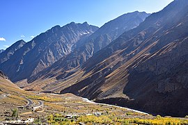
Bhaga valley
From Baralacha La to the confluence at Tandi, Lahaul.
-
 Bara-lacha la pass between Lahaul and Ladakh
 -
 Deepak Taal, en route to Bara-lacha la
 -
-
 Prayer hall, Gemur Monastery, Lahaul
 -
 Farmer crosses Bhaga on jhulla, Gemur
 -
 Thenu village on the Bhaga River, Lahaul


Chandra-Bhaga (Chenab) valley
From the confluence of the Chandra and Bhaga rivers at Tandi to Chamba district border downstream of Udaipur, Lahaul
-
 Villages on the Chandra-Bhaga near Udaipur, Lahul
 -
 Ripe cherries for harvesting, Udaipur
 -
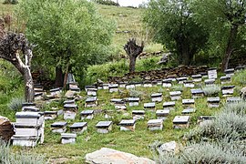 Bee hives for wildflower honey, Udaipur


Chandra valley
From the confluence at Tandi to Kunzum La separating Lahaul and Spiti
-
 Gondla Fort
 -
 Wildflowers and mountains, Sissu, Lahaul
 -
 Ghepan Monastery stupa, Sissu
 -
 Prayer stone, Ghepan Monastery, Sissu
 -
 Tributary of Chandra River from Rohtang Pass
 -
 Chandra River
 -
 Kunzum Pass between Lahul and Spiti


Spiti valley
From Kunzum La to the border with Kinnaur district at Sumdo, Spiti.
-
 Losar Khas, first village on the Spiti river
 -
 Kibber village and wildlife sanctuary, Spiti
 -
 Pea plants,Mud village, Spiti
 -
 Pin river valley, Spiti
 -
 Yellow-billed chough, Pin Valley
 -
 Graveyard of lamas, Tabo Monastery, Spiti


See also
- List of highest towns by country
- Lahuli–Spiti languages
- Lahuli language (disambiguation)
- Spiti Bhoti
- Lahul Lohar language
References
- ^ a b c d e "District Census Handbook: Lahaul and Spiti" (PDF). censusindia.gov.in. Registrar General and Census Commissioner of India. 2011.
- ^ "Kunzum Pass". india9.com.
- ^ Kapadia (1999). pp. 215-216.
{{cite book}}: CS1 maint: numeric names: authors list (link) - ^ Kapadia (1999). pp. 26-27.
{{cite book}}: CS1 maint: numeric names: authors list (link) - ^ "Kinnaur-Ngari Corridor: An Argument for The Revival of The Western Himalayan Silk Route - Himachal Watcher". 21 November 2019. Retrieved 1 August 2020.
- S2CID 129730525. Retrieved 1 August 2022.
- ^ "Snow Leopard Sightings Rising in Spiti valley". Raacho Trekkers. 2 February 2022.
- ISSN 0971-8257. Retrieved 17 September 2023.
- ^ him_admin. "Sanctuaries". Himachal Tourism Official Website. Retrieved 17 September 2023.
- ^ a b "Table C-16 Population by Mother Tongue: Himachal Pradesh". www.censusindia.gov.in. Registrar General and Census Commissioner of India.
- ^ Decadal Variation In Population Since 1901
- ^ "References - Lahaul Spiti Travel - Lahaul Spiti Tourist Guide". Lahaul Spiti Travel - Lahaul Spiti Tourist Guide. Retrieved 28 May 2018.
- ^ "Table C-01 Population by Religion: Himachal Pradesh". censusindia.gov.in. Registrar General and Census Commissioner of India. 2011.
- ^ "Monasteries in Spiti | District Lahaul and Spiti, Government of Himachal Pradesh | India". Retrieved 21 September 2023.
- ^ Election Commission of India. "Himachal Pradesh General Legislative Election 2017". Retrieved 8 July 2021.
- ^ Election Commission of India. "Himachal Pradesh General Legislative Election 2022". Retrieved 8 July 2022.
Bibliography
- Ciliberto, Jonathan. (2013). "Six Weeks in the Spiti Valley". Circle B Press. 2013. Atlanta. ISBN 978-0-9659336-6-7
- Handa, O. C. (1987). Buddhist Monasteries in Himachal Pradesh. Indus Publishing Company, New Delhi. ISBN 81-85182-03-5.
- Hutchinson, J. & J. PH Vogel (1933). History of the Panjab Hill States, Vol. II. (1st ed) Lahore: Govt. Printing, Punjab, 1933. Reprint 2000. Department of Language and Culture, Himachal Pradesh. Chapter X Lahaul, pp. 474–483; Spiti, pp. 484–488.
- Kapadia, Harish. (1999). Spiti: Adventures in the Trans-Himalaya. 2nd ed. New Delhi: Indus Publishing Company. ISBN 81-7387-093-4.
- Janet Rizvi. (1996). Ladakh: Crossroads of High Asia. Second Edition. Oxford University Press, Delhi. ISBN 0-19-564546-4.
- Cunningham, Alexander. (1854). LADĀK: Physical, Statistical, and Historical with Notices of the Surrounding Countries. London. Reprint: Sagar Publications (1977).
- Francke, A. H. (1977). A History of Ladakh. (Originally published as, A History of Western Tibet, (1907). 1977 Edition with critical introduction and annotations by S. S. Gergan & F. M. Hassnain. Sterling Publishers, New Delhi.
- Francke, A. H. (1914). Antiquities of Indian Tibet. Two Volumes. Calcutta. 1972 reprint: S. Chand, New Delhi.
- Banach, Benti (2010). 'A Village Called Self-Awareness, life and times in Spiti Valley'. Vajra Publications, Kathmandu ISBN 9937506441.
External links
 Lahaul and Spiti travel guide from Wikivoyage
- Official Website of the district
Places adjacent to Lahaul and Spiti district | ||||||||||||||||
|---|---|---|---|---|---|---|---|---|---|---|---|---|---|---|---|---|
| ||||||||||||||||
 | ||||
| Rivers | ||||
| Districts | ||||
| Other |
| |||
| International | |
|---|---|
| National | |