
Kargil district
Kargil district | ||
|---|---|---|
Deputy Commissioner Santosh Sukhadeve, IAS | | |
| • Chief Executive Councillor | Feroz Ahmed Khan, JKNC | |
| • Lok Sabha constituencies | Ladakh | |
| • MP | Jamyang Tsering Namgyal[2] | |
| Area | ||
| • Total | 14,086 km2 (5,439 sq mi) | |
| Population (2011) | ||
| • Total | 140,802 | |
| • Density | 10.0/km2 (26/sq mi) | |
| • Urban | 16,338 | |
| Demographics | ||
| • Literacy | 71.34% | |
| • Sex ratio | 810 ♀/ 1000 ♂ | |
| Languages | ||
| • Official | Hindi and English[3] | |
| • Spoken | Purgi, Shina, Ladakhi, Urdu, Balti, Tibetan, Punjabi | |
| Time zone | UTC+05:30 (IST) | |
| Vehicle registration | LA-01 | |
| Website | kargil | |
Kargil district is a district in Indian-administered Ladakh in the disputed Kashmir-region.[1] It is one of the two districts comprising the Indian-administered
The district was created in 1979, when Ladakh was part of the state of Jammu and Kashmir,[4] separating it from Leh district. In 2003, Kargil was granted a Ladakh Autonomous Hill Development Council (LAHDC). In 2019, Ladakh became a union territory, with Kargil and Leh being its joint capitals.
Shia Muslims comprise the majority of the population of the district, with Buddhists forming a significant minority, mainly inhabiting the Zanskar tehsil.
Geography

The Kargil district lies between the crest of the
The Suru River has two significant tributaries: Wakha Rong,[a] which flows northwest from Namika La to join the Suru River near Kargil, and the Dras River, which originates near the Zoji La pass and joins the Suru River a short distance north of Kargil.[b] Wakha Rong, also called the "Purik river", contains the main travel route between Kargil and Leh, and lent its name to the Kargil region itself as "Purig".[5] The Dras River valley has historically been a subdivision called Drass.
Zanskar was a traditional Buddhist kingdom formed in the 10th century, which became subject to the Ladakhi kings.
Per the 2011 census, the Kargil tehsil, which includes the Drass and Wakha Rong valleys, contains 61% of the population of the district. The Sankoo tehsil, representing the upper Suru valley, contains 10% of the population and the Zanskar tehsil contains 29% of the population.[6]
Vulnerability of natural disasters
The Kargil district is particularly vulnerable to landslides, cloudbursts, and flash floods. The main highways connecting Kargil with adjacent regions (NH-1D and NH-301) are prone to landslides. Recurring flash floods were observed in the surroundings of the Kargil town in 2006, 2010, 2013, 2014, 2016 and 2018. These flash floods caused massive damages to roads, buildings, and agricultural area.[7]
History
Buddhist dynasties

Purig is believed to have been conquered, along with Ladakh proper (modern
The Suru Valley was historically ruled from
The principality of Kartse apparently controlled the entire western Ladakh, from
Medieval period
Islam arrived in the Kashmir Valley around 1320, a new force to be reckoned with. During the rule of Sultan Sikandar (r. 1394–1416), his general Rai Madari crossed the Zoji La pass and conquered Purig and Baltistan. This paved the way for the conversion of the two regions to Islam.[15] Sultan Zain-ul-Abidin ran an expedition to Tibet, conquering Ladakh along the way. The Tri-gyal of Kartse is said to have become his vassal and assisted in the invasions.[16] The first dynasty of Ladakh did not last much longer after this.[17] A second "Namgyal" dynasty was established around 1460 AD.[18]
Some time after this, a Muslim chieftaincy connected to
During the invasion of Ladakh byIn 1586, Kashmir became a Mughal province. Purig and Baltistan were Islamic, and Mughal involvement in the affairs of the region became endemic. In 1638, emperor Shah Jahan sent a force to intervene in Baltistan and installed Ali Mir's son Adam Khan as the ruler. The joint forces of Mughal Kashmir and Adam Khan blocked Sengge Namgyal's efforts to regain Purig, forcing him to sue for peace. When Sengge Namgyal reneged on his tribute, the emperor imposed economic sanctions against Ladakh barring all trade, which impoverished Ladakh.[23]
Under his son Deldan Namgyal (Bde-ldan-rnam-rgyal) between 1640 and 1675, Purig returned to the control of Ladakh. Zanskar and other parts of the modern Ladakh Division were also conquered.[24]
Princely State of Jammu and Kashmir
In 1834, the
The Purigis rebelled repeatedly, instigated by Sikh governor Mihan Singh of Kashmir. They also received support from Ahmed Shah of Baltistan. Zorawar Singh returned in 1839 to quell the rebellion and conquered Baltistan as well.[27][28]
After the conquest, the region of the present Kargil district was organised into three ilaqas of the Kishtwar wazarat,[e] based at Kargil, Dras and Zanskar respectively. They were headed by civil officers called Thanadars.[29] Later, Suru was made into a separate ilaqa.[30]
Following the
In 1901, a major reorganisation of the frontier districts took place. A new Ladakh wazarat was created, being one of the two wazarats of the Frontier Districts province. Kargil was made a new tehsil under the Ladakh wazarat, with the three Purig ilaqas (Drass, Kargil and Suru), the Zanskar ilaqa from the Kishtwar district, and the
Post-1947

During the
During the
In 1979, Ladakh was divided into Kargil and Leh districts within the Jammu and Kashmir state.
Kargil War
In the spring of 1999, under a covert plan of then Pakistan Army chief Pervez Musharraf, armed infiltrators from Baltistan, aided by the Pakistani Army, occupied vacant high-altitude posts in the Kargil and Drass regions. The result was a limited-scale conflict (Kargil War) between the two nuclear-equipped nations, which ended with India regaining the Kargil region through military action and diplomatic pressure. However, there remains the controversy of the mountain peak, knows as Point 5353 or the Marpo La Peak, which is still believed to be under Pakistan's control.
Ladakh union territory
In August 2019 the
Climate

Kargil district is situated in the deep south-western part of the
The climate is cold and temperate. The average annual temperature in Kargil is 8.6 °C. About 318 mm of precipitation falls annually. The driest month is November with 6 mm. Most precipitation falls in March, with an average of 82 mm. The warmest month of the year is July with an average temperature of 23.3 °C. In January, the average temperature is −8.8 °C. It is the lowest average temperature of the whole year. The difference in precipitation between the driest month and the wettest month is 76 mm. The average temperatures vary during the year by 32.1 °C.[39]
| Climate data for Kargil, India | |||||||||||||
|---|---|---|---|---|---|---|---|---|---|---|---|---|---|
| Month | Jan | Feb | Mar | Apr | May | Jun | Jul | Aug | Sep | Oct | Nov | Dec | Year |
| Mean daily maximum °C (°F) | −4.3 (24.3) |
1.6 (34.9) |
4.3 (39.7) |
13.5 (56.3) |
20.9 (69.6) |
25.7 (78.3) |
29.2 (84.6) |
28.6 (83.5) |
24.2 (75.6) |
17.8 (64.0) |
9.8 (49.6) |
0.9 (33.6) |
14.4 (57.8) |
| Mean daily minimum °C (°F) | −13.2 (8.2) |
−11.9 (10.6) |
−4.9 (23.2) |
3.3 (37.9) |
9 (48) |
13.3 (55.9) |
17.4 (63.3) |
17 (63) |
12 (54) |
4.9 (40.8) |
−1.6 (29.1) |
−8.1 (17.4) |
3.1 (37.6) |
| Average precipitation mm (inches) | 46 (1.8) |
51 (2.0) |
82 (3.2) |
35 (1.4) |
26 (1.0) |
11 (0.4) |
7 (0.3) |
10 (0.4) |
10 (0.4) |
8 (0.3) |
6 (0.2) |
26 (1.0) |
318 (12.4) |
| Source: Climate-Data.org[40] | |||||||||||||
Administration

The Kargil district was formed in July 1979, by separating it from Leh. Kargil has 5 Sub-Divisions, 8 tehsils, and 14 Blocks.
Sub-Divisions (5):
)Tehsils (8):
)Blocks (14): Drass, Kargil, Shakar, Chiktan, Shargole, Sankoo, Trespone, Saliskote, Gund Mangalpore, Taisuru, Padum, Lungnaq, Cha, Zangla
Each block consists of a number of panchayats.
Politics
Kargil district had two assembly constituencies, Zanskar and Kargil under Jammu and Kashmir Legislative Assembly.
Ladakh, a union territory without a legislature, does not have a legislative assembly but is represented in the Parliament.[42]
Santosh Sukhadeve, (IAS) is the current District Development Commissioner Kargil.[43]
Autonomous Hill Council
Kargil District is administered by an elected body known as the Ladakh Autonomous Hill Development Council, Kargil. The LAHDC-K was established in 2003.[44]
Demographics

According to the
Religion
Of the total population, 77% are Muslims, of which 63% follow
Much of Kargil population is inhabited by the
have also settled in Kargil town.| Kargil district: religion, gender ratio, and % urban of population, according to the 2011 Census.[47] | |||||||||
|---|---|---|---|---|---|---|---|---|---|
| Hindu | Muslim | Christian | Sikh | Buddhist | Jain | Other | Not stated | Total | |
| Total | 10,341 | 108,239 | 604 | 1,171 | 20,126 | 28 | 4 | 289 | 140,802 |
| 7.34% | 76.87% | 0.43% | 0.83% | 14.29% | 0.02% | 0.00% | 0.21% | 100.00% | |
| Male | 9,985 | 55,762 | 532 | 1,101 | 10,188 | 16 | 3 | 198 | 77,785 |
| Female | 356 | 52,477 | 72 | 70 | 9,938 | 12 | 1 | 91 | 63,017 |
| Gender ratio (% female) | 3.4% | 48.5% | 11.9% | 6.0% | 49.4% | 42.9% | 25.0% | 31.5% | 44.8% |
| Sex ratio (no. of females per 1,000 males) |
936 | 941 | 135 | 964 | 975 | – | – | – | 810 |
| Urban | 3,139 | 12,671 | 63 | 360 | 88 | 2 | 1 | 14 | 16,338 |
| Rural | 7,202 | 95,568 | 541 | 811 | 20,038 | 26 | 3 | 275 | 124,464 |
| % Urban | 30.4% | 11.7% | 10.4% | 30.7% | 0.4% | 7.1% | 25.0% | 4.8% | 11.6% |
Languages

The Purgi dialect of Balti is spoken by 65% while 10 per cent speak Shina language in regions like Drass and Batalikis.[50] Urdu is also spoke and understood in kargil.[51]
Balti language has four variants/dialects and Purgi is the southern dialect of Balti language. Balti, is a branch of Archaic Western Tibetan language, is also spoken by the inhabitants of the four districts of (
Culture
Though earlier Tibetan contact has left a profound influence upon the people of both Kargil and Leh, after the spread of Shia Islam the people of Kargil were heavily influenced by Persian culture. This is apparent by the use of Persian words and phrases as well as in songs called
Social ceremonies such as marriages still carry many customs and rituals that are common to both the Muslims and Buddhists. Among the two districts of Ladakh, Kargil has a more mixed ethnic population and thus there are more regional dialects spoken in Kargil as compared to Leh. Local folk songs, which are called
Wildlife
Endangered species
Kargil is home to many endangered wildlife species:
- Snow leopard (Panthera uncia)
- Tibetan wolf (Canis lupus langier)
- Himalayan brown bear (Ursus arctos isabellinus)
- Asiatic ibex (Capra ibex)
- Ladakh urial (Ovis vignei vignei)
- musk deer (Moschus spp.)
- pikas
- marmots and hares.
Some of the reptiles found in Kargil district are
- Platyceps ladacensis (Ladakh cliff racer)[56]
- Phrynocephalus theobaldi (toad head agama)
- Altiphylax stoliczkai (Balti gecko)
- Paralaudakia himalayana (Himalayan agama)
- Asymblepharus ladacensis (Ladakh ground skink).
Aishwarya Maheshwari of the
Birds
Besides the endangered species, various birds are commonly seen in summer:
- Black-necked Eurasian magpie
- house sparrow
- hoopoe[60]
- rosefinches
- red-billed choughs
- eastern chiffchaff
- common sandpiper
- European goldfinches.[61]
Gallery
-
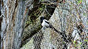 The Eurasian magpie, a common sight in Kargil
 -
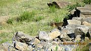 A marmot, found in the wild in Ladakh
 -
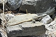
 Ladakh toad head agama (Phrynocephalus theobaldi) at Kargil campus of the University of Ladakh
 -
 An adult Himalayan Agama (Paralaudakia himalayana) at Ringmospang, Kargil
 -
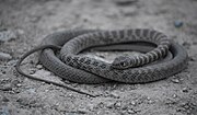 An adult Ladakh cliff racer (Platyceps ladacensis), from Gongma Minji, Kargil
 -
 European goldfinch (Carduelis carduelis) at Ringmospang, Kargil


.jpg)
Transportation
Road
Kargil is connected to the rest of India by one high-altitude road which is subject to landslides and is impassable in winter due to deep snows. The
- Nimmu–Padam–Darcha road
This is the third road axis to Leh through Zanskar in Kargil district. The construction of road was completed in March 2024.[64][65]
Air
Kargil Airport is a non-operational airport used only for defence purposes by the Indian Air Force. Kargil Airport has been included under Central Govt.'s UDAN scheme for commercial operations.[66][67] The nearest operational airport is Leh's Kushok Bakula Rimpochee Airport which is located 215 kilometres from Kargil.
Rail
There is no railway service currently in Ladakh, however, 2 railway routes are proposed- the Bhanupli–Leh line and Srinagar–Kargil–Leh line.[68]
See also
- List of districts of Ladakh
- Geography of Ladakh
- Tourism in Ladakh
- Ladakh Autonomous Hill Development Council, Kargil
Notes
- ^ Alternatively, Wakha Chu, Wakka Chu or Wakkha Chu
- ^ Technically, the Suru River is considered a tributary of the Dras River since the latter comes with a greater volume. But the combined river flows north essentially through the channel of the Suru River.
- Wakha Rong and Drasvalleys (on the route between Zoji La and upper Ladakh) were under Ladakhi control, but Suru, being a side valley of the main route, might have remained independent, outside the domain of "Purig" until modern period.
- ^ Baghan is described as "a Chui of the provinces of Tibet", which is taken to mean "headman" by Petech.
- ^ The term "ilaqa" has the rather generic meaning of "area". It was the smallest unit of administration at that time, comparable to the present day community development blocks.
References
- ^ due weightin the coverage. Although "controlled" and "held" are also applied neutrally to the names of the disputants or to the regions administered by them, as evidenced in sources (h) through (i) below, "held" is also considered politicised usage, as is the term "occupied," (see (j) below).
(a) Kashmir, region Indian subcontinent, Encyclopaedia Britannica, retrieved 15 August 2019 (subscription required) Quote: "Kashmir, region of the northwestern Indian subcontinent ... has been the subject of dispute between India and Pakistan since the partition of the Indian subcontinent in 1947. The northern and western portions are administered by Pakistan and comprise three areas: Azad Kashmir, Gilgit, and Baltistan, the last two being part of a territory called the Northern Areas. Administered by India are the southern and southeastern portions, which constitute the state of Jammu and Kashmir but are slated to be split into two union territories.";
(b) Pletcher, Kenneth, Aksai Chin, Plateau Region, Asia, Encyclopaedia Britannica, retrieved 16 August 2019 (subscription required) Quote: "Aksai Chin, Chinese (Pinyin) Aksayqin, portion of the Kashmir region, at the northernmost extent of the Indian subcontinent in south-central Asia. It constitutes nearly all the territory of the Chinese-administered sector of Kashmir that is claimed by India to be part of the Ladakh area of Jammu and Kashmir state.";
(c) "Kashmir", Encyclopedia Americana, Scholastic Library Publishing, 2006, p. 328,ISBN 978-1-84904-621-3Quote:"Some politicised terms also are used to describe parts of J&K. These terms include the words 'occupied' and 'held'." - ^ "Lok Sabha Members". Lok Sabha. Retrieved 12 July 2021.
- Outlook India. Archivedfrom the original on 7 April 2022. Retrieved 8 April 2022.
- ^ District Census Handbook (2011), p. 7.
- ^ Grist, Urbanisation in Kargil (2008), p. 80.
- ^ District Census Handbook (2011), Maps preamble.
- ^ Altaf Hussain; Susanne Schmidt; Marcus Nüsser (2023). Urban Landscape Change in the Trans-Himalayan Town of Kargil, Ladakh, India (Report). Copernicus Meetings.
- ^ Francke, A History of Western Tibet (1907), pp. 60–63.
- ^ Petech, The Kingdom of Ladakh (1977), pp. 17: "The first-born, usually called dPal-gyi-mgon, took Ladakh; it seems that his father bequeathed him a theoretical right of sovereignty, but the actual conquest was effected by dPal-gyi-mgon himself."
- ^ Fisher, Rose & Huttenback, Himalayan Battleground (1963): "The Ladakhi chronicles state that the eldest son, Pal-gyi-gön (Dpal-gyi-mgon), received Ladakh and the Rudok area; the second son, Tra-shi-gön (Bkra-shis-mgon), Guge and Purang; while the third son, De-tsuk-gön (Lde-gtsug-mgon), was given Zanskar, Spiti and Lahul."
- ^ Francke, A History of Western Tibet (1907), p. 48.
- ^ Francke, A History of Western Tibet (1907), p. 63.
- JSTOR 40393242
- ^ Francke, A History of Western Tibet (1907), pp. 273–274.
- ^ Petech, The Kingdom of Ladakh (1977), p. 22.
- ^ Francke, A History of Western Tibet (1907), p. 273.
- ^ Petech, The Kingdom of Ladakh (1977), p. 23.
- ^ a b Petech, The Kingdom of Ladakh (1977), p. 28.
- ^ Devers, Buddhism before First Diffusion? (2020), paragraphs 31–32, note 17.
- ^ Petech, The Kingdom of Ladakh (1977), p. 26.
- ^ Howard, What happened between 1450 and 1550 AD? (1997), pp. 130–131.
- ^ Devers, Buddhism before First Diffusion? (2020), note 17.
- ^ Petech, The Kingdom of Ladakh (1977), pp. 49–51.
- ^ Huttenback, Gulab Singh and the Creation of the Dogra State (1961), p. 477.
- ^ Huttenback, Gulab Singh and the Creation of the Dogra State (1961), p. 480.
- ^ Panikkar, Gulab Singh (1930), pp. 77–78.
- ^ Huttenback, Gulab Singh and the Creation of the Dogra State (1961), pp. 481–482.
- ^ Panikkar, Gulab Singh (1930), pp. 78–80.
- ^ Cunningham, Ladak (1854), p. 274.
- ^ Gazetteer of Kashmir and Ladak (1890), p. 804.
- ^ Panikkar, Gulab Singh (1930), p. 112.
- ^ Gazetteer of Kashmir and Ladak (1890), p. 194.
- ^ Aggarwal, Beyond Lines of Control (2004), p. 35.
- ^ Kargil: what might have happened By Javed Hussain 21 October 2006, Dawn
- ^ "Assault on Enemy OPs in Kargil". The Liberation Times. 8 December 1971. Archived from the original on 5 November 2006. A dramatised account of India's assault on Kargil during the 1971 war. (a commemorative online newspaper)
- ^ Major General D.K. Palit (Retd.). "The Lightning Concept". Archived from the original on 2 May 2006.
- ^ The Armed Forces of Pakistan By Pervaiz Iqbal Cheema, Pg 4
- ^ "Article 370 revoked Updates: Jammu & Kashmir is now a Union Territory, Lok Sabha passes bifurcation bill". www.businesstoday.in. 6 August 2019.
- ^ Climate: Kargil - Climate graph, Temperature graph, Climate table
- ^ "Climatological Information for Kargil, Ladakh", Hong Kong Observatory, 2003. Web: HKO-Marrakech.
- ^ "ERO's and AERO's". Chief Electoral Officer, Jammu and Kashmir. Archived from the original on 22 October 2008. Retrieved 28 August 2008.
- ^ "J&K to be a union territory with legislature, Ladakh to be without". India Today. 5 August 2019. Retrieved 5 August 2019.
- ^ "Profile of Deputy Ccommissioners". Kargil.nic.in. Archived from the original on 27 July 2013. Retrieved 16 August 2013.
- ^ "Ladakh Autonomous Hill development Council act 1997" (PDF). Retrieved 26 January 2021.
- ^ "Kargil district census data 2011" (PDF). Archived from the original (PDF) on 20 February 2019. Retrieved 20 February 2019.
- ^ "Census of India: Search Details - Kargil district". Retrieved 31 October 2021.
- ^ a b c C-1 Population By Religious Community – Jammu & Kashmir (Report). Office of the Registrar General & Census Commissioner, India. Retrieved 28 July 2020.
- ISBN 978-0-8223-7730-6.
- ^ C-16 Population By Mother Tongue – Jammu & Kashmir (Report). Office of the Registrar General & Census Commissioner, India. Retrieved 18 July 2020.
- ^ Rather, Ali Mohammad (September 1999), "Kargil: The Post-War Scenario", Journal of Peace Studies, 6 (5–6), International Center for Peace Studies, archived from the original on 1 December 2014
- ^ "District Profile". Government of India, Ministry of Home Affairs, Office of the Registrar General & Census Commissioner. Archived from the original on 13 November 2013. Retrieved 19 September 2011.
- ^ Rather, Ali Mohammad (September 1999), "Kargil: The Post-War Scenario", Journal of Peace Studies, 6 (5–6), International Center for Peace Studies, archived from the original on 1 December 2014
- ISBN 0-19-564546-4.
- ^ Anjuman Jamiatul Ulama Houzai Elmiya Madrasa Asna Asharia Islamia School Kargil
- ^ IKMT Kargil
- S2CID 238052440.
- ^ "India, Pakistan and the Snow Leopard: Javed Naqi". Kafila. 28 January 2012. Retrieved 16 August 2013.
- ^ Voices from Frozen Land (24 January 2012). "Javed Naqi: Human-Wildlife Conflict in Kargil: Precipitation of India-Pakistan Rivalry?". Javed-naqi.blogspot.in. Retrieved 16 August 2013.
- ^ "Human-Wildlife Conflict in Kargil: Precipitation of India-Pakistan Rivalry? | Bargad... बरगद". Bargad.org. 1 February 2012. Archived from the original on 8 August 2014. Retrieved 16 August 2013.
- ISBN 9788177552577. Retrieved 16 August 2013 – via Google Books.
- ^ Alok Bhave (6 October 2011). "Nature watch: Trip to Cold Desert - Ladakh Part2". Alokbhave.blogspot.in. Retrieved 16 August 2013.
- ^ Pak considers Kargil-Skardu bus 15 March 2007 NDTV
- ^ "Centre clears ₹780-cr for Kargil-Zanskar road upgrade". NBMCW. 7 April 2021. Retrieved 7 April 2021.
- ^ "BRO connects 298-km long Nimmu-Padam-Darcha road to Ladakh region". Business Line. 26 March 2024. Retrieved 4 April 2024.
- ^ Ghoshal, Devjyot (29 September 2020). "High road at Chilling: India builds Himalayan bridges and highways to match China". Reuters. Retrieved 14 April 2024.
- ^ "Operationalisation of civilian flights to Kargil Airport reviewed". Daily Excelsior. 9 July 2021. Retrieved 9 July 2021.
- ^ "Ladakh L-G discusses air connectivity possibilities for Kargil with Centre". The Hindu. 19 June 2021. Retrieved 19 June 2021.
- ^ "Himachal CM meets Union railway minister, seeks 100% Centre funding for Bhanupali-Bilaspur-Leh rail line". Hindustan Times. Retrieved 9 November 2020.
Bibliography
- District Census Handbook: Kargil (PDF), Directorate of Census Operations, Jammu and Kashmir, 2011, archived from the original (PDF) on 21 November 2017
- Aggarwal, Ravina (2004), Beyond Lines of Control: Performance and Politics on the Disputed Borders of Ladakh, India, Duke University Press, ISBN 0-8223-3414-3
- Cunningham, Alexander (1854), Ladak: Physical, Statistical, Historical, London: Wm. H. Allen and Co – via Internet Archive
- Devers, Quentin (2020), "Buddhism before the First Diffusion? The case of Tangol, Dras, Phikhar and Sani-Tarungtse in Purig and Zanskar (Ladakh)", Études Mongoles & Sibériennes, Centrasiatiques & Tibétaines, 51 (51), S2CID 230579183
- Fisher, Margaret W.; Rose, Leo E.; Huttenback, Robert A. (1963), Himalayan Battleground: Sino-Indian Rivalry in Ladakh, Praeger – via archive.org
- Francke, Rev. A. H. (1907), A History of Western Tibet, S. W. Partridge & Co – via archive.org
- Gazetteer of Kashmir and Ladak, Calcutta: Superintendent of Government Printing, 1890 – via Internet Archive
- Grist, Nicola (2008). "Urbanisation in Kargil and its Effects in the Suru Valley". In Martijn van Beek; Fernanda Pirie (eds.). Modern Ladakh: Anthropological Perspectives on Continuity and Change. BRILL. ISBN 978-90-474-4334-6.
- Gupta, Radhika (2013). "Allegiance and Alienation: Border Dynamics in Kargil". In David N. Gellner (ed.). Borderland Lives in Northern South Asia. Duke University Press. pp. 47–71. ISBN 978-0-8223-7730-6.
- Howard, Neil (1997), "What happened between 1450 and 1550 AD? and other questions from the history of Ladakh", in Henry Osmaston; Nawang Tsering; International Association for Ladakh Studies (eds.), Recent Research on Ladakh 6: Proceedings of the Sixth International Colloquium on Ladakh, Leh 1993, Motilal Banarsidass Publ., pp. 121–138, ISBN 978-81-208-1432-5
- Huttenback, Robert A. (1961), "Gulab Singh and the Creation of the Dogra State of Jammu, Kashmir, and Ladakh" (PDF), The Journal of Asian Studies, 20 (4): 477–488, S2CID 162144034
- Karim, Maj Gen Afsir (2013), Kashmir The Troubled Frontiers, Lancer Publishers LLC, pp. 30–, ISBN 978-1-935501-76-3
- Petech, Luciano (1977), The Kingdom of Ladakh, c. 950–1842 A.D., Instituto Italiano Per il Medio ed Estremo Oriente – via archive.org
- Panikkar, K. M. (1930), Gulab Singh, London: Martin Hopkinson Ltd
- Ghulam Mohiuddin Dar. Kargil: Its social, culture, and economic history.
- Kargil : The Important Trade Transit of Yesteryears, People & Society
- Shireen M. Mazari, The Kargil Conflict, 1999: Separating Fact from Fiction, The Institute of Strategic Studies, Islamabad (2003) ISBN 969-8772-00-6
External links
- Official website
- Rivers of Kargil district on OpenStreetMap: Dras, Suru and Kartse, Wakha, Zanskar
- Ladakh Autonomous Hill Development Council, Kargil (archived 15 July 2010)
- Kargil Tehsil Map, MapsofIndia.com
- "Pakistan's Northern Areas dilemma", BBC
- Kargil War 1999, Rediff
Places adjacent to Kargil district | |
|---|---|
| International | |
|---|---|
| National | |