
Atbaichandi
Atbaichandi | |
|---|---|
Village | |
Taldangra | |
| Website | bankura |
Atbaichandi is a village in the
.Geography

8km
5miles
5miles
Kangsabati River
Kangsabati Project
Reservoir
Reservoir
Mandankuli
T
Pareshnath
T
Harmasra
T
Deulbhira
TV
Atbaichandi
T
Ambikanagar
T
Panchmura
C
Ledisol
CT
Simlapal
CT
Raipur
CT
Khatra
CT
Matgoda
R
Taldangra
R
Sarenga
R
Rautara
R
Ranibandh
R
Phulkusma
R
Mukutmanipur
R
Kharigerya
R
Jhilimili
R
Indpur
R
Hirbandh
R
Haludkanali
R
Barikul
R
Baragari
R
Places in Khatra subdivision in Bankura district
CT: census town, R: rural/ urban centre, C: craft centre, T: ancient/ temple centre
Owing to space constraints in the small map, the actual locations in a larger map may vary slightly
CT: census town, R: rural/ urban centre, C: craft centre, T: ancient/ temple centre
Owing to space constraints in the small map, the actual locations in a larger map may vary slightly
Location
Atbaichandi is located at 23°07′47″N 86°59′18″E / 23.1297°N 86.9883°E.
Note: The map alongside presents some of the notable locations in the subdivision. All places marked in the map are linked in the larger full screen map.
Demographics
According to the
2011 Census of India, Atbaichandi had a total population of 1,310, of which 658 (50%) were males and 652 (50%) were females. There were 190 persons in the age range of 0–6 years. The total number of literate persons in Atbaichandi was 693 (61.88% of the population over 6 years).[1]
Culture
Mallabhum, e.g. the three temples at Atbaichandi in Indpur PS, stand as evidence of extensive temple-building by the Rajas of Bishnupur. Although subject to occasional incursions, "their territory was largely beyond the sphere of Muslim influence."[2]
-
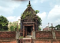 Basuli temple at Atbaichandi
 -
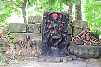 Atbaichandi idol in what remains of a temple
 -
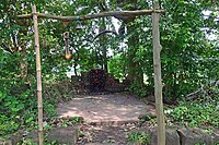 Atbaichandi idol in what remains of a temple


References
- ^ "CD block Wise Primary Census Abstract Data(PCA)". West Bengal – District-wise CD blocks. Registrar General and Census Commissioner, India. Retrieved 20 April 2020.
- ISBN 978-93-81574-65-2
External links
Wikimedia Commons has media related to Atbaichandi.
| ||||||||
|---|---|---|---|---|---|---|---|---|
| Cities, municipal and census towns |
|  | ||||||
| Locations other than cities and towns |
| |||||||
| Related topics | ||||||||
This article about a location in the Bankura district of West Bengal is a stub. You can help Wikipedia by expanding it. |