
Bhalia
Bhalia | |
|---|---|
Village | |
Arambag | |
| Website | hooghly |
Bhalia is a village in the
Geography

5miles
River
River
River
River
Bayara
M: municipal city/ town, R: rural/ urban centre, H: historical/ religious centre
Owing to space constraints in the small map, the actual locations in a larger map may vary slightly
Location
Bhalia is located at 22°53′47″N 87°51′44″E / 22.8963°N 87.8623°E
Area overview
The Arambagh subdivision, presented in the map alongside, is divided into two physiographic parts – the Dwarakeswar River being the dividing line. The western part is upland and rocky – it is extension of the terrain of neighbouring Bankura district. The eastern part is flat alluvial plain area. The railways, the roads and flood-control measures have had an impact on the area.[1] The area is overwhelmingly rural with 94.77% of the population living in rural areas and 5.23% in urban areas.[2]
Note: The map alongside presents some of the notable locations in the subdivision. All places marked in the map are linked in the larger full-screen map.
Demographics
According to the
Culture
David J. McCutchion mentions the Raghunatha temple of Sarkar family as an at chala with porch on triple archway, built in 1772 and measuring 24’ x 23’.[4]
Bhalia picture gallery
-
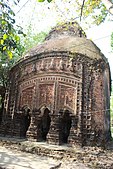 Raghunatha temple of Sarkar family, at chala, built in 1772
 -
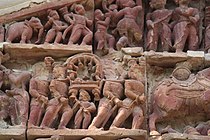 Terracotta relief in Raghunatha temple
 -
 Terracotta relief in Raghunatha temple


References
- ^ "District Census Handbook: Hugli, Series-20, Part XIIA" (PDF). Physiography, Page 17-19. Directorate of Census Operations, West Bengal, 2011. Retrieved 25 September 2020.
- ^ "District Statistical Handbook 2014 Hooghly". Table 2.2, 2.4(a). Department of Planning and Statistics, Government of West Bengal. Retrieved 25 September 2020.
- ^ "2011 Census – Primary Census Abstract Data Tables". West Bengal – District-wise. Registrar General and Census Commissioner, India. Retrieved 22 September 2020.
- ISBN 978-93-81574-65-2