
Bali Dewanganj
Bali Dewanganj | |
|---|---|
Village | |
Goghat | |
| Website | hooghly |
Bali Dewanganj (also referred to as only Bali) is a village and a
Geography

5miles
River
River
River
River
Bayara
M: municipal city/ town, R: rural/ urban centre, H: historical/ religious centre
Owing to space constraints in the small map, the actual locations in a larger map may vary slightly
Location
Bali Dewanganj is located at 22°48′44″N 87°46′06″E / 22.81224°N 87.76836°E. It is 13 km from Arambagh on the Arambagh-Ghatal Road.
Area overview
The Arambagh subdivision, presented in the map alongside, is divided into two physiographic parts – the Dwarakeswar River being the dividing line. The western part is upland and rocky – it is extension of the terrain of neighbouring Bankura district. The eastern part is flat alluvial plain area. The railways, the roads and flood-control measures have had an impact on the area.[1] The area is overwhelmingly rural with 94.77% of the population living in rural areas and 5.23% in urban areas.[2]
Note: The map alongside presents some of the notable locations in the subdivision. All places marked in the map are linked in the larger full screen map.
Demographics
As per the
Culture
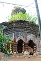
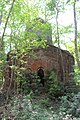
Bali Dewanganj is a temple town. The Rautpara neighbourhood alone has five temples, but unfortunately out of these, three are in a dilapidated condition. The Mangal Chandi temple is said to have had 13 pinnacles, and all of them have fallen. In the other two ruined temples one can still see one pinnacle each. The most important structure is the 200-years old Durga temple, maintained by the state archaeological department. It is a rare and unique structure, with a nava ratna superstructure placed on a Jor Bangla base. The Shiva kutir is another place in ruins. A ras mancha still has some terracotta decorations. The pictures in the gallery show a small selection of terracotta work in the different temples.[4]
David J. McCutchion mentions:[5]
- The Shiva Durga temple of Raut Family as a Jor Bangla with a nava ratna tower, measuring 21’ 10" square, with terracotta on façade, built possibly in the 18th century.
- The Damodara temple of the Ghosh family, as a Midnapore type at chala, measuring 22’ x 19’ 6", built in 1822.
- The Vishnu temple of Raut Family at Rautpara as a pancha ratna with curved ridging to the turrets, with slight terracotta, measuring 22’ 6" square.
- The Mangal Chandi temple, with rich terracotta decoration but ruined, is said to have had 13 turrets.
The temple of Shiva Durga at Bali Dewanganj (at Sr No S-WB-58) is included in the List of State Protected Monuments in West Bengal by the Archaeological Survey of India.[6]
Bali Dewanganj picture gallery
-
 The Shiva Durga temple (or simply Durga temple) with the Vishnu temple in the background
 -
 The massive terracotta panel in Shiva Durga temple
 -
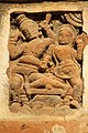 Terracotta panel in Shiva Durga temple
 -
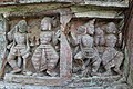
 Vishnu temple in Rautpara
 -
 Damodar temple of Ghosh family
 -
 Terracotta relief in Damodar temple
 -
 Lakshmi Janardan temple at Dalapara in a dilpidated condition
 -
 Terracotta relief in Lakshmi Janardan temple
 -
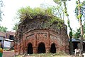 Magal Chandi temple at Rautpara. All the 13 turrets are gone.
 -
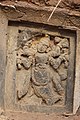 Terracotta relief in Mangal Chandi Temple
 -
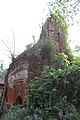
 Shib kuthi
 -
 Durga temple of Das family at Rautpara
 -
 Rasa Mancha
 -
 One of the many decorative pieces in Rasa Mancha
.jpg)
.jpg)
.jpg)


Click on the pictures to enlarge picture size
References
- ^ "District Census Handbook: Hugli, Series-20, Part XIIA" (PDF). Physiography, Page 17-19. Directorate of Census Operations, West Bengal, 2011. Retrieved 25 September 2020.
- ^ "District Statistical Handbook 2014 Hooghly". Table 2.2, 2.4(a). Department of Planning and Statistics, Government of West Bengal. Retrieved 25 September 2020.
- ^ "2011 Census – Primary Census Abstract Data Tables". West Bengal – District-wise. Registrar General and Census Commissioner, India. Retrieved 27 August 2018.
- ^ Datta, Rangan. "Next weekend you can be at Bali Dewanganj". The Telegraph, 4 April 2010. Retrieved 21 September 2020.
- ISBN 978-93-81574-65-2
- ^ "Protected Monuments in West Bengal". Archaeological Survey of India. Archived from the original on 3 September 2013. Retrieved 27 September 2020.