
Patit Dommahal
Patit Dommahal | |
|---|---|
Village | |
Indas | |
| Website | bankura |
Patit Dommahal is a village in the
.Geography

5miles
Purbapara
M: Municipal town, CT: census town, R: rural/ urban centre, T: ancient/ temple centre
Owing to space constraints in the small map, the actual locations in a larger map may vary slightly
Location
Patit Dommahal is located at 23°09′57″N 87°34′18″E / 23.1657°N 87.5717°E.
Note: The map alongside presents some of the notable locations in the subdivision. All places marked in the map are linked in the larger full screen map.
Demographics
According to the
Education
Patit High School is a Bengali-medium coeducational institution established in 1955. It has facilities for teaching from class V to class XII. The school has 10 computers, a library with 2,300 books and a playground.[2]
Patrasayer Mahavidyalaya was established in 2005 at Patrasayer[3][4]
Culture
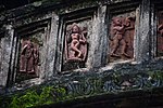
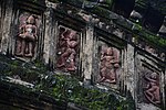
David J. McCutchion mentions the Sridhara temple of the Rakshit family as a low towered at-chala, having 12’2" square base, brick built with terracotta façade, constructed in the 19th century.[5]
Patit picture gallery
-
 Sridhar temple
 -
 Terracotta panel
 -
 Terracotta panel
 -
 Terracotta panel


Healthcare
Patrasayer Rural Hospital, with 30 beds at Hat Krishnanagar, is the major government medical facility in the Patrasayer CD block. There is a primary health centre at Balsi, with 10 beds.[6][7]
References
- ^ "CD block Wise Primary Census Abstract Data(PCA)". West Bengal – District-wise CD blocks. Registrar General and Census Commissioner, India. Retrieved 20 April 2020.
- ^ "Patit HS". Schools.org.in. Retrieved 4 May 2020.
- ^ "Patrasayer Mahavidyalaya". Patrasayer Mahavidyalaya. Archived from the original on 6 January 2017. Retrieved 29 November 2016.
- ^ "Patrasayer Mahaviyalaya". College Admission. Retrieved 6 March 2018.
- ISBN 978-93-81574-65-2
- ^ "Health & Family Welfare Department" (PDF). Health Statistics – Rural Hospitals. Government of West Bengal. Retrieved 10 April 2020.
- ^ "Health & Family Welfare Department" (PDF). Health Statistics – Primary Health Centres. Government of West Bengal. Retrieved 10 April 2020.
External links
| ||||||||
|---|---|---|---|---|---|---|---|---|
| Cities, municipal and census towns |
|  | ||||||
| Locations other than cities and towns |
| |||||||
| Related topics | ||||||||