
Australia (continent)
.svg) | |
| Area | 8,600,000 km2 (3,300,000 sq mi) (7th) |
|---|---|
| Population | 39,357,469[note 1] (6th) |
| Population density | 4.2/km2 (11/sq mi) |
| GDP (PPP) | 1.5 trillion |
| Demonym | Australian/Papuan |
| Countries | |
| Dependencies | |
| Languages | Hiri Motu, 269 indigenous Papuan and Austronesian languages, and about 70 Indigenous Australian languages |
| Time zones | UTC+8, UTC+9:30, UTC+10 |
| Internet TLD | .au, .id, and .pg |
| Largest cities | |
The continent of Australia, sometimes known in technical contexts by the names Sahul (/səˈhuːl/), Australia-New Guinea, Australinea, or Meganesia[1][2][3] to distinguish it from the country of Australia, is located within the Southern and Eastern hemispheres.[4] The continent includes mainland Australia, Tasmania, the island of New Guinea (Papua New Guinea and Western New Guinea), the Aru Islands, the Ashmore and Cartier Islands, most of the Coral Sea Islands, and some other nearby islands. Situated in the geographical region of Oceania, Australia is the smallest of the seven traditional continents.
The continent includes a
With a total land area of 8.56 million square kilometres (3,310,000 sq mi), the Australian continent is the smallest, lowest, flattest, and second-driest continent (after Antarctica) on Earth.[5] As the country of Australia is mostly on a single landmass, and comprises most of the continent, it is sometimes informally referred to as an island continent, surrounded by oceans.[6]
Papua New Guinea, a country within the continent, is one of the most
Terminology

The continent of Australia is sometimes known by the names Sahul, Australinea, or Meganesia to differentiate it from the country of Australia, and consists of the landmasses which sit on Australia's continental plate. This includes mainland Australia, Tasmania, and the island of New Guinea, which comprises Papua New Guinea and Western New Guinea (Papua and West Papua, provinces of Indonesia).[15][16][17][18] The name "Sahul" takes its name from the Sahul Shelf, which is part of the continental shelf of the Australian continent.
The term
The American author Samuel Griswold Goodrich wrote in his 1854 book History of All Nations that, "geographers have agreed to consider the island world of the Pacific Ocean as a third continent, under the name Oceania." In this book the other two continents were categorized as being the New World (consisting of North America and South America) and the Old World (consisting of Africa, Asia and Europe).[23] In his 1879 book Australasia, British naturalist Alfred Russel Wallace commented that, "Oceania is the word often used by continental geographers to describe the great world of islands we are now entering upon" and that "Australia forms its central and most important feature."[24] He did not explicitly label Oceania a continent in the book, but did note that it was one of the six major divisions of the world.[24] He considered it to encompass the insular Pacific area between Asia and the Americas, and claimed it extended up to the Aleutian Islands, which are among the northernmost islands in the Pacific Ocean.[24] However, definitions of Oceania varied during the 19th century. In the 19th century, many geographers divided up Oceania into mostly racially-based subdivisions; Australasia, Malaysia (encompassing the Malay Archipelago), Melanesia, Micronesia and Polynesia.[25]
Today, the Malay Archipelago is typically considered part of Southeast Asia, and the term Oceania is often used to denote the region encompassing the Australian continent, Zealandia and various islands in the Pacific Ocean that are not included in the seven-continent model. It has been recognized by the United Nations as one of the world's five major continental divisions since its foundation in 1947, along with Africa, Asia, Europe and the Americas.[26][27] The UN's definition of Oceania utilizes four of the five subregions from the 19th century; Australasia, Melanesia, Micronesia, and Polynesia. They include American Samoa, Australia and their external territories, the Cook Islands, the Federated States of Micronesia, French Polynesia, Fiji, Guam, Kiribati, the Marshall Islands, Nauru, New Caledonia, New Zealand, Niue, the Northern Mariana Islands, Palau, Papua New Guinea, Pitcairn Islands, Samoa, the Solomon Islands, Tokelau, Tonga, Tuvalu, Vanuatu, Wallis and Futuna, and the United States Minor Outlying Islands (Baker Island, Howland Island, Jarvis Island, Midway Atoll, Palmyra Atoll, and Wake Island).[28] The original UN definition of Oceania from 1947 included these same countries and semi-independent territories, which were mostly still colonies at that point.[29]
The island states of
In countries such as Argentina, Brazil, China, Chile, Costa Rica, Ecuador, France, Greece, Italy, Mexico, the Netherlands, Peru, Spain, Switzerland or Venezuela, Oceania is treated as a continent in the sense that it is "one of the parts of the world", and Australia is only seen as an island nation. In other countries, including Kazakhstan, Norway, Poland and Russia, Australia and Eurasia are thought of as continents, while Asia, Europe and Oceania are regarded as "parts of the world".[33] In the Pacific Ocean Handbook (1945), author Eliot Grinnell Mears wrote that he categorized Australia, New Zealand and Pacific islands under the label of Oceania for "scientific reasons; Australia's fauna is largely continental in character, New Zealand's are clearly insular; and neither Commonwealth realm has close ties with Asia." He further added that, "the term Australasia is not relished by New Zealanders and this name is too often confused with Australia."[34] Some 19th century definitions of Oceania grouped Australia, New Zealand and the islands of Melanesia together under the label of Australasia, in other 19th century definitions of Oceania, the term was only used to refer to Australia itself, with New Zealand being categorized with the islands of Polynesia in such definitions.[35][25]
Archaeological terminology for this region has changed repeatedly. Before the 1970s, the single Pleistocene landmass was called Australasia, derived from the Latin australis, meaning "southern", although this word is most often used for a wider region that includes lands like New Zealand that are not on the same continental shelf. In the early 1970s, the term Greater Australia was introduced for the Pleistocene continent.[36] Then at a 1975 conference and consequent publication,[37] the name Sahul was extended from its previous use for just the Sahul Shelf to cover the continent.[36]
In 1984 W. Filewood suggested the name Meganesia, meaning "great island" or "great island-group", for both the Pleistocene continent and the present-day lands,[38] and this name has been widely accepted by biologists.[39] Others have used Meganesia with different meanings: travel writer Paul Theroux included New Zealand in his definition[40] and others have used it for Australia, New Zealand and Hawaii.[41] Another biologist, Richard Dawkins, coined the name Australinea in 2004.[42] Australia–New Guinea has also been used.[43]
Geology and geography

The Australian continent, being a part of the Indo-Australian Plate (more specifically, the Australian Plate), is the lowest, flattest, and oldest landmass on Earth[44] and it has had a relatively stable geological history. New Zealand is not part of the continent of Australia, but of the separate, submerged continent of Zealandia.[45] New Zealand and Australia are both part of the Oceanian sub-region known as Australasia, with New Guinea being in Melanesia.
The continent includes a continental shelf overlain by shallow seas which divide it into several landmasses—the
Geological forces such as tectonic uplift of mountain ranges or clashes between tectonic plates occurred mainly in Australia's early history, when it was still a part of Gondwana. Australia is situated in the middle of the tectonic plate, and therefore currently has no active volcanism.[50]

The continent primarily sits on the Indo-Australian Plate. Because of its central location on its tectonic plate, Australia does not have any active volcanic regions, the only continent with this distinction.
A northern arc consisting of the
Human history
The Australian continent and
Indigenous peoples
Indigenous Australians, that is Aboriginal Australians and Torres Strait Islanders people, are the original inhabitants of the Australian continent and nearby islands. They migrated from Africa to Asia around 70,000 years ago[58] and arrived in Australia at least 50,000 years ago, based on archaeological evidence.[59] More recent research points to earlier arrival, possibly 65,000 years ago.[60]
They are believed to be among the
Pre-colonial history

Legends of Terra Australis Incognita—an "unknown land of the South"—date back to Roman times and before, and were commonplace in medieval geography, although not based on any documented knowledge of the continent.
Terra Australis, a hypothetical continent first posited in antiquity, appeared on maps between the 15th and 18th centuries.[72] Scientists, such as Gerardus Mercator (1569)[73] and Alexander Dalrymple as late as 1767 argued for its existence, with such arguments as that there should be a large landmass in the south as a counterweight to the known landmasses in the Northern Hemisphere.[74] The cartographic depictions of the southern continent in the 16th and early 17th centuries, as might be expected for a concept based on such abundant conjecture and minimal data, varied wildly from map to map; in general, the continent shrank as potential locations were reinterpreted. At its largest, the continent included Tierra del Fuego, separated from South America by a small strait; New Guinea; and what would come to be called Australia.[75]
European exploration
In 1606 Dutch navigator Willem Janszoon made the first documented European sight and landing on the continent of Australia in Cape York Peninsula.[76] Dutch explorer Abel Janszoon Tasman circumnavigated and landed on parts of the Australian continental coast and discovered Van Diemen's Land (now Tasmania), New Zealand in 1642, and Fiji islands.[77] He was the first known European explorer to reach these islands.[78]
In the quest for
On 23 April 1770 British explorer
Modern history
In 1883, the

The Bombing of Darwin on 19 February 1942 was the largest single attack ever mounted by a foreign power on Australia.[86] In an effort to isolate Australia, the Japanese planned a seaborne invasion of Port Moresby, in the Australian Territory of New Guinea. Between July and November 1942, Australian forces repulsed Japanese attempts on the city by way of the Kokoda Track, in the highlands of New Guinea. The Battle of Buna–Gona, between November 1942 and January 1943, set the tone for the bitter final stages of the New Guinea campaign, which persisted into 1945. The offensives in Papua and New Guinea of 1943–44 were the single largest series of connected operations ever mounted by the Australian armed forces.[87]
Following the 1998 commencement of
Migration brought large numbers of southern and central Europeans to Australia for the first time. A 1958 government leaflet assured readers that unskilled non-British migrants were needed for "labour on rugged projects ...work which is not generally acceptable to Australians or British workers".
Ecology
Flora


For about 40 million years Australia–New Guinea was almost completely isolated. During this time, the continent experienced numerous changes in climate, but the overall trend was towards greater aridity. When
Typical Southern Hemisphere flora include the conifers Podocarpus (eastern Australia and New Guinea), the rainforest emergents Araucaria (eastern Australia and New Guinea), Nothofagus (New Guinea and Tasmania) and Agathis (northern Queensland and New Guinea), as well as tree ferns and several species of Eucalyptus. Prominent features of the Australian flora are adaptations to aridity and fire which include scleromorphy and serotiny. These adaptations are common in species from the large and well-known families Proteaceae (Banksias and Grevilleas), Myrtaceae (Eucalyptus or gum trees, Melaleucas and Callistemons), Fabaceae (Acacias or wattles), and Casuarinaceae (Casuarinas or she-oaks), which are typically found in the Australian mainland. The flora of New Guinea is a mixture of many tropical rainforest species with origins in Asia, such as Castanopsis acuminatissima, Lithocarpus spp., elaeocarps, and laurels, together with typically Australasian flora. In the New Guinean highlands, conifers such as Dacrycarpus, Dacrydium, Papuacedrus and Libocedrus are present.[92]
For many species, the primary refuge was the relatively cool and well-watered
Among the fungi, the remarkable association between Cyttaria gunnii (one of the "golf-ball" fungi) and its associated trees in the genus Nothofagus is evidence of that drift: the only other places where this association is known are New Zealand and southern Argentina and Chile.[93]
Fauna

Due to the spread of animals, fungi and plants across the single Pleistocene landmass the separate lands have a related
Australia has a huge variety of animals; some 83% of

As the continent drifted north from Antarctica, a unique
Animal groups such as
- While much of the rest of the world underwent significant cooling and thus loss of species diversity, Australia–New Guinea was drifting north at such a pace that the overall global cooling effect was roughly equalled by its gradual movement toward the equator. Temperatures in Australia–New Guinea, in other words, remained reasonably constant for a very long time, and a vast number of different animal, fungal and plant species were able to evolve to fit particular ecological niches.
- Because the continent was more isolated than any other, very few outside species arrived to colonise, and unique native forms developed unimpeded.
- Finally, despite the fact that the continent was already very old and thus relatively infertile, there are dispersed areas of high fertility. Where other continents had co-evolutionas is witnessed in tropical, fertile ecosystems. In contrast, infertile soils tend to induce competition on an abiotic basis meaning individuals all face constant environmental pressures, leaving less scope for divergent evolution, a process instrumental in creating new species.
Although New Guinea is the most northerly part of the continent, and could be expected to be the most tropical in climate, the altitude of the New Guinea highlands is such that a great many animals and plants that were once common across Australia–New Guinea now survive only in the tropical highlands where they are severely threatened by population growth.
Climate
In New Guinea, the climate is mostly
The Australian landmass's climate is mostly
-
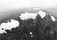 Ice cap at top of Puncak Jaya in Papua (1972).
 -
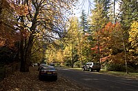 Autumn in the Blue Mountains, New South Wales.
 -
 A tropical rainforest in Papua New Guinea.
 -
 Simpson desert in Northern Territory.
 -
 Monsoonal squall in Darwin.
 -
 A billabong in the Kakadu National Park, Northern Territory. The monsoon climate of northern Australia is hot and humid in summer.
 -
 Snow in Jindabyne, New South Wales, a town in the Snowy Mountains.
 -
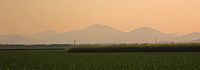 Grassland in Queensland with mountains in background.
 -
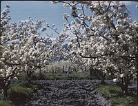 Spring in the apple orchards of Tasmania.


_(Tasmania)_-_(Frank_Hurley)_(9711313115).jpg)
Demography
Religion

Languages
"
Immigration
Since 1945, more than 7 million people have settled in Australia. From the late 1970s, there was a significant increase in immigration from Asian and other non-European countries, making Australia a
Economy
.jpg)
Australia is the only
Papua New Guinea is rich in natural resources, which account for two-thirds of their export earnings. Though PNG is filled with resources, the lack of country's development led foreign countries to take over few sites and continued foreign demand for PNG's resources and as a result, the United States constructed an oil company and began to export in 2004 and this was the largest project in PNG's history.[136][137] Papua New Guinea is classified as a developing economy by the International Monetary Fund.[138] Strong growth in Papua New Guinea's mining and resource sector led to the country becoming the sixth fastest-growing economy in the world in 2011.[139][140]
Politics
Australia is a
Papua New Guinea is a Commonwealth realm. As such, King Charles III is its sovereign and head of state. The constitutional convention, which prepared the draft constitution, and Australia, the outgoing metropolitan power, had thought that Papua New Guinea would not remain a monarchy. The founders, however, considered that imperial honours had a cachet.[147] The monarch is represented by the Governor-General of Papua New Guinea, currently Bob Dadae. Papua New Guinea (along with Solomon Islands) is unusual among Commonwealth realms in that governors-general are elected by the legislature, rather than chosen by the executive branch.

Culture
Since 1788, the primary influence behind Australian culture has been Anglo-Celtic Western culture, with some Indigenous influences.[148][149][150] The divergence and evolution that has occurred in the ensuing centuries has resulted in a distinctive Australian culture.[151][152][153] Since the mid-20th century, American popular culture has strongly influenced Australia, particularly through television and cinema.[154][150] Other cultural influences come from neighbouring Asian countries, and through large-scale immigration from non-English-speaking nations.[154][150][155][156] The Australian Museum in Sydney and the National Gallery of Victoria in Melbourne are the oldest and largest museums in the continent, as well as in Oceania.[157][158] Sydney's New Year's Eve celebrations are the largest in the continent.[159]
It is estimated that more than 7000 different cultural groups exist in Papua New Guinea, and most groups have their own language. Because of this diversity, in which they take pride, many different styles of cultural expression have emerged; each group has created its own expressive forms in art, performance art, weaponry, costumes and architecture. Papua New Guinea is one of the few cultures in Oceania to practice the tradition of bride price.[160] In particular, Papua New Guinea is world-famous for carved wooden sculpture: masks, canoes, story-boards.
Australia has a tradition of Aboriginal art which is thousands of years old, the best known forms being rock art and
-
 Kurulu Village War Chief at Baliem Valley in New Guinea
 -
![Didgeridoo player Ŋalkan Munuŋgurr performing with East Journey[165]](//upload.wikimedia.org/wikipedia/commons/thumb/e/e7/Didgeridoo_%28Imagicity_1070%29.jpg/200px-Didgeridoo_%28Imagicity_1070%29.jpg)

![Didgeridoo player Ŋalkan Munuŋgurr performing with East Journey[165]](/File:Didgeridoo_(Imagicity_1070).jpg)
Sport
Popular sports in Papua New Guinea include various codes of
See also
Notes
- ^ Most recent estimated population of Australia, Papua New Guinea (excluding the Islands Region), and Indonesia's Aru Islands Regency and Western New Guinea.
- ^ Excluding Christmas Island, the Cocos (Keeling) Islands, Heard Island and McDonald Islands, the Lord Howe Island Group (New South Wales), Macquarie Island (Tasmania), and Norfolk Island.
- ^ Excluding the Islands Region.
- ^ Excluding Cato Reef, Elizabeth Reef, Mellish Reef, Middleton Reef, and some small reefs on the Cato Trough.
References
- ISSN 0067-2238.
- ISSN 0305-4403.
- ISSN 0003-0082.
- ^ New, T.R. (2002). "Neuroptera of Wallacea: a transitional fauna between major geographical regions" (PDF). Acta Zoologica Academiae Scientiarum Hungaricae. 48 (2): 217–27.
- ^ Agency, Digital Transformation. "The Australian continent". info.australia.gov.au. Archived from the original on 1 May 2022. Retrieved 1 November 2021.
- ISBN 978-0-09-130460-7.
- ^ a b Seetharaman, G. (13 August 2017). "Seven decades after Independence, many small languages in India face extinction threat". The Economic Times.
- ^ "World Bank data on urbanisation". World Development Indicators. World Bank. 2005. Archived from the original on 3 February 2009. Retrieved 15 July 2005.
- ^ "BBC: First contact with isolated tribes?". Survival International. Retrieved 24 July 2015.
- ^ "Geographic Distribution of the Population". 24 May 2012. Retrieved 1 December 2012.
- ^ Data refer mostly to the year 2014. World Economic Outlook Database-April 2015, International Monetary Fund. Accessed on 25 April 2015.
- ^ "Australia: World Audit Democracy Profile". WorldAudit.org. Archived from the original on 13 December 2007. Retrieved 5 January 2008.
- ^ Statistics, c=AU; o=Commonwealth of Australia; ou=Australian Bureau of (19 May 2023). "Main Features – Cultural Diversity Article". www.abs.gov.au.
{{cite web}}: CS1 maint: multiple names: authors list (link) - ^ United Nations, Department of Economic and Social Affairs, Population Division, (2019). 'International Migration' in International migrant stock 2019. Accessed from International migrant stock 2015: maps on 24 May 2017.
- ^ "What Did Australia Look Like When the First People Arrived?". www.thoughtco.com.
- ISBN 978-0-7591-2390-8. Retrieved 6 August 2020.
- ISBN 9780199925070– via Google Books.
- ISBN 978-1-921313-04-2. Retrieved 6 August 2020 – via Google Books.
- ^ a b Lewis & Wigen, The Myth of Continents (1997), p. 32: "...the 1950s... was also the period when... Oceania as a "great division" was replaced by Australia as a continent along with a series of isolated and continentally attached islands. [Footnote 78: When Southeast Asia was conceptualised as a world region during World War II..., Indonesia and the Philippines were perforce added to Asia, which reduced the extent of Oceania, leading to a reconceptualisation of Australia as a continent in its own right. This manoeuvre is apparent in postwar atlases]"
- ^ Southwell, Thomas (1889). Transactions of the Norfolk and Norwich Naturalists' Society: Volume 4. Norfolk Naturalists' Trust and Norfolk & Norwich Naturalists' Society. Retrieved 16 November 2022.
- ^ The Journal of the Royal Aeronautical Society: Volume 36. Royal Aeronautical Society. 1932. Retrieved 16 November 2022.
- ^ Bartholomew, John (1873). Zell's Descriptive Hand Atlas of the World. T.E. Zell. p. 7. Retrieved 20 August 2022.
- ^ Goodrich, Samuel Griswold (1854). History of All Nations. Miller, Orton and Mulligan. Retrieved 20 December 2022.
- ^ a b c Wallace, Alfred Russel (1879). Australasia. The University of Michigan. p. 2. Archived from the original on 30 July 2022. Retrieved 12 March 2022.
Oceania is the word often used by continental geographers to describe the great world of islands we are now entering upon [...] This boundless watery domain, which extends northwards of Behring Straits and southward to the Antarctic barrier of ice, is studded with many island groups, which are, however, very irregularly distributed over its surface. The more northerly section, lying between Japan and California and between the Aleutian and Hawaiian Archipelagos is relived by nothing but a few solitary reefs and rocks at enormously distant intervals.
- ^ a b Cornell, Sophia S. (1857). Cornell's Primary Geography: Forming Part First of a Systematic Series of School Geographies. Harvard University. Archived from the original on 30 July 2022. Retrieved 31 March 2022.
- ISBN 9781576076941.
...defined here as the continent nation of Australia, New Zealand, and twenty-two other island countries and territories sprinkled over more than 40 million square kilometres of the South Pacific.
- ^ Lyons, Paul (2006). American Pacificism: Oceania in the U.S. Imagination. p. 30.
- ^ "Countries or areas / geographical regions". United Nations. Archived from the original on 30 August 2017. Retrieved 25 April 2019.
- ^ Status of the 1950 Census Program in the United States: A Preliminary Report. United States. Bureau of the Census. 1951. Retrieved 24 November 2022.
- S2CID 89935772.
- ISBN 978-0-520-20742-4.
Interestingly enough, the answer [from a scholar who sought to calculate the number of continents] conformed almost precisely to the conventional list: North America, South America, Europe, Asia, Oceania (Australia plus New Zealand), Africa, and Antarctica.
- ^ "Australia and Oceania - the World Factbook".
- ^ "Divisões dos continentes" (PDF). IBGE. Archived (PDF) from the original on 13 August 2021. Retrieved 12 January 2021.
- ^ Mears, Eliot Grinnell (1945). Pacific Ocean Handbook. J. L. Delkin. p. 45. Retrieved 27 July 2022.
- ^ Cust, Robert Needham (1887). Linguistic and Oriental Essays: 1847-1887. Trübner & Company. p. 518. Archived from the original on 30 July 2022. Retrieved 27 March 2022.
- ^ ISBN 0-7315-1540-4.
- ISBN 978-0-12-051250-8.
- ISBN 0-85905-036-X.
- ISBN 978-0-7301-0422-3.
- ISBN 978-0-14-015976-9.
- S2CID 150250671.
- ISBN 978-0-618-00583-3.
- ^ e.g. O'Connell, James F.; Allen, Jim (2007). "Pre-LGM Sahul (Pleistocene Australia-New Guinea) and the Archaeology of Early Modern Humans" (PDF). In Mellars, P.; Boyle, K.; Bar-Yosef, O.; Stringer, C. (eds.). Rethinking the Human Revolution. Cambridge: McDonald Institute for Archaeological Research. pp. 395–410. Archived from the original (PDF) on 3 November 2013. Retrieved 26 February 2008.
- ISBN 978-1-922103-43-7
- ^ Keith Lewis; Scott D. Nodder and Lionel Carter (11 January 2007). "Zealandia: the New Zealand continent". Te Ara: The Encyclopedia of New Zealand. Archived from the original on 25 July 2013. Retrieved 22 February 2007.
- ^ Norman, Kasih (2 April 2018). "Island-hopping study shows the most likely route the first people took to Australia". Phys.org. Retrieved 6 August 2020.
- ^ Johnson, David Peter (2004). The Geology of Australia. Port Melbourne, Victoria: Cambridge University Press. p. 12.
- ^ "Big Bank Shoals of the Timor Sea: An environmental resource atlas". Australian Institute of Marine Science. 2001. Archived from the original on 8 September 2006. Retrieved 28 August 2006.
- ^ Wirantaprawira, Dr Willy (2003). "Republik Indonesia". Dr Willy Wirantaprawira. Archived from the original on 18 October 2006. Retrieved 28 August 2006.
- ^ Kevin Mccue (26 February 2010). "Land of earthquakes and volcanoes?". Australian Geographic. Archived from the original on 6 March 2010. Retrieved 25 April 2010.
- ISBN 978-0732931209. Archivedfrom the original on 29 May 2016. Retrieved 13 June 2014.
- ISBN 9781444303810.
- ^ "Statistical Yearbook of Croatia, 2007" (PDF). dzs.hr. Retrieved 23 October 2017.
- ISBN 9780521331098. Retrieved 9 August 2018.
- PMID 31209234.
- S2CID 189927142.
- ^ Graham Lawton (25 January 2020). "The epic ocean journey that took Stone Age people to Australia". New Scientist.
- PMID 21940856.
- ^ Illumina (April 2012). "Sequencing Uncovers a 9,000 Mile Walkabout" (PDF). iCommunity Newsletter. Archived from the original (PDF) on 21 November 2018. Retrieved 10 February 2018.
- ISBN 9781760640446.
- ^ Jared Diamond. (1997). Guns, Germs, and Steel. Random House. London. pp 314–316
- S2CID 4365526.
- ISBN 0-7081-0452-5.
- ^ "The Indigenous Collection". The Ian Potter Centre: NGV Australia. National Gallery of Victoria. Archived from the original on 7 October 2010. Retrieved 6 December 2010.
- S2CID 129843692. Archived from the original(PDF) on 18 July 2003. Retrieved 24 May 2010.
- ^ Singh, Bilveer (2008). Papua: Geopolitics and the Quest for Nationhood. Transaction Publishers. p. 15.
- ^ "Majapahit Overseas Empire, Digital Atlas of Indonesian History". Archived from the original on 8 July 2011. Retrieved 8 February 2019.
- ^ "Early humans lived in PNG highlands 50,000 years ago". Reuters. 30 September 2010.
- ^ Albert-Marie-Ferdinand Anthiaume, "Un pilote et cartographe havrais au XVIe siècle: Guillaume Le Testu", Bulletin de Géographie Historique et Descriptive, Paris, Nos 1–2, 1911, pp. 135–202, n.b. p. 176.
- ^ "The Internet Classics Archive | Meteorology by Aristotle". classics.mit.edu.
- .
- ISBN 0-394-75303-8
- .
- ^ Carlos Pedro Vairo, TERRA AUSTRALIS Historical Charts of Patagonia, Tierra del Fuego and Antarctica. Ed. Zagier & Urruty Publicationa, 2010.
- ^ Spieghel der Australische Navigatie; cited by A. Lodewyckx, "The Name of Australia: Its Origin and Early Use", The Victorian Historical Magazine, Vol. XIII, No. 3, June 1929, pp. 100–191.
- ISBN 0-7270-0800-5
- ISBN 978-1-74126-688-7. Retrieved 12 June 2013.
- ^ "European discovery of New Zealand". Encyclopedia of New Zealand. 4 March 2009. Archived from the original on 10 November 2010. Retrieved 9 December 2010.
- ^ "Cook's Journal: Daily Entries, 22 April 1770". Retrieved 21 September 2011.
- ^ "Cook's Journal 29 April 1770".
- ^ "Once were warriors – smh.com.au". The Sydney Morning Herald. 11 November 2002. Retrieved 21 September 2011.
- ^ "Sydney's history". City of Sydney. 2013. Retrieved 5 July 2014.
- ^ "Early European settlement". Parliament of New South Wales. 2014. Archived from the original on 20 April 2016. Retrieved 17 August 2014.
- ^ John Waiko. Short History of Papua New Guinea (1993)
- ^ "Papua New Guinea". State.gov. 8 October 2010. Retrieved 14 July 2011.
- ^ "Bombing of Darwin: 70 years on – ABC News (Australian Broadcasting Corporation)". Abc.net.au. 17 February 2012. Retrieved 19 February 2014.
- ^ "Wartime Issue 23 – New Guinea Offensive | Australian War Memorial". Awm.gov.au. Retrieved 14 July 2011.
- ^ U.S. Dept. of Defence; International Crisis Group; and International Crisis Group Archived 8 August 2009 at the Wayback Machine. Archived 19 August 2014.
- ^ "Thirty Years On". The Economist. 25 August 2005.
- ^ cited in Michael Dugan and Josef Swarc (1984) p. 139
- ^ "DFAT.gov.au". DFAT.gov.au. 19 April 1984. Archived from the original on 16 February 2011. Retrieved 27 November 2014.
- ^ "Australia Burning: Fire Ecology, Policy and Management Issues" (PDF). CSIRO Publishing.
- ISBN 0-643-03548-6.
- ISBN 978-0816039739.
- ^ WWF: Bird wonders of New Guinea's western-most province, retrieved 11 May 2010
- ISBN 0-643-06749-3
- ^ Egerton, p. 122.
- ISBN 9780642568618.
- ^ Egerton, L. ed. 2005. Encyclopedia of Australian wildlife. Reader's Digest
- ^ "Australia's National Symbols". Department of Foreign Affairs and Trade. Retrieved 15 July 2015.
- ^ "Welcome" (PDF). Save the Tasmanian Devil. June 2008. p. 1. Archived from the original (PDF) on 17 February 2011. Retrieved 6 October 2010.
- ISBN 0-86438-018-6
- ^ Low, T. (2014), Where Song Began: Australia's Birds and How They Changed the World, Tyre: Penguin Australia
- ^ Centre, National Climate. "BOM – Climate of Australia". webarchive.nla.gov.au. Archived from the original on 17 March 2009.
- )
- ^ Christianity in its Global Context, 1970–2020 Society, Religion, and Mission, Center for the Study of Global Christianity
- ^ "Cultural diversity in Australia". 2071.0 – Reflecting a Nation: Stories from the 2011 Census, 2012–2013. Australian Bureau of Statistics. 21 June 2012. Archived from the original on 25 April 2016. Retrieved 27 June 2012.
- ^ "US Department of State International Religious Freedom Report 2003". Retrieved 23 March 2006.
- S2CID 204627919.
- ^ Statistics, c=AU; o=Commonwealth of Australia; ou=Australian Bureau of (21 June 2012). "Main Features – Cultural Diversity in Australia". www.abs.gov.au.
{{cite web}}: CS1 maint: multiple names: authors list (link) - ^ A.V. (24 July 2017). "Papua New Guinea's incredible linguistic diversity". The Economist. Retrieved 20 July 2017.
- ^ Papua New Guinea, Ethnologue
- ^ Statistics, c=AU; o=Commonwealth of Australia; ou=Australian Bureau of. "Main Features – Net Overseas Migration". www.abs.gov.au. Archived from the original on 10 October 2017. Retrieved 10 February 2018.
{{cite web}}: CS1 maint: multiple names: authors list (link) - ^ "Sydney's melting pot of language". The Sydney Morning Herald. 2014. Archived from the original on 23 September 2014. Retrieved 13 September 2014.
- ^ "Census 2016: Migrants make a cosmopolitan country". The Australian. 15 July 2017. Retrieved 16 July 2017.
- ^ "Population, dwellings, and ethnicity". .id. 2014. Retrieved 27 July 2014.
- ^ "Regional, rural and urban development - OECD" (PDF).
- ^ "Vicnet Directory Indian Community". Vicnet. Archived from the original on 28 September 2008. Retrieved 2 October 2008.
- ^ "Vicnet Directory Sri Lankan Community". Vicnet. Archived from the original on 16 October 2008. Retrieved 2 October 2008.
- ^ "Vietnamese Community Directory". yarranet.net.au. Archived from the original on 24 July 2008. Retrieved 2 October 2008.
- ^ "7BridgesWalk.com.au". Bridge History. Archived from the original on 29 August 2007. Retrieved 23 October 2006.
- Australian Government. 14 August 2008. Archived from the originalon 12 May 2012. Retrieved 29 May 2012.
- ^ "Melbourne, Australia: City of Literature Archived 4 September 2011 at the Wayback Machine", Creative Cities Network, UNESCO, retrieved: 10 August 2011
- ^ Field listing – GDP (official exchange rate), CIA World Factbook
- ^ "2012 Report (PDF)". Archived from the original on 4 September 2015. Retrieved 20 May 2014.
- ^ "Statement on Monetary Policy (November 2013)". 8 November 2013. Retrieved 20 May 2014.
- ^ Australian Bureau of Statistics (14 December 2017). "Tourism Satellite Account 2014–15:Key Figures".
- ^ "Visitor Arrivals Data". Tourism Australia. 10 January 2019. Archived from the original on 5 September 2015.
- ^ "2014 Quality of Living Worldwide City Rankings – Mercer Survey". mercer.com. 19 February 2014. Retrieved 24 October 2016.
- ^ "2014 Quality of Living Index". Mercer. 2014. Archived from the original on 21 August 2014. Retrieved 20 July 2014.
- ^ "The World According to GaWC 2010". Globalization and World Cities (GaWC) Study Group and Network. Loughborough University. Retrieved 22 April 2012.
- ^ "Global Power City Index 2010" (PDF). Tokyo, Japan: Institute for Urban Strategies at The Mori Memorial Foundation. October 2010. Retrieved 10 August 2011.
- ^ "Happy birthday Melbourne: 181 and still kicking!". www.sbs.com.au.
- ^ The Global Financial Centres Index 14 (September 2013) Archived 4 September 2015 at the Wayback Machine. Y/Zen Group. p 15. Retrieved 4 December 2013.
- ^ 2012 Global Cities Index and Emerging Cities Outlook Archived 30 December 2013 at the Wayback Machine. A.T. Kearney. p 2. Retrieved 29 December 2013.
- ^ "The World Factbook". www.cia.gov. Retrieved 14 March 2016.
- ^ "APECPNG2018.ORG". www.apecpng2018.org. Archived from the original on 9 July 2016. Retrieved 29 August 2016.
- ^ World Economic Outlook Database, October 2015, International Monetary Fund. Database updated on 6 October 2015. Accessed on 6 October 2015.
- ^ Asian Development Outlook 2015: Financing Asia’s Future Growth. Asian Development Bank (March 2015)
- ^ "Raising the profile of PNG in Australia". Australian Department of Foreign Affairs and Trade. 9 March 2012. Archived from the original on 13 May 2012. Retrieved 27 July 2012.
- ^ "How Australia's Parliament works". Australian Geographic. 11 August 2010. Retrieved 16 June 2014.
- ^ Davison, Hirst & Macintyre 1998, pp. 287–8
- ^ "Governor-General's Role". Governor-General of Australia. Archived from the original on 4 August 2008. Retrieved 23 April 2010.
- ^ "Glossary of Election Terms". Australian Broadcasting Corporation. Retrieved 23 April 2010.
- ^ "State of the Parties". Australian Broadcasting Corporation. Archived from the original on 18 April 2010. Retrieved 23 April 2010.
- ISBN 978-1-4860-0138-5.
- ISBN 978-1-57322-600-4.
- ^ Jupp, pp. 796–802.
- ^ Teo and White, pp. 118–20.
- ^ OCLC 1120581500.
- ^ Davison, Hirst & Macintyre 1998, pp. 98–9
- ^ Teo and White, pp. 125–27.
- ISBN 978-0-19-551503-9.
- ^ a b Teo and White, pp. 121–23.
- ^ Jupp, pp. 808–12, 74–77.
- OCLC 760277445.
- ^ Australian Museum, A Short History of the Australian Museum, http://australianmuseum.net.au/A-short-history-of-the-Australian-Museum
- ^ National Gallery of Victoria – Victorian Heritage Register
- ^ Kaur, Jaskiran (2013). "Where to party in Australia on New Year's Eve". International Business Times. Archived from the original on 8 July 2014. Retrieved 27 July 2014.
- ^ "Papua New Guinea – culture". Datec Pty Ltd. Archived from the original on 10 February 1999. Retrieved 16 December 2005.
- ^ "Australian Indigenous art". Australian Culture and Recreation Portal. Australia Government. 21 December 2007. Archived from the original on 16 April 2010. Retrieved 26 September 2010.
- ^ "Kakadu: Rock art". parksaustralia.gov.au. Retrieved 29 January 2017.
- ^ "Uluru-Kata Tjuta: Rock art". parksaustralia.gov.au. Retrieved 29 January 2017.
- ^ "Aboriginal Heritage walk: Ku-ring-gai Chase National Park". nationalparks.nsw.gov.au. Retrieved 29 January 2017.
- ^ Graves, Randin (2 June 2017). "Yolngu are People 2: They're not Clip Art". Yidaki History. Retrieved 30 August 2020.
- World Cup historyif Papua New Guinea – the only country to have Rugby League as its national Sport – were to qualify for the last 4.
- ISBN 0736810757
- ISBN 041568112X
- ISBN 0761414738
- ^ "FIFA world cup 2010 – qualifying rounds and places available by confederation". Fifa.com. 3 April 2009. Archived from the original on 28 February 2009. Retrieved 17 April 2009.
Bibliography
- Davison, Graeme; ISBN 978-0-19-553597-6.
- Lewis, Martin W.; ISBN 978-0-520-20743-1.
- Ebach, Malte C., ed. (2021). Handbook of Australasian Biogeography (1st ed.). CRC Press. ISBN 9780367658168.
External links
 Media related to Australia (continent) at Wikimedia Commons
Continents of Earth | ||||||||
|---|---|---|---|---|---|---|---|---|
| ||||||||
| ||||||||


