
Ponnani taluk
This article may require copy editing for grammar, style, cohesion, tone, or spelling. (July 2023) |
Ponnani Taluk | |
|---|---|
Taluk | |
KL-54 | |
| Website | talukofficeponnani-net |
Ponnani Taluk is a district in India.
It comes under
Overview
Ponnani Taluk is located right in the middle of the Kerala coast.
History
.svg)
Ponnani was the most populous Taluk of the erstwhile Malabar District during its dissolution.[3] At that time Ponnani Taluk had eight revenue blocks in it: Tanur, Tirur, Kuttippuram, Ponnani, Thrithala, Andathode, Chavakkad, and Nattika.[3][4] On 1 November 1957, the revenue blocks of Tanur, Tirur, and Kuttippuram were separated from Ponnani Taluk to form Tirur Taluk, and the Revenue blocks of Chavakkad and Nattika were separated to form Chavakkad Taluk.[4]
During the formation of Malappuram district on 16 June 1969, Ponnani taluk was separated from Palakkad district,[5]Thrithala Revenue block was transferred from Ponnani Taluk to Ottapalam Taluk, and three villages of Andathode Block namely, Punnayur, Punnayurkulam, and Vadakkekad, were transferred to the Chavakkad Taluk.[6]
Now, Ponnani is the smallest and least populous taluk of Malappuram district.[2] The current Ponnani Taluk contains only 11 villages.[2]
Villages

There are 11 villages in this taluk:[1]
- Ponnani Nagaram
- Veliyankode
- Maranchery
- Nannamukku
- Alamcode
- Vattamkulam
- Edappal
- Perumpadappa
- Thavanur
- Ezhuvathiruthy
- Kalady
Taluks of Malappuram
Ponnani Taluk under British Rule
Ponnani Taluk was created in 1860-1861 by merging Vettathunadu (Tanur) Taluk, Koottanad Taluk, and Chavakkad Taluk of erstwhile Malabar District.[7] Kuttippuram region of Cheranad (Tirurangadi) Taluk was also added to Ponnani Taluk.[7] The Amsoms included in Ponnani Taluk was classified into five divisions- Vettathunad, Cheranad, Koottanad, Chavakkad, the Island of Chetvai . There were 73 Amsoms in the Taluk.[7]
1. Vettathunad


Vettathunad, also known as the
- Pariyapuram
- Rayirimangalam
- Ozhur
- Ponmundam
- Tanalur
- Niramaruthur
- Trikkandiyur
- Iringavoor
- Klari
- Kalpakanchery
- Melmuri
- Ananthavoor
- Kanmanam
- Thalakkad
- Vettom
- Pachattiri
- Mangalam
- Chennara
- Triprangode
- Pallipuram
- Purathur[7]
2. Cheranad
The headquarters of Cheranad Taluk was the town of
3. Koottanad
The second home of the
- Thavanur
- Kalady
- Kodanad
- Melattur
- Chekkod
- Anakkara
- Keezhmuri
- Pothanur
- Eswaramangalam
- Pallaprom
- Ponnani
- Kanjiramukku
- Edappal
- Vattamkulam
- Kumaranellur
- Kothachira
- Nagalassery
- Thirumittacode
- Othalur
- Kappur
- Alamkod
- Pallikkara
- Eramangalam
- Vayilathur[7]
4. Chavakkad
Chavakkad had been under the suzerainty of the
5. The Island of Chetvai
The Island of Chetvai had been earlier under the suzerainty of the
Ponnani Canal
.jpg)
Ponnani Canal was constructed for the transportation of goods from Ponnani to Tirur railway station. Here is a description about the Ponnani Canal by Basel Mission employees at Codacal.[8]
...nowadays a steamship travels between Ponani and Tirur through the Canal, where the most convenient railway station for Ponnani is to be found. The ticket costs only 4 annas, although the distance is 10 km...
Historic maps
-
 Malabar District in 1854
 -
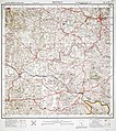 An area of Ponnani Taluk in 1912
 -
 Another area of Ponnani Taluk in 1912
 -
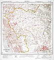
 An area of Ponnani Taluk in 1913
 -
 Malabar District in 1951

.jpg)
.jpg)
.jpg)
See also
- List of villages in Malappuram district
- List of Gram Panchayats in Malappuram district
- List of desoms in Malappuram district (1981)
- Revenue Divisions of Kerala
References
- ^ a b c "Villages, Taluks, and Revenues divisions that make up Malappuram district". Official website of Malappuram district.
- ^ a b c Directorate of Census Operations, Kerala. District Census Handbook, Malappuram (PDF). Thiruvananthapuram: Directorate of Census Operations, Kerala.
- ^ a b 1951 census handbook - Malabar district (PDF). Chennai: Government of Madras. 1953. p. 1.
- ^ a b Devassy, M. K. (1965). District Census Handbook (3) - Palakkad (1961) (PDF). Shoranur: Government of Kerala.
- ^ "History | Palakkad | India". Retrieved 30 August 2022.
- ^ K. Narayanan (1972). District Census Handbook - Malappuram (Part-C) - 1971 (PDF). Thiruvananthapuram: Directorate of Census Operations, Kerala. p. 3.
- ^ ISBN 9788120604476.
- ^ Website of Ines Zupanov