
Ernakulam district
This article may require cleanup to meet Wikipedia's quality standards. The specific problem is: references and uncited sections. (September 2023) |
Ernakulam district | |
|---|---|
        Clockwise from top: Kothamangalam | |
| HDI (2005) | very high |
| Website | ernakulam |
Ernakulam (IPA:
The district includes the largest metropolitan region of the state:
The most commonly spoken language in Ernakulam is Malayalam. English is widely used, mostly in business circles. Ernakulam became India's first district to have 100 percent banking or full "meaningful financial inclusion" in 2012.[6][7]
Ernakulam has a high Human Development Index of 0.801 (UNHDP report 2005), which is one of the highest in India.[8]
Etymology
This section is empty. You can help by adding to it. (August 2023) |
History


Ernakulam has played a part in the political history of
In the year 1998, Kuttampuzha village was added to the district from Idukki district following which the district got a political boundary with neighbouring state of Tamil Nadu. There is no interstate road that connects the district with the neighbouring state through this border.
Geography
This section needs additional citations for verification. (September 2020) |
The Ernakulam district covers an area of 3,068 km2 (1,185 sq mi) on the Western Coastal Plains of India. It is surrounded by the
The district houses two Urban Agglomerations,
Topography
The district is divided into three parts: lowland, midland, and the highland that consist of seaboard, plains, and hills and forests respectively. 20 percent of the total area are lowlands. The forests in the eastern part of the district are mostly remote, forming a part of the
Forest and wildlife

The flora of this district is tropical. The heavy rainfall combined with moderate temperatures and fertile soil support abundant vegetation. Many of the common plants are found in the coastal area, which forms the lowland region. The midland region is occupied by coconut palms, paddy, tapioca, pepper, pineapple and pulses. The lower slopes of the highland region have teak and rubber.
Mangalavanam Bird Sanctuary

Thattekad Bird Sanctuary
Climate
| Climate data for Kochi | |||||||||||||
|---|---|---|---|---|---|---|---|---|---|---|---|---|---|
| Month | Jan | Feb | Mar | Apr | May | Jun | Jul | Aug | Sep | Oct | Nov | Dec | Year |
| Record high °C (°F) | 35 (95) |
37 (99) |
37 (99) |
34 (93) |
35 (95) |
33 (91) |
35 (95) |
35 (95) |
38 (100) |
35 (95) |
34 (93) |
33 (91) |
38 (100) |
| Mean daily maximum °C (°F) | 30 (86) |
31 (88) |
31 (88) |
31 (88) |
31 (88) |
28 (82) |
28 (82) |
28 (82) |
28 (82) |
29 (84) |
30 (86) |
30 (86) |
30 (86) |
| Mean daily minimum °C (°F) | 23 (73) |
25 (77) |
26 (79) |
26 (79) |
26 (79) |
25 (77) |
24 (75) |
24 (75) |
25 (77) |
25 (77) |
25 (77) |
23 (73) |
25 (77) |
| Record low °C (°F) | 17 (63) |
18 (64) |
20 (68) |
21 (70) |
22 (72) |
21 (70) |
21 (70) |
20 (68) |
22 (72) |
20 (68) |
20 (68) |
19 (66) |
17 (63) |
| Average precipitation mm (inches) | 21.9 (0.86) |
22.9 (0.90) |
35.3 (1.39) |
124.0 (4.88) |
395.7 (15.58) |
720.7 (28.37) |
697.2 (27.45) |
367.8 (14.48) |
289.4 (11.39) |
302.3 (11.90) |
175.1 (6.89) |
48.3 (1.90) |
3,228.3 (127.10) |
| Source 1: [14] | |||||||||||||
| Source 2: [15] | |||||||||||||
Economy


Ernakulam district is the richest district in Kerala and is the biggest commercial centre in the state of Kerala. It contributes the most to the state exchequer in terms of GSVA and tax revenues. It has the highest literacy rate as well as the highest per capita income in the state, along with having the greatest number of commercialised banks, startups and large-scale industries & MSMEs in the state. Its M.G. Road is home to some of
The sea along the entire coast of the district and its backwaters are the habitat of various kinds of fish that supply both marine and inland fisheries.
Agriculture
The eastern part of Ernakulam is primarily agrarian in nature.
Education

Ernakulam is the first district in India to have 100 percent literacy by 1990. In fact Kochi has the highest literacy rate for any city in the country with over 20 lakhs population. Pothanikkad is the first village in India that achieved 100 percent literacy according to state literacy programme is in this district.[citation needed]
There are three prominent universities in Ernakulam: Sree Sankaracharya University of Sanskrit in Kalady, Cochin University of Science and Technology in Kalamassery, and Kerala University of Fisheries and Ocean Studies in Kochi. The district has the most educational institutions in the state; as of 2019, there are 476 fully high-tech schools in Ernakulam.[16]
In 2017, Ernakulam district administration launched the Roshni project, which aims to provide Malayalam education to migrant children. It supported 1,265 migrant workers’ children from lower primary to high school.[17]
Divisions
There are two revenue divisions: Fort Kochi and Muvattupuzha. The municipal corporation is in Kochi.
Taluks
The district has the most taluks in the state. The district is divided by two revenue divisions with seven taluks.
- Paravur
- Aluva
- Kunnathunad
- Muvattupuzha
- Kochi
- Kanayannur
- Kothamangalam
Municipalities
Interestingly, Ernakulam district has the most municipalities in the state.
- North Paravur
- Piravom
- Muvattupuzha
- Koothattukulam
- Perumbavoor
- Aluva
- Angamaly
- Thripunithura
- Kalamassery
- Kothamangalam
- Eloor
- Maradu
- Thrikkakara
A criticism that has been centered around this fact is that despite municipalities like Aluva, Kalamassery, Thrikkakara, Maradu, Tripunithura and Eloor becoming assimilated into Kochi city, they still exist as individual municipalities instead of being under
Parliamentary Constituencies
- Ernakulam Parliamentary Constituency
- Chalakudy Parliamentary Constituency(partially)
- Idukki Parliamentary Constituency(parts of Muvattupuzha taluk and Kothamangalam taluk)
- Kottayam Parliamentary Constituency(parts of Muvattupuzha taluk and Kanayannur taluk)
Assembly Constituencies
- Piravom
- Angamaly
- Aluva
- Kalamassery
- North Paravur
- Vypin
- Kochi
- Ernakulam
- Thrikkakara
- Thripunithura
- Perumbavoor
- Kunnathunad
- Moovattupuzha
- Kothamangalam
Demographics
| Year | Pop. | ±% p.a. |
|---|---|---|
| 1901 | 646,235 | — |
| 1911 | 735,267 | +1.30% |
| 1921 | 789,311 | +0.71% |
| 1931 | 982,731 | +2.22% |
| 1941 | 1,172,292 | +1.78% |
| 1951 | 1,393,679 | +1.74% |
| 1961 | 1,702,740 | +2.02% |
| 1971 | 2,170,820 | +2.46% |
| 1981 | 2,549,255 | +1.62% |
| 1991 | 2,840,279 | +1.09% |
| 2001 | 3,105,798 | +0.90% |
| 2011 | 3,282,388 | +0.55% |
| 2018 | 3,427,659 | +0.62% |
| source:[19] | ||
According to the
According to the
This district is listed as the "most advanced" district in Kerala. It had a resident population of 3,105,798 as of 2001, excluding the commuters from neighbouring districts.[21]
According to the 2011 Census of India, Ernakulam District also houses the largest city (UA) in the state (17th largest in the country) -
The district also houses another smaller urban agglomeration -
Religion
| Talukas | Hindus | Christians | Muslims | Others |
|---|---|---|---|---|
| Kunnathunad | 45.32 | 35.39 | 19.16 | 0.13 |
| Aluva | 37.78 | 44.64 | 17.29 | 0.29 |
| Paravur | 56.69 | 28.93 | 14.13 | 0.25 |
| Kochi | 41.74 | 41.15 | 16.67 | 0.44 |
| Kanayannur | 53.16 | 34.49 | 11.91 | 0.44 |
| Muvattupuzha | 40.53 | 45.14 | 14.12 | 0.21 |
| Kothamangalam | 36.16 | 41.82 | 21.77 | 0.25 |
Ernakulam also has a significant


Culture
Festivals and traditions
The Aluva Sivarathri festival at the Aluva Mahadeva Temple (situated on the banks of river Periyar) in Aluva attracts people from around the country.
St. Mary's Orthodox Syrian Cathedral, Piravom is believed to be founded in 405 A.D. and was the headquarters of Archdeacon and St Thomas until the 18th century.
Kallil Kshethram is a famous Jain temple near Perumbavoor.
The eight-day lent (Ettunombu) festival at
Important pilgrimage sites in Ernakulam are Koonan Kurish St George Orthodox Pilgrim church,
Places of interest
- Marine Drive, Kochi
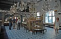
- Kadavumbhagam Mattancherry Synagogue
- Kadavumbhagam Ernakulam Synagogue
- Paradesi Synagogue: Constructed in 1567, only active synagogue in the Kochi.
- Chinese Fishing Nets(Cheena Vala)
- Hill Palace, Tripunithura
- Bolgatty Island
- Willingdon Island
- Dutch Palace: Made in 1568 by the Portuguese. Later re-structured by the Dutch.
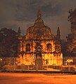
- St. Francis Church, Kochi: Originally built in 1503, the oldest European church in India
- Kodanad: Elephant training centre is located here.
- Pareekshit Thampuran Museum
- Kerala Historical Museum: Located at Edappally
- Chendamangalam, a village
- Palium Palace
- Vypeenakotta Seminary
- Bhoothathankettu, a scenic dam site
- St. Thomas Syro-Malabar Catholic Church, Malayattoor: The only international shrine in Asia. Believed to have been visited by St. Thomas, the apostle.
- Wonder La, Kakkanad: Amusement park
- Cherai Beach.
- Kuzhippilly Beach[28]
- Fort Kochi Beach
- Paniyeli Poru
- Ezhattumugham
Transport
Road connectivity
The three major national highways passing through Ernakulam are the Cochin-Mumbai Highway (NH 66), Salem-Kanyakumari (NH 47 part of NSEW corridor), and Cochin-Dhanushkodi highway (NH 49).
Railway station
Ernakulam has 17 railway stations. The
Airport
Ernakulam district has two airports: Naval airport in W.island (Old Cochin airport) and Cochin International Airport (CIAL). CIAL is the fourth largest airport in the country after Mumbai, Delhi, and Chennai, and serves International passengers.
Water transport
Ernakulam lies in the flat delta region of the Periyar and Moovattupuzha rivers. Water transport is prominent in the district via rivers and lagoons.
Notable people
- Adi Sankaracharya(Saint Advaita)
- Abraham Barak Salem (Jewish Gandhi))
- Ajay Kudua (cricketer)
- Swami Chinmayananda(Indian spiritual leader and geetacharya )
- Geevarghese Mar Gregorios of Parumala(Syrian Orthodox Saint)
- Paulose Mar Athanasius(Syrian Orthodox Saint)
- Shadkala Govinda Marar (Carnatic musician)
- Sahodaran Ayyappan (social reformer and former minister of Kochi State)
- K J Yesudas(singer)
- Changampuzha(poet)
- Malayattoor ramakrishnan (novelist)
- NS Madhavan(writer)
- N. A. Naseer (photographer, activist and author)
- Sebastian Paul (politician)
- Simon Britto Rodrigues (politician)
- Feroze V Rasheed (cricketer)
- K Jayaraman(cricketer)
- G. Sankara Kurup (poet)
- P K Vasudevan Nair(former chief minister)
- Balachandran Chullikad(poet and actor)
- Sreesanth(cricketer)
- K. V. Thomas (politician)
- Asin Thottumkal(actress)
- Jayasurya (actor)
- Cochin Haneefa (actor)
- Sreejesh Ravindran(hockey player)
- Sankaradi (actor)
- Salim Kumar (actor)
- T. K. Narayana Pillai(former chief minister of Kerala)
- Jayaram (actor)
- Lalu Alex (actor)
- Hibi Eden (politician)
- K. M. George (politician)
- Francis George (politician)
- Johnny Nellore (politician)
- T. M. Jacob (politician)
- Anoop Jacob (politician)
- Jose Thettayil (politician)
- Revathi (actress)
- Dulquer Salmaan (actor)
- Nivin Pauly (actor)
- Lal (actor)
- Rajeev Ravi (director and cinematographer)
- Subi Suresh (actress and comedian)
Gallery
-
 Paradesi Cochin Jewish Synagogue
 -
 St. Francis Church
 -
 Chinese Net Bridge at Marine Drive walkway
 -
 The old Dutch cemetery in Kochi
 -
 School in Old Kochi
 -
 Fishing nets in Fort Kochi
 -

-
 High Court of Kerala at Ernakulam
 -
 Heritage Building of Ernakulam District Court


See also
References
- ^ a b Annual Vital Statistics Report - 2018 (PDF). Thiruvananthapuram: Department of Economics and Statistics, Government of Kerala. 2020. p. 55. Archived from the original (PDF) on 2 November 2021. Retrieved 30 October 2020.
- ^ "Demography -Ernakulam" (PDF). Directorate of Census Operations, Kerala. Retrieved 4 July 2020.
- ^ "Kerala | UNDP in India". UNDP.
- ISBN 9788193456781. Retrieved 2 October 2020.
- ^ a b c d e f "District Census Hand Book: Ernakulam" (PDF). Census of India. Registrar General and Census Commissioner of India.
- ^ "Ernakulam to be declared first district with 100% banking". The Hindu Businessline. 15 November 2012. Archived from the original on 1 February 2013. Retrieved 27 February 2013.
- ISBN 9788171415533.
- ^ "Kerala". UNDP in India. Retrieved 10 October 2019.
- ^ The Portuguese, Indian Ocean and European Bridgeheads 1500–1800. Festschrift in Honour of Prof. K. S. Mathew (2001). Edited by: Pius Malekandathil and T. Jamal Mohammed. Fundacoa Oriente. Institute for Research in Social Sciences and Humanities of MESHAR (Kerala)
- ^ M K Sunil Kumar (26 September 2017). "50 years on, Kochi still has a long way to go". The Times of India. Retrieved 1 June 2021.
- ^ "Mangalavanam Bird Sanctuary". Kerala Tourism Development Corporation. Retrieved 21 January 2018.
- ^ "Green Lung of Kochi". cochin.org. Retrieved 3 April 2016.
- ^ "Mangalavanam Bird Sanctuary". Kochi Servnet. Archived from the original on 23 September 2016. Retrieved 12 November 2015.
- ^ "Kochi, India". Whetherbase. August 2011. Retrieved 1 July 2010.
- ^ "Kochi, India". MSN India. Archived from the original on 14 July 2011. Retrieved 3 August 2010.
- ^ "Now, Ernakulam has 476 fully high-tech schools". The Hindu. 7 December 2019 – via www.thehindu.com.
- ^ Shreehari Paliath, IndiaSpend com. "In Kerala's Ernakulam district, a programme is helping migrant children stay in school". Scroll.in.
- ^ "Chamber calls for expansion of Kochi Corp - The New Indian Express".
- ^ "Census of India Website : Office of the Registrar General & Census Commissioner, India". www.censusindia.gov.in.
- ^ a b "Table C-16 Population by Mother Tongue: Kerala". www.censusindia.gov.in. Registrar General and Census Commissioner of India.
- ^ "censusindia.gov.in" (PDF).
- ^ "आवासन और शहरी कार्य मंत्रालय, भारत सरकार". Mohua.gov.in. Retrieved 7 May 2022.
- ^ a b "Table C-01: Population by religious community: Kerala". Census of India. Registrar General and Census Commissioner of India. 2011.
- ^ Official Ernakulam District Profile Archived 21 July 2011 at the Wayback Machine
- ^ "Exploring Kochi through a Goan lens". The New Indian Express.
- ^ "Jain festival celebrated in city | Kochi News - Times of India". The Times of India.
- ^ "Sikh families: The Sikhs here love Kochi | Kochi News - Times of India". The Times of India.
- ^ "Kuzhupilly Beach". www.kuzhupillybeach.com.
Further reading
- U. Sivaraman Nair (1952), 1951 Census Handbook- Trichur District (PDF), Trivandrum: Travancore-Cochin Government Press
- M. K. Devassy (1965), 1961 Census Handbook- Ernakulam District (PDF), Directorate of Census Operations, Kerala and The Union Territory of Laccadive, Minicoy, and Amindivi Islands
- Government of India (2014–15), District Census Handbook - Ernakulam (Part-A) 2011 (PDF), Directorate of Census Operations, Kerala
- Government of India (2014–15), District Census Handbook - Ernakulam (Part-B) 2011 (PDF), Directorate of Census Operations, Kerala
External links
Places adjacent to Ernakulam district | ||||||||||||||||
|---|---|---|---|---|---|---|---|---|---|---|---|---|---|---|---|---|
| ||||||||||||||||

| International | |
|---|---|
| National | |