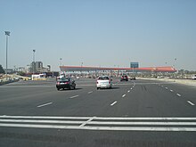
Delhi–Gurgaon Expressway
Source: Wikipedia, the free encyclopedia.
Road in India
| Delhi–Gurugram Expressway | |
|---|---|
Delhi–Gurugram Expressway highlighted in red | |
| Route information | |
| Length | 27.7 km (17.2 mi) |
| Existed | 23 January 2008–present |
| Major junctions | |
| West end | Manesar (Gurugram) |
| East end | Delhi |
| Location | |
| Country | Gurugram |
| Highway system | |


The Delhi–Gurugram Expressway on
National Highway Development Project. The ₹10 billion (US$119.8 million), 27.7 km (17.2 mi) brownfield expressway was opened in phases with the final section opening on 23 January 2008. This expressway is the busiest inter-city route in India and handles more than 180,000 PCUs daily.[3] It starts at Dhaula Kuan in Delhi and terminates on the outskirts of Gurugram
. Gurugram City is located at both sides of this Expressway.
See also
- Expressways in India
- Highways passing from Delhi
- List of highways in Haryana
- National highways of India
- National Highways Development Project
References
- ^ "Excess cars made tolling a taxing truth at first: Expressway builder". Express India. Archived from the original on 20 November 2008. Retrieved 16 September 2010.
- ^ "DSC Limited : Creating Infra Wealth". dsclimited. Retrieved 10 July 2015.
- ^ "Easy entry for Visa card holders". The Times of India. Times News Network. 8 January 2009. Archived from the original on 17 September 2011. Retrieved 16 September 2010.
External links
Wikimedia Commons has media related to Delhi–Gurgaon Expressway.


