
Markanda River (Haryana)
| Markanda River | |
|---|---|
Sirmaur District, Himachal Pradesh | |
| Mouth | Ghaggar River |
• location | Himachal Pradesh, India |
• coordinates | 30°05′26″N 76°23′39″E / 30.0905°N 76.3943°E |
| Length | 90 km (56 mi) |
| Basin features | |
| Tributaries | |
| • left | Begna river, Ran, nakati |
| Waterbodies | Jalbehra barrage in Kurukshetra |
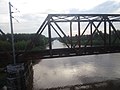
| Bridges | Markanda Bridge, Haryana |
The Markanda ( The Markanda river's ancient name was Aruna.
Origin and route
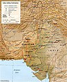
The Markanda river is an eponymous seasonal river in Haryana state, which is a main tributary of the Ghaggar River.[3]
The Markanda river originates in the
Shivalik hills on the border of Haryana and Himachal Pradesh State, and flows along the haryana and Punjab, India border before meeting with Ghaggar river at the confluence.[4]
The basin is classified in two parts, Khadir and Bangar, the higher area that is not flooded in rainy season is called Bangar and the lower flood-prone area is called Khadar.[4]
Several archaeologists identify the old
Gallery
-
 Indus–Sarasvati civilisationmajor sites
 -
-
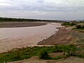
 Markanda River at Markanda, Haryana


See also
- Dangri, a tributary of Sarsuti
- Tangri river, a tributary of Sarsuti, merge if Dangri and Tangri are same
- Sarsuti, a tributary of Ghaggar-Hakra River
- Kaushalya river, a tributary of Ghaggar-Hakra River
- Chautang, a tributary of Ghaggar-Hakra River
- Indus
- Ganges
- Indus
- Western Yamuna Canal, branches off Yamuna
References
- ^ AmbalaOnline - Rrvers of Ambala
- ^ Chopra, Sanjeev (25 September 2010). "Overflowing Ghaggar, Tangri inundate some villages along Punjab-Haryana border". The Indian Express. Retrieved 9 April 2017.
- ISBN 978-81-8069-028-0.
- ^ a b HaryanaOnline - Geography of Haryana Archived 1 February 2016 at the Wayback Machine
- S2CID 161129625
- ISBN 1560987227
- ISBN 978-0-521-28550-6
- ISBN 978-3-11-014447-5
External links
Wikimedia Commons has media related to Ghaggar-Hakra river.
Wikimedia Commons has media related to Sarasvati River.
Wikimedia Commons has media related to Indus Valley Civilization.
- Sarasvati-Sindhu civilization and Sarasvati River
- The Saraswati: Where lies the mystery by Saswati Paik
| Rivers |
|
|---|---|
| Lakes |
|
| Dams, barrages | |